.31 Acres Near Lakes Arkansas
1502 Council Dr : Horseshoe Bend, AR 72512
Izard County, Arkansas
Land Description
Owner Financing:
- $112 down (plus the $249 non refundable doc fee)
- $112 down $112/Mo for 36 months (plus prorated taxes and note maintenance fee)
You have driven roads like this before. Dirt, quiet, trees closing in on both sides. You know what that means before you even step out of the truck.
This is that kind of land.
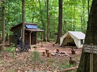
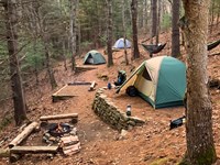
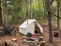
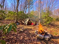
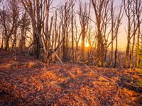
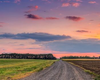
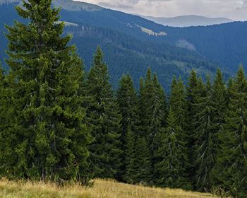
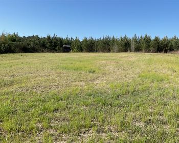
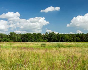
This 0.31-Acre parcel in Izard County, Arkansas sits inside a full hardwood canopy with cedar mixed throughout. Flat ground, complete tree cover, dirt road access. Diamond Lake is 0.9 miles from the property line. Crown Lake is 1.6 miles out. From above, you can see both.
That is the setup. Here is what it actually means.
What You Are Walking Into
The canopy is mixed - mature hardwoods and cedar clusters that hold green after the leaves drop. You already know what that does in November. Cover that stays when everything else goes bare is the kind of cover that holds deer, holds turkey, holds the animals that know where to be when pressure picks up everywhere else.
Think about what happens to public ground once bow season opens. The pressure starts slow and builds. By the time rifle season rolls in, every piece of accessible timber within range of a parking lot has been pushed, walked, and educated. Deer that survived two or three seasons did not do it by accident. They found the places that do not get hit. Mixed canopy close to water, flat enough to move through quietly, far enough off the main road that most people do not bother. That is exactly what this ground is.
The cedar holds when the hardwoods drop. That matters more than people give it credit for. A mature deer in late season is not looking for open timber. He is looking for the last place that still feels safe. Cedar mixed into hardwoods gives him that. It gives you that too - natural cover for a blind, natural screening for your approach, natural structure that does not require you to build anything or clear anything. The land does the work.
The ground is flat. You can move quietly. You can set a blind where the terrain tells you to, run a trail camera on your own timeline, and learn this land the way you learn any good piece of ground - slowly, on your own terms. Flat ground also means you can access every corner of this parcel without burning out your legs or your patience. You cover it cleanly. You learn it fast. And once you know it, you know it for every season that follows.
Spring turkey in mature hardwoods sounds like something worth getting up early for. It is. The gobbling carries differently through mixed timber than it does across open ground. You set up in the dark, listen to the woods wake up, and work the morning the way it deserves to be worked. Summer means scouting - velvet bucks moving early, patterns forming before the pressure of fall changes everything. Fall is what this ground was built for. And winter, when everything else has gone quiet, this canopy still holds. The cedar still screens. The deer still move. The land gives you a reason to be out here in every month the calendar offers.
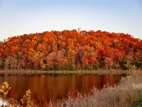
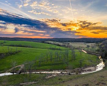
The lakes are not a backdrop. Diamond Lake sits less than a mile out. Crown Lake is just over a mile and a half. Both are visible from altitude above this property. That proximity means the wildlife corridor here stays active. Deer move toward water. Ducks follow it. Bass do not care about the calendar. You have two lakes within reach and hardwood cover between you and both of them. That combination is rare at this price point in Arkansas.
Pull up the drone footage before you make a decision on any piece of land. This one holds up.
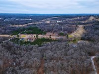
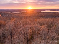
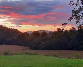
The first image looks north. Dirt road, unbroken canopy, Crown Lake sitting open at the edge of the frame. No clearing, no neighbors pressing in. Just timber running to the water. The second looks toward Diamond Lake - shoreline curving through the tree line, cabins quiet on the far bank, cedar clusters showing deep green in the foreground while everything else has gone bare. A truck near the property gives you the scale. You have seen enough aerial shots to know when one is telling the truth. This one is.
The Water
Crown Lake and Diamond Lake are not recreational destinations built for crowds. They are working lakes in a quiet Arkansas county - the kind of water that draws the right people for the right reasons. Anglers who want an early morning without a boat ramp circus. People who know what lake-adjacent timber does to deer movement. Waterfowl that follow water regardless of what the calendar says.
Crown Lake sits open and wide to the north. On a calm morning the surface holds still long enough to make you feel like you are the only person who found it. Bass move along the timber edges in the early hours before the sun gets high. Crappie stack in the deeper water when the season turns. The lake does not ask anything of you. It just produces for the person willing to show up before everyone else does.
Diamond Lake curves through the tree line to the northeast. Its character is quieter - more intimate shoreline, less open water, the kind of place that feels personal once you know it. Kayak it early in the morning before the light fully breaks and you understand why people who find water like this tend to keep coming back. It is not dramatic. It is consistent. And consistent is what you want from water you plan to fish for the next twenty years.
Owning ground inside that corridor means you are part of the system, not watching it from the road. The wildlife moves between the timber and the water the same way it always has - on corridors that have been established for longer than any of us have been hunting them. Deer that bed in mixed timber close to water are using the same logic they always use. They want cover. They want a water source within range. They want flat ground they can move through quietly at last light. This parcel sits at the center of all three.
The waterfowl movement through this area follows the lakes. Ducks that work the timber edges at first light, moving between Crown and Diamond on their own schedule, pass over ground like this on every pass. You do not need to be on the water to intercept that movement. You need to be close enough to it that the birds are still low and committed when they cross your position. Less than a mile from Diamond Lake puts you inside that window.
Wooded, flat, private land within two miles of two lakes in Izard County holds its character. The trees grow. The lakes stay. That is what makes it worth holding.
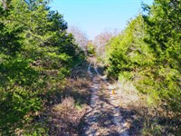
The road in is dirt. Light traffic, no neighborhood infrastructure, a second road angling in from the northwest if you want options. You have driven worse to reach better ground. This one is easy.
Horseshoe Bend is five miles out - fuel, hardware, a meal before you head in for the evening. Little Rock is two and a half hours south. Far enough that the drive means something. Close enough that a long weekend from most of the state makes sense, especially in season.
This property has no HOA. Local county guidelines govern use of the land, and our team will walk you through exactly what Izard County allows for your specific plans - structures, access, or anything else you are considering - before you commit to anything. Utilities are available nearby when you are ready for them. APN 0. Taxes run approximately $180 a year.
The land is priced at $3,495 cash. Owner financing is available - $112 down, $112 per month for 36 months, plus a one-time non-refundable $249 non refundable doc fee. Nothing hidden, nothing complicated.
Why This One
Small parcels of wooded land in Arkansas near natural water do not sit long when the right person finds them. Demand for hunting land in Arkansas has grown every year. The supply of quality recreational land near lakes at this price has not kept up. That gap is real and it is widening. The person who has been watching land in this part of Arkansas for any length of time already knows what a parcel like this is worth when it surfaces at this number.
But the value here is not just about the market. It is about what this specific piece of ground gives you over time.
You are not buying a property to flip. You are buying a base. Somewhere that belongs to you in a county you already want to spend time in, or a county worth building a relationship with from the ground up. A fixed point that stays the same while everything else around your life keeps moving. Land like this does not ask much of you. It does not need maintenance schedules or improvement plans or weekend work parties. It needs a person who shows up, pays attention, and puts in the time to learn what the ground is telling them.
That is the kind of ownership that pays off in ways that do not show up on a spreadsheet. The morning you arrow a mature buck on a corridor you identified two seasons ago. The afternoon you pull bass off a structure you found by accident the first time you kayaked Diamond Lake. The November evening you sit in mixed cedar and hardwood and watch the light change and think about how long you want to hold this ground and what it might mean to hand it down one day.
Izard County rewards the person who stays. The people who own land here tend to hold it. The ground that changes hands in this county changes hands because life changes - not because the land disappointed anyone. That tells you something worth knowing before you decide.
This is not complicated land to understand. Flat ground, mixed canopy, two lakes inside two miles, dirt road in. You know what to do with that. The only question is whether you want it.
If you have been looking for a piece of Arkansas to call your base - somewhere with good timber, water close, and ground that rewards the person who knows how to use it - this one is worth picking up the phone over.
Ownership like this deserves a real conversation before someone else has it.
Call us today. We will walk through the access, the terms, and everything the land allows so you feel completely clear before making a move. You will speak with someone who takes this seriously and will give you the full picture - no pressure, just the information you need to decide.
State: Ar
County: Izard
Zip: 72512
Size: 0.31 acres
Apn: 0
Legal Description: Lot 191 Executive S-T-R: 14-18-07
Lat/Long Coordinates:
Nw: 36.209657, -91.699459
Ne: 36.209808, -91.699237
Sw: 36.209362, -91.699132
Se: 36.209513, -91.698909
Elevation: 808 ft feet
Annual Taxes: Approx. $96 per year
Zoning: Residential
Flood Zone: No
HOA/POA: No
Improvements: No improvements done.
Access: Dirt Road
Water: Will need to install a Well
Sewer: Will need to install a Septic System
Utilities: Electric
Owner Financing:
- $112 down (plus the $249 non refundable doc fee)
$112 down $112/Mo for 36 months (plus prorated taxes and note maintenance fee)
We do not offer owner financing for residential use or full-time living on the property during the financing term.
Land Maps & Attachments
Directions to Land
From Little Rock, Arkansas, USA to 1502 Council Dr, Horseshoe Bend, AR 72512, USA
-Get on I-630 E 2 min (0.3 mi)
-Head north toward W 8th St 131 ft
-Turn right at the 1st cross street onto W 8th St 0.2 mi
-Use any lane to take the ramp onto I-630 E 0.1 mi
-Follow I-57/US-167 N/US-67 N to AR-56 W/E Arkansas 56/Franklin Rd in Ash Flat 2 hr 12 min (130 mi)
-Merge onto I-630 E 1.4 mi
-Use the left 2 lanes to take exit 139A-139B for I-30 E toward N Little Rock 0.4 mi
-Keep left and merge onto I-30 E 2.8 mi
-Use the right 2 lanes to take exit 143B to merge onto I-40 E/US-167 N/US-67 N toward Jacksonville/Memphis
1.6 mi
-Use the left 2 lanes to take exit 155 for US-67/US-167 N toward Jacksonville/L.R.A.F.B 0.6 mi
-Continue onto I-57/US-167 N/US-67 N 54.4 mi
-Take exit 55 for US-64 E/US-167 N toward Bald Knob/Batesville 0.3 mi
-Slight left onto the US-167 N ramp 108 ft
-Turn left onto US-167 N/US-64 W
-Continue to follow US-167 N
-Pass by Taco Bell (on the left in 33.5 mi) 69.2 mi
-Continue on AR-56 W/E Arkansas 56. Drive to Council Dr in Horseshoe Bend 10 min (7.4 mi)
-Turn left onto AR-56 W/E Arkansas 56/Franklin Rd
-Continue to follow AR-56 W/E Arkansas 56 5.6 mi
-Turn right onto S Pine Ridge Dr 1.7 mi
-Turn right onto Council Dr
-Destination will be on the right 0.2 mi
More Land Details
More Land from Chris Palsgrove
 3.2 AC : $45.8K
- 1.4 AC : $23.7K
- 0.4 AC : $50K
- 0.3 AC : $3.4K
- 1.4 AC : $20K
- 1.1 AC : $18K
- 0.4 AC : $6K
- 1.1 AC : $14K
- 0.4 AC : $4.7K
- 0.3 AC : $3.2K
- 0.4 AC : $50K
- 4.9 AC : $8K