5.27 Acres CO Mountains 279 Down
2049 Pfotenhauer Rd : Fort Garland, CO 81133
Costilla County, Colorado
Land Description
Land Description
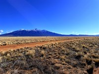
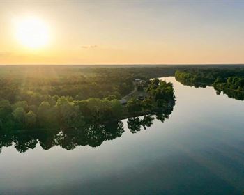
Picture this: it is the last week of June. You step outside your cabin door at 8,500 feet in the Sangre de Cristo Mountains of southern Colorado. The temperature is 68 degrees. There is no traffic noise, no sirens, no pressure to be anywhere. The only sound is the wind moving through the brush and the distant call of a red-tailed hawk circling the ridge. You have coffee in one hand and a clear view toward the 14,345-Foot summit of Mount Blanca catching the first light of morning. This is not a vacation. This is your land. This is your life.
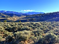
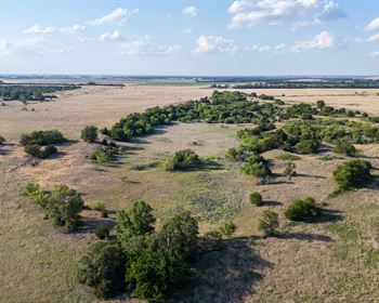
That is exactly what this 5.27-Acre parcel in the Sangre de Cristo Ranches of Costilla County, Colorado makes possible. Positioned at 8,520 to 8,550 feet above sea level on a gently sloping, lightly wooded lot with direct access from county-maintained Pfotenhauer Road, this is a genuine high-country mountain parcel with Estate Residential zoning, confirmed legal access, no mandatory HOA dues, and annual taxes of just $212.48. Less than the cost of a weekend hotel room. Every year.
This is Lot 2049, Block 126, Sangre de Cristo Ranches Unit L - a parcel measuring approximately 505 feet north-to-south and 545 feet east-to-west, set in one of southern Colorado's most established and beloved mountain land communities. The Sangre de Cristo Ranches were originally developed across more than 44,000 acres at the base of the Sangre de Cristo range. Today, county-maintained roads thread through the entire subdivision, landowners enjoy exclusive access to more than 5,000 acres of dedicated Greenbelt for hunting and recreation, and the community draws buyers from across the country - retirees escaping the summer heat of Arizona, Texas, and New Mexico; remote workers leaving the Front Range's density behind; hunters seeking a permanent base camp inside GMU 83's elk country; and investors who understand that affordable five-acre Colorado mountain land with a confirmed address and legal road access does not stay on the market at these prices indefinitely.
Whether you are building a primary residence, a retirement retreat, a seasonal cabin, a short-term rental, or simply securing a piece of the American West for your family's future - this parcel can serve that purpose. At 8,500 feet, you are above the summer heat, inside the wildlife corridor, 47 minutes from Great Sand Dunes National Park, and within reach of three ski areas. Owner financing is available with no credit check, no bank involvement, and no prepayment penalties. Your Colorado mountain ownership can begin with as little as $279 down.
A Day In The Life - Your Mountain Retreat At 8,500 Feet
You wake up before the alarm - not because you have to, but because the light coming through the cabin window is too good to sleep through. By 6:30 a.m. you are outside with coffee, watching a small group of mule deer move through the brush below the property line. The air is thin and cool. The Blanca massif is catching alpenglow on its eastern face. You did not drive here. You live here.
By 9 a.m. you are on the road - seventeen minutes to Fort Garland for gas and a diner breakfast, or forty-four minutes to Alamosa if the grocery list is long. Alamosa has everything: Walmart, Home Depot, a regional hospital, restaurants, and an airport if family is flying in. You do not feel isolated. You feel insulated.
Afternoons in summer belong to the land. A walk through the Greenbelt. A drive toward Mountain Home Reservoir for an hour of trout fishing on a quiet weekday when the reservoir is practically yours alone. In October, you are in the elk woods before first light. In late September, you are watching the aspen groves in the Culebra Range turn gold from a ridgeline you reached on an ATV in twenty minutes.
When the grandchildren visit, you take them to Great Sand Dunes National Park - 47 minutes away - where they will sprint up 750-Foot dunes and wade in Medano Creek and talk about it for the rest of their lives. When the week is quiet, you sit outside after dark and watch the Milky Way arc overhead, unobstructed, without a single source of ambient light competing with it from horizon to horizon.
This is what 8,500 feet in southern Colorado looks like when you own the land under your feet.
Property Highlights At A Glance
Parcel: Lot 2049, Block 126 - Sangre de Cristo Ranches Unit L
Apn: 70246260
Address: Pfotenhauer Rd, Fort Garland, CO 81133
County: Costilla County, Colorado
GPS Center: 37.32795, -105.35160
Parcel Size: 5.27 acres
Terrain: Gentle slope, lightly wooded, brush
Elevation: 8,520 ft - 8,550 ft above sea level
Lot Dimensions: 505 ft N / 545 ft E / 505 ft S / 320 ft W
Flood Zone: Zone C - above the 500-Year floodplain, very minimal wetlands
Road Access: Pfotenhauer Rd - dirt, county-maintained, legal direct frontage
Zoning: Estate Residential (Er), Costilla County
Permitted Structures: Single-family home, manufactured home, mobile home (post-1976), tiny home (600 sq ft min), cabin
Camping/RV: Permitted - 14 days every 3 months without installed septic
Short-Term Rentals: Permitted per county (state guidelines apply)
Annual Taxes: $212.48 - current through 2025
Back Taxes: None
Tax Liens: None
HOA / Poa: Voluntary only - Sdcr Community Association, no mandatory dues
Closest Town: Fort Garland, CO - 18 min / 12.2 miles
Closest City: Alamosa, CO - 44 min / 37.1 miles
Great Sand Dunes National Park: 47 min / 36.6 miles
Cash Sale Price: $19,999 (reduced from $25,000)
Owner Financing: From $279 down - no credit check, no bank required
Location And Access
Fort Garland - The Gateway to the San Luis Valley, 18 Minutes Away: Fort Garland sits at the intersection of US Highway 160 and Colorado Highway 159, positioned at the precise geographic threshold between the Sangre de Cristo Mountains and the broad high-desert expanse of the San Luis Valley. It is a working small town with the practical backbone a mountain landowner needs: gas stations, a post office, a grocery market, diners, and the Fort Garland Museum and Cultural Center - a restored 1858 military outpost where frontiersman Kit Carson served as commanding officer. For the size of the town, Fort Garland punches well above its weight. You are 18 minutes from it via county roads and Co-159.
Alamosa - Full-Service Regional Hub, 44 Minutes: Alamosa is the largest city in the San Luis Valley and the regional center for everything the area's rural landowners depend on. Adams State University, San Luis Valley Health regional hospital, Walmart Supercenter, Home Depot, grocery chains, multiple restaurants, specialty retail, and San Luis Valley Regional Airport (Als) - with connecting service to Denver International - make Alamosa a genuine urban resource center within a reasonable drive. For medical appointments, major supply runs, or travel connections, Alamosa covers all of it.
Pfotenhauer Road - County-Maintained Legal Access: Your parcel has direct frontage on Pfotenhauer Road, a county-maintained dirt road linking the property to Colorado Highway 159. Costilla County maintains roads throughout the Sangre de Cristo Ranches subdivision, providing year-round legal access without the dependency on private road agreements or uncontrolled easements.
Regional Highway Network: Co-159, Us-160, Co-12, and I-25 all serve the surrounding region, placing Colorado Springs 2 hours 28 minutes northeast (152 miles), Pueblo approximately 2 hours east, and Walsenburg roughly 55 minutes east via Us-160 over La Veta Pass. Taos, New Mexico is approximately 2 hours south via Co-159 and Us-64 - a genuine cultural and dining destination within day-trip range.
GPS Corner Coordinates:
Ne: 37.3283, -105.3507
Se: 37.3268, -105.3510
Sw: 37.3276, -105.3524
Nw: 37.3285, -105.3524
Center: 37.32795, -105.35160
Zoning And Permitted Uses - More Flexibility Than You Expect
Estate Residential (Er) - Costilla County's Most Flexible Rural Designation: The Estate Residential zoning classification is a genuine residential designation - not an agricultural overlay, not a conservation restriction, not a "future development" placeholder. This parcel is buildable today, under zoning that supports a wide range of residential structures and uses. No one is telling you to wait.
Single-Family Dwelling: Build a single-family home with a minimum footprint of 600 square feet. Building permits are issued for one-year terms with the ability to renew - giving you full control over your construction pace and timeline. Phase the project across seasons. Build when the budget allows. The county will work with you.
Manufactured Home or Modular Home: Quality post-1976 manufactured homes and modern modular units are permitted under both Costilla County zoning and Sdcr Cc&Rs. For buyers who want to be on their land quickly, affordably, and permanently, a manufactured or modular home is one of the most practical paths to full-time or seasonal occupancy. The mountain landscape here is no less beautiful when seen from the porch of a well-designed manufactured home.
Tiny Home or Cabin: Tiny homes are permitted with a minimum size of 600 square feet (single-story) or 800 square feet (two-story) per Sdcr Cc&Rs. The combination of a compact, well-insulated off-grid cabin and a strong solar energy system is one of the most cost-effective paths to genuine mountain living available in Colorado today.
Short-Term Vacation Rental: STRs are permitted per Costilla County, subject to current Colorado state guidelines. If you purchase this parcel as a longer-horizon investment and choose to build and rent, the short-term rental market for authentic Colorado mountain properties in proximity to Great Sand Dunes continues to see consistent demand from Front Range and out-of-state travelers.
Camping and RV Use: Camping and RV parking are both permitted. Without an installed septic system, use is limited to 14 days per 3-month period per county guidelines - entirely workable for a scouting trip, a weekend retreat, or a phased move-in while your permanent structure is under construction.
Voluntary HOA Only - No Mandatory Dues, No Enforcement Overhead: Membership in the Sangre de Cristo Ranches Community Association ( is entirely voluntary. There are no mandatory fees, no HOA assessments, and no covenant enforcement apparatus with authority over your property decisions beyond the Sdcr Cc&Rs - which are primarily structural minimums designed to protect property values across the subdivision, not to limit your freedom.
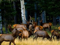
Wildlife And Hunting - Gmu 83 Elk Country
Game Management Unit 83 - Over-The-Counter Elk Licenses Available: This parcel sits within Colorado Game Management Unit 83, home to the Trinchera elk herd - one of the largest elk herds in the state with an estimated 7,000 animals. For rifle hunters, GMU 83 is exceptional: over-the-counter bull elk licenses are available for the second and third rifle seasons without a draw. No waiting years for a limited tag. Purchase your OTC license at any Colorado sporting goods retailer and head to the field. For youth hunters ages 12 to 17 with a hunter education certification, out-of-state bull licenses are available for approximately $104 - an extraordinary value for access to a herd of this size.
5,000-Acre Sdcr Greenbelt - Exclusive Landowner Hunting Access: Ownership in the Sangre de Cristo Ranches comes with access to more than 5,000 dedicated acres of community Greenbelt set aside exclusively for landowner use - open to hunting, hiking, ATV riding, horseback riding, and general recreation. As an Sdcr landowner, you have a private recreational land base that most hunters would have to pay a licensed outfitter to access. The Greenbelt includes parcels above 9,000 feet, placing some of the best elk terrain in the subdivision within reach of your property.
Mule Deer, Pronghorn, and Upland Game Birds: Beyond elk, Costilla County supports healthy populations of mule deer, pronghorn antelope, wild turkey, and grouse throughout the ridgelines and valley floors surrounding the Ranches. The 8,500-Foot elevation zone - where brush, scrub oak, and piñon-juniper transition to higher terrain - is prime habitat for deer and elk concentration during archery season in September and the early rifle seasons.
Raptors and the San Luis Valley Migration Corridor: The San Luis Valley sits beneath one of North America's premier raptor migration corridors. Golden eagles, red-tailed hawks, Swainson's hawks, and ferruginous hawks are regular sights over the Sangre de Cristo Ranches year-round. In spring and fall, the valley channels one of the continent's great sandhill crane migrations - tens of thousands of birds moving through in concentrated waves. From the higher ridgelines of the Ranches, the crane migration is a visual spectacle that wildlife photographers travel from across the country to witness.
Black Bear, Mountain Lion, Mule Deer, and Fox: The food chain operates at full capacity at this elevation. Black bear, mountain lion, bobcat, fox, and coyote complete the predator picture. For photographers, naturalists, and serious wildlife observers, the range of species visible from - or immediately adjacent to - a parcel like this one is genuinely exceptional.
Year-Round Wildlife Viewing Directly From Your Land: The gentle, open terrain - lightly wooded with brush and a gradual slope - means wildlife viewing from your own parcel is a daily reality rather than an occasional event. Mule deer browse at dawn. Bull elk move through the drainage corridors in October and November. Raptors hunt the open ground throughout the daylight hours. With a cabin here and a good pair of binoculars, the wildlife experience is not something you drive to - it is something you step outside for.
Outdoor Recreation And Nearby Attractions
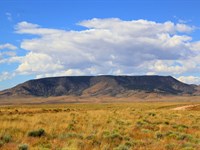
Great Sand Dunes National Park - 47 Minutes / 36.6 Miles: One of the most visually extraordinary landscapes on the continent, Great Sand Dunes National Park is home to North America's tallest sand dunes - some rising more than 750 feet - set directly against the base of the Sangre de Cristo Mountains in one of the most improbable and unforgettable collisions of landscapes anywhere in the world. The park offers sand sledding, sandboarding, seasonal wading in Medano Creek, backcountry hiking, and wildlife observation across a 150,000-Acre preserve. Great Sand Dunes is open year-round and rewards return visits in every season: wildflower blooms in spring, dramatic afternoon thunderstorm light in summer, golden grasses and crisp air in fall, and stark snowcapped dunes against winter-blue sky. For buyers who care about the long-term value anchor of their land investment, national park proximity is one of the most durable and documented location premiums available. Great Sand Dunes draws over 600,000 visitors annually - and that number grows every year.
Zapata Falls - 47 Minutes: A short detour from Great Sand Dunes, Zapata Falls is one of the San Luis Valley's finest hidden gems. The trail descends into a narrow canyon slot where a 30-foot cascade pours through polished volcanic rock - an intimate and spectacular reward for a short hike in. The access road to the trailhead delivers sweeping valley views across the San Luis that are worth the drive regardless of the destination.
Mountain Home Reservoir State Wildlife Area - World-Class Trout Fishing: Mountain Home Reservoir sits a short drive from the Sangre de Cristo Ranches and offers rainbow trout, brown trout, and cutthroat fishing in a mountain reservoir setting with the access guarantees of a State Wildlife Area. The reservoir draws fly anglers and bait fishermen from across the region. In summer it serves as the area's informal water recreation hub - boating, bank fishing, wildlife watching. In winter, ice fishing is a regular draw when conditions allow. For a landowner who plans to spend real time at a cabin on this parcel, the reservoir is a quick weekday afternoon destination with an excellent fish-to-effort ratio.
Mount Blanca - Colorado's Fourth-Highest Peak, One of the Navajo Sacred Mountains: The 14,345-Foot summit of Mount Blanca stands on the northern horizon from much of the Sangre de Cristo Ranches. One of Colorado's 58 ranked fourteeners and one of the four sacred peaks of the Diné (Navajo) Nation, Blanca commands the landscape in a way that few mountains do - massive, isolated, and immediately recognizable from any approach. Technical and non-technical summit routes via Lake Como Road and Blanca-US 160 put the peak within reach for fit hikers and experienced mountaineers. At 8,500 feet on this parcel, you are already nearly halfway up the mountain in elevation terms - you are living at altitude that most Colorado visitors only visit.
Hiking, Atv, and Off-Road Recreation - Greenbelt Plus National Forests: The Sdcr Greenbelt provides 5,000-Plus acres of backcountry terrain accessible directly to landowners. Beyond the Greenbelt, the San Isabel National Forest and Rio Grande National Forest offer hundreds of miles of trails and forest roads open to hiking, mountain biking, horseback riding, and off-road vehicle use. The Culebra Range to the south, the main Sangre de Cristo crest to the north, and the Trinchera Creek drainages threading between them collectively create a recreational landscape that takes years - literal years - to fully explore.
Skiing - Three Areas Within Two Hours: Wolf Creek Ski Area, consistently ranked among Colorado's top destinations for natural snowfall and authentic ski terrain, sits approximately two hours to the west over Wolf Creek Pass. Monarch Mountain - a beloved classic Colorado ski area known for uncrowded runs, reasonable prices, and genuine mountain character - is about 1.5 hours to the north. Cuchara Valley Resort, a boutique ski area in the Culebra Range to the east, is approximately one hour away - a quick day trip that avoids the highway congestion of larger Colorado ski resorts entirely.
Fort Garland Museum and Cultural Center - 17 Minutes: Housed in the original 1858 military outpost at 29477 Co-159, the Fort Garland Museum operates as a Colorado History Museum site and chronicles the military, cultural, and frontier history of the San Luis Valley with reference to Kit Carson's command. For history enthusiasts and retirees who appreciate the layered story of the American West, this is a destination worth multiple visits.
San Luis - The Oldest Incorporated Town in Colorado - 25 Minutes: Founded in 1851, San Luis predates Colorado statehood by twenty-five years. The town is home to the Stations of the Cross Shrine - a bronze sculpture trail culminating at a hilltop chapel with sweeping valley views - local Hispano cuisine, and a cultural depth rooted in land-grant traditions going back to the Spanish colonial period. It is one of the most distinctive small towns in the Rockies and a rewarding destination for anyone willing to get off Us-160 and explore.
Colorado Alligator Farm and Natural Hot Springs: The Colorado Gator Farm near Mosca - a working tilapia aquaculture facility heated by natural geothermal springs - operates as one of southern Colorado's most unusual and memorable attractions. Live alligators, hot spring swimming, snorkeling, and a distinctly Colorado-weird experience that visitors remember for decades. Located approximately 50 minutes from the property.
Dark Sky Stargazing - Costilla County International Dark Sky Designation: Costilla County and the surrounding San Luis Valley benefit from some of the lowest light pollution levels available in the continental United States. The San Luis Valley Dark Sky region offers unobstructed views of the Milky Way on clear nights, with the high elevation, dry air, and minimal development creating astronomical conditions that rival designated observatory sites. On a clear night at 8,500 feet on this parcel, the Milky Way is not a faint suggestion - it is a river of light crossing the full sky from horizon to horizon.
Utilities And Off-Grid Living - Built For Energy Independence
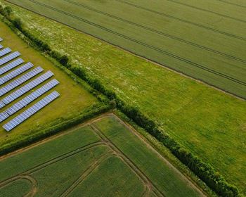
Power - Off-Grid Solar: The Premier Option at This Location: There are no visible power poles near this parcel. Grid connection via Xcel Energy ) is possible but would require line extension at the buyer's expense. The practical and economically superior path at this elevation and location is an off-grid solar system - and the conditions here are exceptional. The San Luis Valley is one of the highest solar irradiance zones in the United States. Over 300 days of sunshine annually, high elevation, and clear mountain air combine to create a solar resource that commercial energy developers have recognized for years - multiple utility-scale solar installations in the valley attest to the quality of the resource. A properly designed residential solar array with battery storage powers a fully equipped cabin or manufactured home reliably across all four seasons. Wind generation provides a supplemental resource during seasonal storm periods. A propane-fueled generator rounds out the backup picture for extended cloud periods.
Water - Domestic Well Permit: Water at this elevation requires either a domestic well or water hauling to a holding tank or cistern. The Colorado Division of Water Resources issues domestic household well permits for the Sangre de Cristo Ranches area. A licensed well driller familiar with local geology in the Sdcr service area is your best resource for depth estimates and flow rate projections specific to this parcel's location. Water hauling combined with a holding tank is a common interim solution used by landowners throughout the subdivision while a permanent well is being permitted and installed.
Sewer - Conventional Septic System: A conventional septic system is required for any permanent occupancy or to extend camping and RV use beyond the 14-day county limit. Costilla County's planning and zoning department handles septic permits and can direct you to approved system designers for this soil type and elevation range. Leach field designs are standard at this elevation. Septic permitting is a known, manageable cost that most buyers budget independently of their primary dwelling construction timeline.
Propane - Heating and Cooking: Propane is the standard fuel for heating, hot water, and cooking throughout the Sangre de Cristo Ranches and the surrounding Costilla County area. A-1 High Valley Propane serves the area and can be reached at. Buried propane tank installation is a standard project completed by landowners throughout the subdivision, and delivery logistics are well-established for the Sdcr service area.
Internet - Starlink Satellite Broadband: Starlink satellite internet delivers genuine broadband speeds across the entire San Luis Valley without requiring any physical infrastructure at the parcel level. At 8,500 feet with unobstructed sky exposure, Starlink performance is consistent and reliable year-round. For retirees who need to stay connected to family, remote workers maintaining client relationships from the mountains, and investors monitoring their portfolio from a cabin with a mountain view - Starlink has fundamentally changed what is possible on off-grid parcels. You are not choosing between connectivity and solitude. You can have both.
Waste Removal: Waste management requires a private hauler or periodic trips to the nearest county convenience center - standard practice for off-grid rural parcels throughout Costilla County and routinely managed by the majority of active Sdcr landowners without difficulty.
Climate And Terrain - Why 8,500 Feet Changes Everything
The Elevation Advantage - Cool Summers When the Rest of the Country Burns: Eight thousand five hundred feet changes the experience of summer in ways that are difficult to convey to someone who has not spent a July in the high country. While Phoenix reaches 115 degrees and Dallas bakes at 103 and even Denver climbs into the low 100s during heat waves, this parcel sits at an altitude where afternoon highs in June, July, and August typically top out in the mid-70s Fahrenheit - with nights dropping comfortably into the 40s. Air conditioning is not a feature of mountain cabins at this elevation because it is not needed. This is the reason the Sangre de Cristo Ranches have consistently drawn retirees from Arizona, New Mexico, Texas, and Southern California for decades: when the places you live in become genuinely unpleasant in summer, Colorado mountain land at 8,500 feet becomes very attractive indeed.
Summer - Long Days, Active Skies, and Peak Outdoor Access: June through August is the core season for construction activity, extended stays, outdoor recreation, and the full enjoyment of what this parcel offers. Afternoon convective thunderstorms build regularly in July and August - dramatic cells that tend to move through in under an hour and leave the air remarkably clean in their wake. The smell of rain on sage and piñon at this elevation is one of the defining sensory memories of the American mountain West.
Fall - Elk Season, Aspen Color, and the Best Conditions of the Year: September and October deliver the most concentrated season of activity in the Sangre de Cristo Ranches. Archery elk season opens in early September. Rifle seasons run through October into November. The aspen groves in the Culebra Range and along the upper drainages above the subdivision erupt in gold and orange during the last two weeks of September - a color display visible from ridgelines across the community. Fall mornings at 8,500 feet are cold, clear, and quiet in a way that mountain people return to every year without explanation.
Winter - Snow, Quiet, and a Different Kind of Value: Winter brings snow and cold to the Sangre de Cristo Ranches, with primary county-maintained roads plowed regularly and upper subdivision roads occasionally requiring four-wheel drive after significant snowfall. Many Sdcr landowners use winter as a planning and procurement season - finalizing cabin designs, ordering materials, and arriving in spring ready to build. For buyers who snowshoe, snowmobile, or ice fish, winter carries its own recreational value. Wolf Creek and Monarch are both within driving distance.
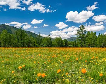
Spring - Wildflowers and Green: April and May bring rapid, vivid transition at this elevation - snowmelt fuels wildflower blooms across the lower slopes of the subdivision, and the full green flush of early summer arrives in compressed, concentrated form. After the quiet of winter, spring on mountain land feels like a genuine renewal.
Terrain and Flood Risk: The parcel features a gentle slope with light woodland cover and brush - not a drainage-carved ravine, not a cliff face, not a flat-bottom irrigation field. Lot dimensions of approximately 505 feet north-to-south and 545 feet east-to-west provide substantial building envelope flexibility across the length of the parcel. Flood Zone C classification confirms the property is above the 500-Year floodplain with very minimal wetland presence - a clean, unencumbered risk profile for both construction financing purposes and long-term land use planning.
Solar Resource: The San Luis Valley holds one of the highest solar irradiance measurements in the continental United States. The combination of high elevation, low humidity, southern Colorado latitude, and over 300 annual sunshine days creates a solar energy environment where an off-grid system sized correctly for a residential cabin performs at or above capacity consistently across all four seasons.
Community And Services
Fort Garland - 18 Minutes North: Fort Garland is a no-nonsense western town with everything a mountain landowner needs day-to-day: gas, groceries, a post office, diners, and the Fort Garland Museum. Nothing pretentious, nothing unnecessary - it is the practical backbone of rural life in the southern Sangre de Cristo Ranches, and it delivers.
Alamosa - 44 Minutes West: The full-service anchor of the San Luis Valley. San Luis Valley Health hospital covers serious medical needs. Adams State University adds an educated, active community character to the city. Walmart, Home Depot, multiple grocery options, and restaurants covering a wide range of cuisines make Alamosa a genuine regional hub. San Luis Valley Regional Airport (Als) offers connecting service to Denver International - useful for landowners traveling frequently or expecting family to fly in.
San Luis - 25 Minutes South: The oldest incorporated town in Colorado, established 1851. Hispano culture, the Stations of the Cross Shrine, local eateries, and a community identity unlike anything else in the Rockies. A worthwhile and rewarding regular destination for anyone living or spending extended time in the area.
La Veta and Walsenburg - East Over La Veta Pass: La Veta is a small arts community tucked beneath the Spanish Peaks - about 45 minutes east over La Veta Pass. Walsenburg, the Huerfano County seat, sits another 15 minutes beyond La Veta on I-25. Both towns offer additional services, dining, and the scenic drive over La Veta Pass (9,413 feet) that is worth making for its own sake.
Schools: Sierra Grande School District R-30 serves the Fort Garland area, providing K-12 education for families who intend to establish a primary residence on this parcel.
Emergency Services: Costilla County Sheriff's Department covers the unincorporated areas including the Sangre de Cristo Ranches. Fire and emergency services are available from Fort Garland. At these distances and elevations, prepared, self-reliant landowners are a standard feature of the Sdcr community - basic first-aid supplies and weather preparedness are part of mountain life here, as they are throughout the rural West.
Community Character: The Sangre de Cristo Ranches community spans hunters, retirees, remote workers, outdoor enthusiasts, and long-term land investors - landowners who share a common orientation toward open space, wildlife, mountain terrain, and the quiet that distance from urban density alone can provide. The voluntary POA maintains a community web presence at with road updates, community news, and general area resources.
The Investment Case - Why This Land Holds And Appreciates
The Lowest Carrying Cost in Colorado Mountain Land: Annual property taxes of $212.48 are an extraordinary figure for a 5-acre mountain parcel in Colorado. No mandatory HOA dues. No special assessments. No utility bills on vacant land. Your total annual holding cost - taxes plus a minimal liability policy - comes to well under $300 per year. In a state where mountain real estate in comparable locations typically carries property tax burdens in the thousands annually, Costilla County is in a different category entirely. The cost to wait while the land appreciates is essentially zero.
Finite Supply, Growing Demand: The Sangre de Cristo Ranches is a fixed subdivision. The lots exist. No new inventory is being created. Demand for rural Colorado land has accelerated steadily over the past several years, driven by Front Range population growth, the normalization of remote work, the increasing unaffordability of traditional mountain real estate markets, and the growing recognition that rural Costilla County parcels represent one of the last affordable entry points into genuine Colorado mountain land. Five-acre lots with confirmed legal road access, residential zoning, and proximity to a national park are exactly what that growing buyer pool is looking for - and there are only so many of them.
National Park Proximity as a Long-Term Value Anchor: Great Sand Dunes National Park, 47 minutes from this parcel, draws more than 600,000 visitors annually and continues to grow its national profile. Properties within one hour of a major national park carry a measurable structural premium over comparable properties outside that radius - a phenomenon documented in virtually every national park market in the country. That premium is already present here, and it is not diminishing.
The Off-Grid Solar Dividend: As energy independence becomes both a lifestyle priority and an economic hedge, off-grid-capable mountain land gains a preference premium over grid-dependent alternatives. The San Luis Valley's status as one of the nation's premier solar resource areas is not incidental to this parcel's value - it is foundational to the economics of building here. The infrastructure that makes this property livable without a utility connection is already priced into the landscape. You are buying access to a natural energy advantage.
Multiple Exit Strategies - Maximum Flexibility: Build and occupy as a primary residence. Build and use as a seasonal mountain retreat. Build and operate as a short-term vacation rental. Hold vacant at minimal cost while the land appreciates. Exchange into another property in our portfolio. Combine with an adjacent parcel for expanded acreage. The Estate Residential zoning and Costilla County's progressive rural regulations ensure that your options remain open over time rather than narrowing with each passing year.
The Long Trend Line Points One Direction: Colorado's population growth, driven by sustained in-migration from higher-cost states, continues to compress affordable land options on the Front Range and in established mountain resort markets. The San Luis Valley has absorbed some of that demand and will absorb more. The remote work transformation has expanded the universe of buyers who can actually live on mountain land full-time - not just vacation on it. The retiree demographic from the Sun Belt states that has historically driven seasonal demand for Sdcr properties continues to grow. All of these trends point in the same direction. The time to acquire affordable Colorado mountain acreage is before these dynamics become fully reflected in asking prices.
Your Three Paths To Ownership - No Credit Check, No Bank Required
We have built three ownership paths designed for real buyers with real financial lives. No credit check. No bank approval. No lengthy application process. Choose what fits your situation.
Option 1 - Cash Purchase
Best Total Value - Immediate Full Ownership
Cash Sale Price: $19,999 (reduced from $25,000)
Down Payment: $500
Documentation Fee: $249
Total Due Today: $749
Conveyance: Recorded Warranty Deed delivered after closing
Save the most. Own it outright. Done in 1-2 business days.
---------------------------------------------------------------
Option 2 - Super Saver Financing
Best Value With Financing - Fastest Path to Full Ownership
Monthly Payment: $531.71
Loan Term: 3.5-Year Super Saver Plan
Total Monthly Payments: $499 x 42 months
Down Payment: $499
Documentation Fee: $249
Total Due Today: $748
Own your Colorado land free and clear in 3.5 years.
---------------------------------------------------------------
Option 3 - Easy Financing
Lowest Entry Point - Maximum Monthly Flexibility
Monthly Payment: $309
Loan Term: 7-Year Easy Financing Plan
Total Monthly Payments: $279 x 84 months
Down Payment: $279
Documentation Fee: $249
Total Due Today: $528
Get started for $528. Own Colorado mountain land for less than a monthly car payment.
No pre-payment penalty to pay off early.
All Three Plans Include:
No Credit Check - Your credit history does not determine your access to Colorado mountain land.
No Bank Involvement - No applications, no appraisals, no underwriting delays, no denials.
No Prepayment Penalties - Pay your balance off early at any time, at zero additional cost.
Simple Paperwork - We handle it. Ownership transfers in one to two business days from reservation.
How It Works - Four Steps To Your Colorado Land
Step 1 - Explore: Read this listing thoroughly. Every section exists to give you a complete, honest picture of this parcel - terrain, zoning, utilities, recreation, investment case, and financing. Use Google Maps satellite view at 37.32795, -105.35160 to visually walk the parcel before you drive.
Step 2 - Visit: Pull up the GPS coordinates and drive to the property. Walk Pfotenhauer Road. Step onto the parcel. Stand on the slope, look north toward the Blanca massif, and take in the elevation and the quiet. This is land that earns its asking price when you stand on it.
Step 3 - Choose Your Path: Cash ($749 total due today), Super Saver ($748 due today), or Easy Finance ($528 due today). Pick the option that fits your budget and timeline.
Step 4 - Make It Official: Reserve online or by phone. We handle all paperwork, coordinate the title process, and record the deed. Most transactions complete within one to two business days. Your 100-Day No-Nonsense Guarantee is active from the moment your down payment clears.
Take Action - This Is Where Your Colorado Story Begins
What You Are Getting: 5.27 acres in the Sangre de Cristo Ranches of Costilla County, Colorado. Gentle slope, lightly wooded, at 8,520 to 8,550 feet above sea level. Estate Residential zoning with the freedom to build a cabin, manufactured home, tiny home, or full residence on your timeline. Direct frontage on county-maintained Pfotenhauer Road. No mandatory HOA dues. No back taxes. No liens. Annual taxes of $212.48. Access to 5,000-Plus acres of landowner Greenbelt in GMU 83 elk country. Great Sand Dunes National Park 47 minutes away. Mountain Home Reservoir trout fishing a short drive from your door. Starlink-ready off-grid solar country. Three ski areas within two hours. And owner financing from $279 down - no credit check, no bank required.
Why This Will Not Wait: Five-acre mountain parcels in the Sangre de Cristo Ranches at 8,500 feet, with confirmed legal road access and Estate Residential zoning, at this price point represent a diminishing inventory category. Costilla County land values have moved consistently upward as Front Range buyers, out-of-state retirees, and remote workers have discovered the value embedded in this market. Today's asking price reflects a window that is narrowing. When that window closes, it will not reopen at the same price.
Your Next Move: Review the listing once more. Drop the GPS into your maps. Drive out on your next available day off. Stand on the land. Listen to the quiet. Look north at the mountain. Then call us, pick your option, and make it yours.
100-Day No-Nonsense Guarantee
When you purchase this property and change your mind within 100 days of your down payment, let us know. We will either refund your principal payment or exchange it for another property in our inventory that better suits your needs. This guarantee allows you to secure the property confidently before visiting in person. On owner financing, we refund principal paid excluding fees (closing costs, doc fees, note maintenance fees, and taxes). Any late or missed payments during the guarantee period will automatically void the guarantee.
The morning is cool. Mount Blanca catches the first light. The coffee is hot. The land is yours.
Start living wild - your Colorado mountain adventure begins today.
Land Maps & Attachments
Directions to Land
Directions To Apn 70246260
Pfotenhauer Rd, Fort Garland, CO 81133
GPS Center: 37.32795, -105.35160
Sangre De Cristo Ranches Unit L, Block 126, Lot 2049
PRIMARY STARTING POINT - FORT GARLAND, CO (18 min / 12.2 miles)
1. Start at the intersection of US-160 and CO-159 in Fort Garland, Colorado.
2. Head SOUTH on CO-159 (toward San Luis) for approximately 10 miles.
3. Turn LEFT (east) onto Pfotenhauer Road. (Watch for the road sign on the east side of CO-159.)
4. Continue east on Pfotenhauer Road for approximately 1.5 to 2 miles.
5. Lot 2049 (Block 126) will be on your right (south side of Pfotenhauer Road).
6. Confirm arrival using GPS: 37.32795, -105.35160
Note: Pfotenhauer Road is a county-maintained dirt road. Passable under normal conditions with a standard passenger vehicle. A high-clearance vehicle is recommended after heavy rain or snow. If road conditions appear questionable, wait for dry conditions before proceeding.
SECONDARY STARTING POINT - ALAMOSA, CO (44 min / 37.1 miles)
1. Start in Alamosa, Colorado. Head EAST on US-160 toward Fort Garland for approximately 35 miles.
2. Shortly after passing through Blanca, continue east on US-160.
3. At Fort Garland, turn RIGHT (south) onto CO-159.
4. Head SOUTH on CO-159 for approximately 10 miles.
5. Turn LEFT (east) onto Pfotenhauer Road.
6. Continue east approximately 1.5 to 2 miles to Lot 2049 on your right.
7. Confirm: 37.32795, -105.35160
SECONDARY STARTING POINT - WALSENBURG / I-25 CORRIDOR (approx. 55 min)
1. From Walsenburg, head WEST on US-160 over La Veta Pass toward Fort Garland (approximately 44 miles).
2. Continue through La Veta and over La Veta Pass (elevation 9,413 ft) - the drive over the pass is scenic and typically open year-round.
3. Descend into Fort Garland. At the US-160 / CO-159 intersection, turn LEFT (south) onto CO-159.
4. Head SOUTH on CO-159 for approximately 10 miles.
5. Turn LEFT (east) onto Pfotenhauer Road.
6. Continue east approximately 1.5 to 2 miles to Lot 2049 on your right.
7. Confirm: 37.32795, -105.35160
Gps Corner Coordinates For Navigation
Center: 37.32795, -105.35160
NE Corner: 37.3283, -105.3507
SE Corner: 37.3268, -105.3510
SW Corner: 37.3276, -105.3524
NW Corner: 37.3285, -105.3524
Nearby Fuel And Services
Closest Gas Station: High Altitude Convenience, 316 Miranda Ave, Fort Garland, CO 81133 - approximately 17 min / 11.9 miles north via CO-159.
Fuel up in Fort Garland before heading south on CO-159. Service stations are not available along the CO-159 corridor south of Fort Garland.
More Land Details
More Land from Collin Pettet
 5.1 AC : $15K
- 1.7 AC : $20K
- 5.7 AC : $10K
- 5.6 AC : $8.5K
- 0.2 AC : $9K
- 0.2 AC : $9K
- 5.1 AC : $8.5K
- 1 AC : $8.5K
- 1.6 AC : $9K
- 0.2 AC : $9K
- 5.4 AC
- 1 AC : $8.5K