AZ Double Lot RV Setup Dual Access
Access Via Hickory Ln & Chestnut Ln : Concho, AZ 85924
Apache County, Arizona
Land Description
2.08 Acres Near Concho Lake, Az - Dual Road Access, Power Nearby, Rv-Ready
APNs: 201-28-071 and 201-28-122. Apache County, Arizona. Two adjoining parcels of 1.04 acres each.
Own Two Adjoining Acres Outside Concho, Arizona - With Road Access On Both Sides
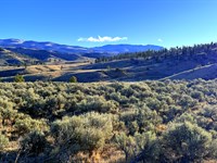
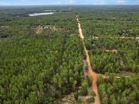
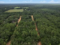
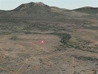
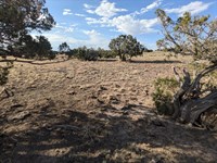
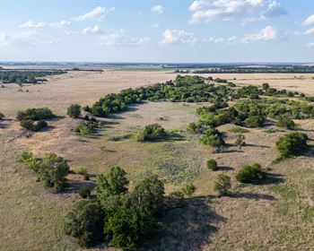
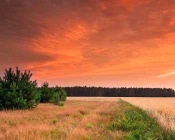
This is a rare double-lot opportunity in the SW section of Concho Valley Unit 2. Two adjoining 1.04-Acre parcels totaling 2.08 acres, just minutes from the south shore of Concho Lake. The town of Concho sits on the north side of the lake, putting you within easy reach of essentials while keeping you in the open, off-grid country that draws RVers, retirees, and outdoor families to this corner of Arizona.
What makes this listing different: road access on both sides of the combined parcel via County Road 5076 and adjoining county roads, power available nearby (Navopache Electric servicing the area), and no HOA, no time limit to build. Whether you are parking an RV for the season, building an off-grid cabin, or holding land while values appreciate, this property is ready.
Property At A Glance
Total Acreage: 2.08 acres (two adjoining 1.04-Acre parcels)
APNs: 201-28-071 and 201-28-122
Subdivision: Concho Valley Unit 2
County and State: Apache County, Arizona
Zoning: AR (Agricultural Residential)
Terrain: Gently sloping, level building areas
Access: Dual road access, county-maintained dirt roads
HOA: None
FEMA Flood Zone: Outside flood hazard areas
Power: Available nearby (Navopache Electric)
Water: Well or cistern permitted
Sewer: Septic system allowed
Internet: Starlink and cellular service (Verizon, T-Mobile)
Location And Distances
Concho, AZ: about 15 minutes (8 miles). Gas, post office, local services.
St. Johns, AZ: about 30 minutes (22.6 miles). Apache County seat, full grocery, restaurants, medical clinic.
Show Low, AZ: about 37 minutes (30.3 miles). Regional hub with hospital, Walmart, Home Depot, Lowe's, RV service, propane.
Phoenix Sky Harbor Airport: about 3.5 hours. International flights, urban amenities.
Closest highway: Az-61
Closest gas station: Jiffy Store, about 12 minutes (5.2 miles)
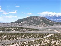
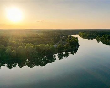
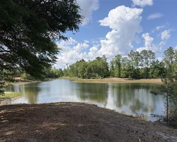
Concho Lake And The Local Area
Concho Lake sits just to the north of the property, with the town of Concho on the far shore. The lake is a quiet, locals-favorite spot for trout fishing, paddling, kayaking, and lakeside picnics. It is stocked seasonally and fishes well from spring through fall. Sunrise and sunset over the water are some of the best in the region, and the surrounding country is open enough for stargazing once night falls.
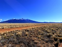
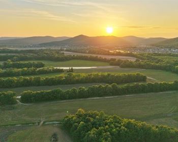
Beyond Concho Lake, the surrounding country is full of high-desert and mountain recreation. Lyman Lake State Park is roughly 25 minutes away, with full-service camping, boating, swimming, year-round trout and bass fishing, and one of the few Arizona state parks where you can swim and use motorized boats. Petrified Forest National Park, with the Painted Desert badlands and ancient fossilized logs, is under an hour. The Apache-Sitgreaves National Forest covers more than 2 million acres of public land for hiking, hunting, dispersed camping, and wildlife viewing.
Closer-in attractions from the DD report include Beaver Dam Wash Bridge, Dido Canyon, and Agate House, all within 30 to 45 minutes.
Show Low, Arizona: 37 Minutes (30.3 Miles) To The Full Regional Hub
Show Low is the largest town in the White Mountains region and the regional center for everything you cannot get in Concho or St. Johns. Sitting at about 6,400 feet elevation, it offers four real seasons, a vibrant outdoor culture, and a population of around 12,000.
Things you can do in and around Show Low:
Show Low Lake. A 100-Acre stocked lake just south of town. Excellent rainbow trout fishing, walleye and bass, with a marina, boat launch, picnic areas, and a campground. Open year-round, including ice fishing in winter.
Fool Hollow Lake Recreation Area. An Arizona State Park inside the city limits with 150 acres of water, full-hookup camping, swimming beaches, paddleboarding, kayaking, and some of the best trout fishing in the area.
Pintail Lake and Redhead Lake. Wetland reserves a few minutes from town. World-class waterfowl viewing and birding, with bald eagles, herons, ducks, and migratory species. Boardwalks and viewing platforms make it accessible.
Show Low Bluff Trail. A scenic in-town hiking trail with overlooks of the Mogollon Rim and panoramic White Mountains views.
Hawley Lake, Big Lake, and the White Mountain Lakes. A network of more than a dozen high-mountain lakes within 30 to 90 minutes of Show Low, all stocked, all good for fishing, paddling, and lakeside camping. Many are accessible by paved road.
Sunrise Park Resort. A full ski and snowboard resort about 75 minutes from Show Low. Three mountains, 65 trails, and one of the largest ski areas in Arizona. Mountain biking and lift-served downhill in summer.
Apache-Sitgreaves National Forest Trails. Hundreds of miles of hiking, mountain biking, Atv, and horseback trails accessible from Show Low. The Mogollon Rim, one of the most dramatic landforms in the Southwest, is just to the north.
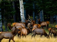
Hunting. The White Mountains are legendary for elk, mule deer, pronghorn antelope, turkey, and waterfowl. Show Low is a major staging town for hunters during fall seasons.
Restaurants, Breweries, and Shopping. Show Low has a solid restaurant scene, local breweries, a Walmart Supercenter, Home Depot, Lowes, Safeway, and full automotive and RV service. Summit Healthcare Regional Medical Center provides 24/7 emergency care, surgery, and specialist services.
Show Low Card Game Monument. A small but iconic local landmark commemorating the card game that gave the town its name.
The Wider White Mountains Region
The Concho property puts you within easy reach of one of Arizona's most underrated outdoor regions. The White Mountains run east from Show Low through Pinetop-Lakeside, McNary, and Greer, climbing into pine and aspen forests and topping out above 11,000 feet at Mount Baldy. The area gets real winters with snow, real summers with monsoon afternoon thunderstorms, and some of the best fall color in the Southwest.
Other regional draws include the Little Colorado River for fly fishing, Greens Peak fire lookout, Sipe White Mountain Wildlife Area for wildlife photography, and the Coronado Trail Scenic Byway running south from Springerville for one of the most spectacular drives in the country. Round Valley (Springerville and Eagar) is about 45 minutes east and offers more shopping, restaurants, and historic sites including Casa Malpais Pueblo.
For paved-road day trips, the South Rim of the Grand Canyon is around 4 hours, Sedona about 3 hours, and Albuquerque, NM around 4 hours.
What You Can Do Here
Build a Home or Cabin. Each 1.04-Acre parcel allows a single-family dwelling, mobile home, or manufactured home. Septic-permitted. Solar or grid power both viable.
Park Your RV. RV use is allowed up to 30 days per year without a permit. Longer-term RV use is permitted with septic installed and an RV Dwelling Permit. Dual road access makes pulling in and out with a trailer simple. No narrow easements, no neighbor bottlenecks.
Camp. Up to 30 days per year without a permit. Longer stays available with a camping permit from Apache County.
Hold as an Investment. No HOA dues. Apache County property taxes are roughly $16.52 per parcel annually, about $33 per year combined. No build deadlines. Land in this region has been seeing steady demand from RV travelers, off-grid families, and remote workers escaping the cities.
Run a Multi-Lot Setup. Because you are getting two parcels, you can build on one and keep the other for guests, an RV pad, a workshop, animals, or future resale. Each parcel can hold its own dwelling under AR zoning.
Why Concho Valley
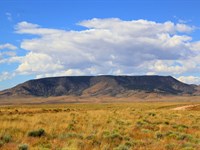
Concho sits at roughly 6,300 ft elevation in the high desert of east-central Arizona. Four real seasons, mild summers, light winters, and some of the clearest night skies in the state. The community is quiet, rural, and self-reliant by tradition, with a strong RV and off-grid retiree population. You are far enough from the cities to actually escape them, but close enough to St. Johns and Show Low that emergency services, groceries, and medical care are within a reasonable drive.
This is not a packed subdivision lot. The parcels around you are large, the dirt roads are county-maintained, and the views open up across the valley. If you have been looking for room to breathe, this is what that looks like.
Ownership Options
Three flexible plans designed around how you want to own. Pick the one that fits.
Cash Purchase: $14,900
Cash Price: $14,900
Down Payment to Reserve: $359
Documentation Fee: $249
Total Due Today: $558
Balance due at closing
Recorded Warranty Deed at closing, clear immediate title
SUPER Saver Financing: $559.11 per month (Best Value)
2.5-Year Plan: $546 x 30 months
Down Payment: $546
Documentation Fee: $249
Total Due Today: $745
Pay off the land in just 2.5 years
No credit check, no bank, no prepayment penalty
EASY Financing: $272.11 per month (Lowest Monthly)
6-Year Plan: $259 x 72 months
Down Payment: $259
Documentation Fee: $249
Total Due Today: $508
The most affordable monthly entry point
No credit check, no bank, no prepayment penalty
All three plans deliver the same property. Pick the one that fits your budget and timeline.
Annual Ownership Costs (Transparent)
Annual property taxes: about $33 total (both parcels combined)
HOA dues: $0, no HOA
Special assessments: None
Road maintenance fees: None, county-maintained
Property management fees: None
Create A Legacy With Confidence: Our 100-Day No-Nonsense Guarantee
Here at Wild Domain, our mission is simple. Give folks a fair shot at owning land, with a plan that fits like a well-worn glove. We tailor every deal to meet your needs.
Maybe you are looking for a quiet place to unwind, a spot to build your off-grid dream, or just a smart way to park your money where the world cannot touch it. Whatever the reason, we have got land that will pull its weight in your portfolio.
And you will not be riding blind. Our 100-Day No-Nonsense Guarantee means you have got time to walk the land, feel it under your boots, and make sure it is right. If it is not, we will make it right.
That is the Wild Domain way. Straight talk, solid ground.
Reserve This Property Today
Two adjoining acres in Apache County with dual road access and power nearby do not come up often at this price point. Visit our website, call us, or message directly through LandFlip to lock this in.
Wild Domain Land, LLC
Land Maps & Attachments
Directions to Land
Directions To Property
APNs: 201-28-122 + 201-28-071
Concho Valley Unit 2, Apache County, AZ 85924
Gps: 34.437148, -109.608426
---
FROM SHOW LOW, AZ (Approx. 37 miles / 37 minutes)
1. Head east on AZ-260 E / White Mountain Blvd out of Show Low.
2. Continue on AZ-260 E for approximately 8 miles, then turn LEFT (north) onto AZ-61 N toward Concho.
3. Follow AZ-61 N for approximately 22 miles through the open high desert - you'll pass through Vernon and continue into the Concho Valley area.
4. Turn RIGHT onto County Road 5076 (dirt road). Look for the county road marker on your right.
5. Continue on County Road 5076 for approximately 0.5 miles.
6. The property (2.08 acres, two adjoining lots) will be on your LEFT. Use GPS coordinates 34.437148, -109.608426 to pinpoint the exact location on your device.
---
FROM ST. JOHNS, AZ (Approx. 30 miles / 30 minutes)
1. Head west on US-180 W / Cleveland St out of St. Johns.
2. After approximately 4 miles, turn LEFT (south) onto AZ-61 S toward Concho.
3. Follow AZ-61 S for approximately 20 miles into the Concho Valley area.
4. Turn LEFT onto County Road 5076 (dirt road). Look for the county road marker on your left.
5. Continue on County Road 5076 for approximately 0.5 miles.
6. The property will be on your LEFT. Use GPS coordinates 34.437148, -109.608426 to confirm your location.
---
FROM HOLBROOK, AZ (Approx. 1 hour / 55 miles)
1. Head east on I-40 E for approximately 12 miles.
2. Take Exit 311 toward Concho / St. Johns onto US-180 E.
3. Follow US-180 E for approximately 30 miles southeast.
4. Turn RIGHT (south) onto AZ-61 S toward Concho.
5. Follow AZ-61 S for approximately 8 miles.
6. Turn LEFT onto County Road 5076 (dirt road).
7. Continue approximately 0.5 miles. The property will be on your LEFT. Confirm with GPS: 34.437148, -109.608426.
---
FROM PHOENIX, AZ (Approx. 3.5 hours / ~200 miles)
1. Head east on US-60 E out of Phoenix through the East Valley.
2. Continue on US-60 E through Globe and Show Low direction - approximately 180 miles.
3. At Show Low, merge onto AZ-260 E and continue east approximately 8 miles, then turn LEFT (north) onto AZ-61 N toward Concho.
4. Follow AZ-61 N for approximately 22 miles.
5. Turn RIGHT onto County Road 5076 (dirt road).
6. Continue approximately 0.5 miles. Property is on your LEFT. GPS: 34.437148, -109.608426.
---
Important Notes For Visiting:
- County Road 5076 is a dirt road maintained by Apache County. A standard vehicle can typically access the property, but high-clearance is recommended after rain.
- Always verify your approach using the GPS coordinates provided: 34.437148, -109.608426.
- Cell service may be limited in parts of the Concho Valley - download an offline map before heading out.
- The property has no physical address marker - use GPS and the county road number to locate the lots.
- Best visited during daylight hours for accurate lot identification.
For questions, contact us before your visit.
More Land Details
More Land from Collin Pettet
 5.1 AC : $15K
- 1.7 AC : $20K
- 5.7 AC : $10K
- 5.6 AC : $8.5K
- 0.2 AC : $9K
- 0.2 AC : $9K
- 5.1 AC : $8.5K
- 1 AC : $8.5K
- 1.6 AC : $9K
- 5.4 AC
- 0.2 AC : $9K
- 1 AC : $8.5K