6.25 Acres 9000 Ft Off Grid View
4650 Yamaha Road : Fort Garland, CO 81133
Costilla County, Colorado
Land Description
Land Description
There is a version of life that does not require permission.
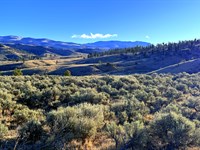
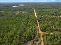
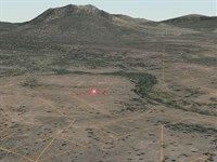
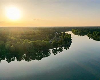
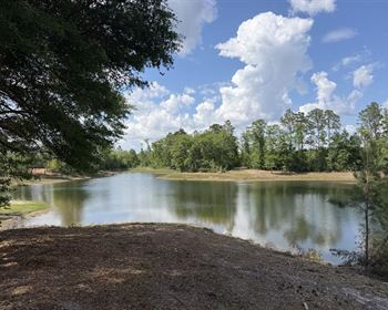
No HOA telling you what you can build, when you can build it, or how it has to look. No grid connection to maintain. No utility bill arriving every month to remind you how dependent you are on infrastructure you do not own. No neighbors close enough to notice your comings and goings. At 8,998 feet in the Sangre de Cristo Mountains, this 6.25-Acre parcel on Yamaha Road in Costilla County operates on its own terms - and so will you.
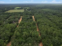
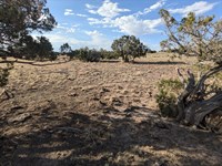
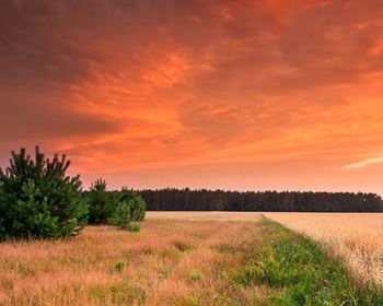
This is the highest-elevation parcel in this portfolio. Nearly 9,000 feet above sea level, sloped mountain terrain, 6.25 acres of Sangre de Cristo mountain land in the largest privately developed mountain subdivision in Colorado. The elevation alone changes the experience: cooler summer temperatures that make outdoor living comfortable without mechanical cooling, deeper winter character, darker night skies, cleaner air, and the psychological distance from the valley floor and everything it represents that makes the view from up here feel earned.
The parcel covers approximately 437 x 780 feet across a sloped mountain footprint - more total usable terrain than a flat rectangle of identical acreage, because the contour of the land creates natural site selection for a structure, natural drainage, natural privacy orientation. You choose where on the 6.25 acres to place yourself and your plans. The zoning is Estate Residential, buildable for a single-family home, manufactured home, modular, or interim camping and RV use while you develop your approach. No time pressure. No mandatory improvement. No one reviewing your plans but the county.
No electricity is available in this area from the grid - this parcel is off-grid by design, not by limitation. At 8,998 feet in the southern Rocky Mountains, solar generation is not a compromise. It is the superior solution. The sun angle, the clear sky fraction, and the solar irradiance at this elevation are exceptional. A well-designed solar array with battery storage and a propane backup gives you power that does not depend on a utility's maintenance schedule, rate hikes, or outage windows. Many full-time residents of the Sangre de Cristo Ranches at this elevation have operated entirely off-grid for decades.
Fort Garland is 14 minutes away for fuel, supplies, and the Fort Garland Museum. Mountain Home Reservoir is under 15 minutes for trout fishing and camping. Great Sand Dunes National Park - International Dark Sky Park, tallest dunes in North America - is accessible in under 40 minutes. Zapata Falls is nearby. You are not in the wilderness without amenities. You are above it, looking down at the people still waiting for the right time.
Owner financing available for as low as $329 per month. No credit check. $299 down.
---
Property Specifications
- Parcel Number (Apn): 70238140
- Property ID: 1093
- Subdivision: Sangre de Cristo Ranches (S.D.C.R.), Unit J2, Block 230, Lot 4650
- Legal Description: S.D.C.R. Unit J 2 Blk 230 Lot 4650 Cont. 6.252 Ac
- Property Address: 4650 Yamaha Road, Fort Garland, CO 81133
- County: Costilla County, Colorado
- Acreage: 6.25 acres
- Approximate Dimensions: 437.30 ft x 780.25 ft x 436.62 ft x 467.78 ft
- Shape: Rectangle
- Terrain: Sloped Mountain Property
- Elevation: Approximately 8,998 feet above sea level
- GPS Coordinates (Center): 37.48395, -105.2907 (37 deg 29'02.2"N, 105 deg 17'26.5"W)
- GPS Corners: NW 37 deg 29'5.66"N, 105 deg 17'27.69"W | NE 37 deg 28'59.81"N, 105 deg 17'21.77"W | SE 37 deg 28'58.51"N, 105 deg 17'26.72"W | SW 37 deg 29'2.04"N, 105 deg 17'30.30"W
- Road Access: Yamaha Road (unnamed access road - dirt)
- Flood Zone: Zone C - above the 500-Year floodplain (no flood insurance required)
- Wetlands: None
- HOA: None identified
- Annual Property Taxes: $212.48 (2025)
- Back Taxes: None
- Tax Liens: None
- Zoning: Estate Residential (Er)
- School District: Sierra Grande High School district
---
Zoning and Permitted Uses
Estate Residential (Er) zoning under Costilla County provides genuine flexibility for how you use this land, from immediate recreational camping to permanent off-grid homesteading.
Single-Family Dwelling: A permanent home is permitted. Allowed structure types include stick-built, manufactured, and modular homes. The minimum building size is 600 square feet. Maximum building height is 35 feet. Property setbacks are 20 feet front, 5 feet sides, and 25 feet rear. Building permits are valid for 12 months from issuance with county approval.
Manufactured and Modular Homes: Manufactured homes (1976 or newer) and modular homes are explicitly permitted, providing cost-effective paths to establishing a permanent mountain residence without the full timeline and expense of site-built construction. Placement must meet code and utility access requirements.
Camping: Camping is permitted for up to 14 days every three months without a permit. No approval process, no fee - you own the land and you can use it immediately.
RV Use: RVs are permitted for up to 14 days every three months without a permit. For extended stays, a permit is required along with an approved septic system and a construction application. The extended-stay RV permit can be renewed every 90 days, up to a maximum of five renewals - creating a practical pathway for longer occupancy while permanent improvements are in progress.
Living in an RV While Building: Explicitly permitted. You can establish RV occupancy during the construction phase, giving you an on-site presence while your permanent structure takes shape.
No HOA: No homeowners association data was identified for this parcel. No mandatory dues, no architectural review committee, no covenants beyond the county's standard Estate Residential zoning framework. Your land use decisions are governed by Costilla County - the same county that maintains your road and records your deed.
Short-Term Rentals: Mountain properties at this elevation in the Sangre de Cristo Ranches carry appeal for visitors using Great Sand Dunes National Park and the broader San Luis Valley as a destination. Short-term rental use is subject to Colorado state guidelines; contact Costilla County Planning and Zoning at for current county-level requirements.
---
Off-Grid Living at 9,000 Feet: The Case for Self-Sufficient Power
No electricity is available in the immediate area of this parcel. That statement, which stops some buyers cold, is a competitive advantage for those who understand what off-grid living looks like in 2025 versus what it looked like in 1985.
Solar Power at Elevation: The southern Rocky Mountains receive more annual solar irradiance than most regions of the continental United States. At 8,998 feet, above most atmospheric haze and weather systems that reduce solar efficiency at lower elevations, this parcel sits in a solar generation environment that is genuinely superior to grid-served locations at sea level or in cloudy climates. Modern monocrystalline solar panels with lithium iron phosphate (LiFePO4) battery storage systems have transformed off-grid power from a compromise into a competitive infrastructure choice. Systems that power a full residential setup - refrigeration, lighting, communications, water pump, heating assistance - are now designed, permitted, and installed routinely throughout the Sangre de Cristo Ranches community.
No Rate Hikes, No Outages, No Monthly Bills: A paid-off solar system produces power at approximately zero marginal cost per kilowatt-hour. Grid customers in Colorado have absorbed rate increases every year. Off-grid owners at this elevation have no utility bills, no exposure to grid outages from weather or equipment failure, and no dependence on infrastructure they do not control. For a remote worker, a retiree, or a full-time off-grid homesteader, that independence has real financial and practical value.
Propane for Backup and Heating: Propane serves as the standard heating and cooking fuel throughout the Sangre de Cristo Ranches. La Veta Propane Inc ) provides service to this area. A 500-Gallon or 1,000-Gallon owned propane tank paired with a propane backup generator creates a resilient dual-fuel system that handles extended cloudy periods and peak heating loads in winter.
Wood Heat: The Sangre de Cristo Ranches community historically has hosted "Wood Fest" events where residents access private forests on the property to harvest firewood at nominal cost. Wood stoves as primary heating sources at this elevation are both practical and economical for owners who appreciate the self-sufficiency of managing their own fuel supply.
Water: A well is required for permanent water supply. The Sangre de Cristo Ranches has an established history of residential well permitting. Contact the Colorado Division of Water Resources for well permit procedures. For transitional or seasonal use, a cistern with water haul service provides a cost-effective alternative while planning the well.
Septic: A septic system is required for permanent residential use. Contact the Costilla County Health Officer for permit requirements.
Internet: Starlink satellite internet delivers 100-200 Mbps speeds at this location. The clear sky access and elevation of a 9,000-Foot mountain parcel create near-ideal Starlink dish geometry - minimal obstructions, direct northern sky view, reliable year-round signal. For remote workers, this is a functional full-speed broadband solution that does not require grid connectivity of any kind.
---
The Sangre de Cristo Ranches at Elevation: Mountain Land Character
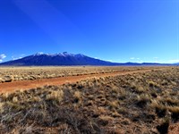
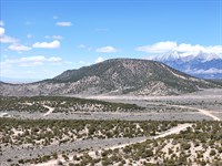
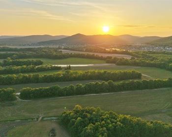
The Sangre de Cristo Ranches span more than 44,000 acres across the eastern slope of the Sangre de Cristo Mountain range south and east of Fort Garland, developed by Forbes Inc. beginning in 1971. At 8,998 feet, this parcel sits well into the upper zone of the subdivision - the elevation band where the landscape transitions from pinyon-juniper scrub to taller pines, where the views open across the San Luis Valley floor to the San Juan Mountains on the western horizon, and where the genuine mountain character of the property becomes unmistakable.
The Sangre de Cristo Mountains are the southernmost subrange of the Rocky Mountains, running from southern Colorado into northern New Mexico. The range includes several 14,000-Foot peaks within accessible distance of the Ranches - Blanca Peak at 14,345 feet is the fourth-highest summit in Colorado and visible from the property area. Crestone Peak and Crestone Needle, two of Colorado's most challenging fourteener climbs, are located in the northern Sangre de Cristo Range. The visual presence of these peaks from a nearly 9,000-Foot vantage point creates a scale and drama that lower-elevation properties in the same county simply cannot offer.
At 8,998 feet, summer temperatures are genuinely comfortable - daytime highs typically in the high 60s to mid-70s during July and August, with cool evenings that require a layer after sunset. This is not the searing high-desert heat of lower elevations. It is mountain summer: clear air, afternoon thunderstorms that pass quickly, mornings cool enough to require coffee by a fire. For buyers relocating from hot-summer regions - Texas, Arizona, California, the southern tier generally - this climate represents a fundamental quality of life upgrade during the months when heat elsewhere becomes oppressive.
Winter at this elevation is substantive. Snow accumulation is higher than the valley floor, access requires weather-appropriate vehicles and planning, and extended winter stays demand a properly insulated and heated structure. Seasonal owners who use the property spring through fall and retreat in winter make up a significant portion of the Ranches ownership community. Full-time residents exist at this elevation and manage winter effectively with the infrastructure choices described in the utility section above.
The roads within the Sangre de Cristo Ranches are maintained by Costilla County up to approximately 9,000 feet - this parcel sits right at that elevation boundary. A high-clearance or four-wheel-drive vehicle is standard equipment for owners at this elevation, particularly during and after winter weather events.
---
Mountain Home Reservoir: Trout Fishing and Camping at Your Doorstep
Mountain Home Reservoir State Wildlife Area sits approximately 15 minutes from this parcel and serves as one of the most practical nearby recreation assets for a Sangre de Cristo Ranches property owner at this elevation. The 250-Acre reservoir, managed by Colorado Parks and Wildlife southeast of Fort Garland off Ice House Road, supports a fishery stocked annually with rainbow trout throughout summer and open to ice fishing for northern pike in winter.
The reservoir features two boat ramps, dispersed primitive camping areas accessible for vehicles towing trailers up to 21 feet, and shoreline fishing access. No designated campsite reservations are required - a valid Colorado hunting or fishing license or State Wildlife Area pass grants access to camping and recreation. The surrounding pinyon-juniper terrain provides wildlife viewing opportunities including mule deer, waterfowl, and raptors.
For a property owner at 8,998 feet, coming down to the reservoir for a morning of fishing and returning to the mountain in the afternoon is a recreational cadence that defines the lifestyle value of this location. You are not driving to a destination - you are using your neighborhood amenities.
---
Great Sand Dunes National Park and Preserve
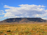
Great Sand Dunes National Park and Preserve is accessible from this parcel in approximately 39 minutes (35.8 miles). The park is one of the most visually arresting landscapes in Colorado - the tallest sand dunes in North America rising over 700 feet above the San Luis Valley floor, set against the backdrop of the Sangre de Cristo Mountains. The park holds International Dark Sky Park designation, recognizing the minimal light pollution and exceptional night sky quality of the San Luis Valley.
Activities include sand sledding and sandboarding year-round, open dunefield hiking without designated trails, backcountry dunefield camping with a free permit, 4WD exploration of Medano Pass Primitive Road, and seasonal Medano Creek wading when snowmelt peaks in late May and June. Ranger-led astronomy programs run May through September.
From 9,000 feet in the Sangre de Cristo Mountains, looking west across the San Luis Valley toward the dunes is its own experience - the valley spread out below you, the dune field visible in the middle distance as a pale irregularity against the valley floor. Being within 40 minutes of that park while sitting on your own mountain land is a position that very few property buyers in Colorado can occupy at this price point.
---
Zapata Falls: The Mountain Waterfall
Zapata Falls Recreation Area is approximately 43 minutes away (34.1 miles), on the western base of the Sangre de Cristo Mountains south of the park. The falls are accessed via a short trail through a narrow canyon slot, requiring a wade through a shallow stream channel before the waterfall opens dramatically inside the rock passage. Peak flows from snowmelt in June and July produce the most powerful cascade, though the falls are accessible through the fall season.
The elevated trailhead parking area provides panoramic San Luis Valley views that rival any overlook in southern Colorado. For mountain property owners who want a destination hike with genuine payoff, Zapata Falls delivers the kind of experience that justifies the drive - and from this property, it is less than an hour each way.
---
Fort Garland and Regional Services
Fort Garland sits approximately 14 minutes from this parcel at the intersection of Us-160 and Co-159. The town provides fuel (Conoco, Sinclair, Valero), the Red Rock General Store, basic supplies, a post office, and the Fort Garland Museum and Cultural Center - one of the best small-town history museums in Colorado, covering the frontier military history of the 1858 outpost and the multicultural heritage of the San Luis Valley.
Healthcare in the region is distributed across several facilities. The San Luis Health Center (Valley-Wide Health Systems) serves the southern county. Spanish Peaks Regional Health Center provides services through a La Veta clinic to the northeast. San Luis Valley Health Regional Medical Center in Alamosa offers the most comprehensive care in the region, approximately 36 minutes west. Colorado Springs, with full-spectrum specialty medical facilities, is approximately 2 hours 22 minutes northeast.
Schools serving the area include Sierra Grande High School and La Veta Public Schools nearby, and Alamosa High School approximately 36 minutes west.
Grocery access: Red Rock General Store for basics, Dollar General in Fort Garland for essentials, and Walmart Supercenter in Alamosa for full grocery and supply runs.
---
Wildlife, Hunting, and the Outdoor Ecosystem
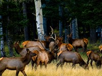
At 8,998 feet in Game Management Unit 83, this property sits at the upper end of the elk transition zone - the elevation where elk herds move seasonally between summer high-country grazing areas and lower winter range. The Sangre de Cristo Ranches area supports an estimated 7,000-Head elk herd in GMU 83, and over-the-counter bull licenses are available for the second and third rifle seasons, making this one of Colorado's more accessible elk hunting destinations without draw complexity.
The 6.25 acres of sloped mountain terrain, with native vegetation and natural cover, creates resident wildlife habitat that makes the property itself a daily wildlife viewing platform. Mule deer are abundant throughout the Ranches at this elevation. Wild turkeys are present in the mountain terrain. Pronghorn antelope inhabit the lower valley areas accessible from the property.
Community Greenbelt: The Sangre de Cristo Ranches maintains over 5,000 acres of community greenbelt designated for hunting and recreation by property owners. This community land reserve extends the effective hunting and outdoor recreation terrain well beyond individual parcel boundaries.
Raptors at elevation: Golden eagles hunt the mountain slopes and ridgelines throughout the Sangre de Cristo Range. Red-tailed hawks, Cooper's hawks, American kestrels, and northern harriers are regular presences above the mountain terrain. The diversity and density of raptors observable from a nearly 9,000-Foot parcel in the Sangre de Cristo Mountains exceeds what is possible from valley floor properties in the same county.
Dark Skies at 9,000 Feet: The International Dark Sky Park designation at Great Sand Dunes, 39 minutes west, gives a sense of the regional light pollution baseline - which is to say, nearly none. At 9,000 feet, above the atmospheric haze band that affects valley floor stargazing, the darkness and clarity of the night sky at this property represents some of the best amateur astronomy conditions in the continental United States. The Milky Way is not just visible - it is structural, arching across the full sky with the kind of detail and depth that makes astrophotographers drive hundreds of miles to find.
ATVs and Off-Road Recreation: The network of mountain roads threading through the upper Sangre de Cristo Ranches provides extensive ATV and UTV riding terrain. At 9,000 feet, the riding experience is genuinely alpine - mountain terrain, varied elevation, views across the San Luis Valley, and access to areas that are unreachable on foot within a reasonable day hike.
---
Investment Perspective: 6.25 Acres at the Top of the Sangre de Cristo Ranches
The 6.25-Acre parcel at 8,998 feet represents the largest acreage in this listing batch and the highest elevation - two factors that establish a distinct market position within the Sangre de Cristo Ranches inventory.
Larger parcels at higher elevations in the Ranches have historically commanded a per-acre premium over smaller, lower-elevation lots, reflecting both the scarcity of upper-elevation inventory and the qualitative difference in mountain character, views, and wildlife at elevation.
Annual carrying cost: $212.48 in property taxes - $17.71 per month. With no mandatory HOA, no special assessments, and a tax burden below $20 per month, the cost of holding this land while values develop and your plans take shape is among the lowest of any buildable mountain acreage in Colorado.
For the buyer who is not ready to build today but is ready to own: the off-grid path, the elevated terrain, the 6.25-Acre footprint, and the entry point of just $329 per month through owner financing represent an access point to Colorado mountain land ownership that the front range and resort county markets closed off years ago.
Exit strategies for future disposition include the broad owner-financed land market, direct sale to end users seeking off-grid mountain retreats, and appeal to the growing population of full-time remote workers who have permanently decoupled from urban geography and are now locating their primary residences based on lifestyle criteria rather than proximity to an office.
---
Why Remote Workers and Off-Grid Seekers Choose This Property
The remote work transition created a permanent cohort of professionals for whom geography is now a lifestyle choice, not an employment constraint. For that cohort, the question is not whether they can live at 9,000 feet in the Sangre de Cristo Mountains - it is whether they want to, and whether the infrastructure exists to support it.
The infrastructure answer is yes. Starlink satellite internet at 100-200 Mbps operates effectively at this elevation. A solar power system handles residential energy needs reliably in the high-solar-irradiance environment of the southern Rockies. Propane handles heating and cooking. Water from a well. Septic for waste. The full stack of off-grid infrastructure that once required significant technical sophistication is now routinely designed, installed, and operated by homeowners without specialized backgrounds.
The lifestyle answer is also yes - for the right buyer. Mornings at 9,000 feet in the Sangre de Cristo Mountains are a specific experience. Cool air, elevation silence broken only by wind and birds, the San Luis Valley visible below, the Sangre de Cristo peaks above. The work happens on a laptop with a satellite connection. The commute is to the door. The view from the home office is mountains.
No HOA means no restrictions on how the property is used for business, no rules about antennas or satellite dishes, no prohibitions on work vehicles, no architectural committee with opinions about your building's exterior. The county framework applies - Estate Residential zoning - and within that framework, you design your life without organizational interference.
---
Purchase Options - Own This Mountain for As Low As $329 Per Month
This parcel is offered at three entry points. All options convey ownership via recorded Warranty Deed after closing.
Cash Purchase
Sale Price: $19,999
Down Payment: $500
Documentation Fee: $249
Total Due Today: $749
Recording: Warranty Deed recorded after closing
Super Saver Financing - 3.5-Year Plan (Best Value)
Monthly Payment: $531.71/Month
Loan Term: 42 months
Down Payment: $499
Documentation Fee: $249
Total Due Today: $748
No credit check required
No prepayment penalty
Easy Financing - 6.5-Year Plan (As Low As $329/Month)
Monthly Payment: $329/Month
Loan Term: 78 months
Down Payment: $299
Documentation Fee: $249
Total Due Today: $548
No credit check required
No prepayment penalty
All financing is provided directly by the seller. No bank, no credit bureau, no approval process between you and your land. Own 6.25 acres of Sangre de Cristo mountain land for as low as $329 per month with just $548 due today.
---
100-Day No-Nonsense Guarantee
Purchase this property and change your mind within 100 days of your down payment - let us know. We will either refund your principal payment or exchange it for another property in our inventory that better suits your needs. This guarantee lets you secure the property confidently before visiting in person.
On owner financing, we refund principal paid, excluding fees (closing costs, documentation fees, note maintenance fees, and taxes). Any late or missed payments during the guarantee period will automatically void the guarantee.
---
Annual Ownership Cost Summary
Property taxes: $212.48 per year ($17.71/Month)
HOA fees: None identified
Special assessments: None
Mandatory improvements: None
Time limit to build: No (permits valid 12 months from issuance, standard county process)
---
Property Details at a Glance
Property ID: 1093
Apn: 70238140
Address: 4650 Yamaha Road, Fort Garland, CO 81133
County: Costilla, Colorado
Subdivision: Sangre de Cristo Ranches, Unit J2
Lot: Block 230, Lot 4650
Acreage: 6.25 acres
Dimensions: 437.30 ft x 780.25 ft x 436.62 ft x 467.78 ft
Terrain: Sloped Mountain Property
Elevation: Approximately 8,998 ft above sea level
Flood Zone: C - above the 500-Year floodplain
Wetlands: None
Road: Yamaha Road - dirt access road
Zoning: Estate Residential (Er)
Min. Dwelling: 600 sq ft | Max. Height: 35 ft
Setbacks: 20 ft front / 5 ft sides / 25 ft rear
HOA: None identified
Annual Taxes: $212.48
Back Taxes: None
Tax Liens: None
Electricity: None available in area - off-grid solar required
Water: Well required
Sewer: Septic required
Gas: Propane
Trash: Private hauler (G T Trash Services: )
Internet: Starlink satellite recommended
GPS Center: 37.48395, -105.2907
Cash Price: $19,999
Super Saver: $531.71/Mo - $499 down + $249 doc, $748 today
Easy Finance: $329/Mo - $299 down + $249 doc, $548 today (As Low As $329/Month)
---
Contact us today to secure this parcel. Nearly 9,000 feet. 6.25 acres. No HOA. No electric bill. No one telling you what to do with your mountain. At $329 per month with no credit check, this is the off-grid Colorado mountain land play that does not require a permit to dream about - only the decision to act.
Disclaimer: Information is deemed reliable but not guaranteed. Buyers are encouraged to conduct independent due diligence prior to purchase.
Land Maps & Attachments
Directions to Land
Directions To Property
APN 70238140 | 4650 Yamaha Road, Fort Garland, CO 81133
Sangre de Cristo Ranches, Unit J2, Block 230, Lot 4650
GPS Center: 37.48395, -105.2907
Primary Starting Point: Alamosa, Colorado
(Regional hub - full services, airport, hospital)
1. From Alamosa, head east on US-160 East approximately 31 miles.
2. Pass through Blanca and continue to Fort Garland.
3. At Fort Garland, turn right (south) onto CO-159 South.
4. Continue south on CO-159 into the Sangre de Cristo Ranches.
5. Follow the subdivision roads into the upper Ranches area to Yamaha Road.
6. Proceed on Yamaha Road to GPS: 37.48395, -105.2907.
Approximate travel time: ~36 minutes from Alamosa
Note: A high-clearance or 4WD vehicle is strongly recommended for upper Ranches roads. County maintenance of Ranches roads extends to approximately 9,000 ft elevation. This parcel sits near that boundary - weather-appropriate vehicles and preparation are advised, particularly in winter months.
---
Secondary Starting Point: Fort Garland, Colorado
(Nearest town - approx. 14 min / 9.8 miles - fuel at Conoco, Sinclair, Valero)
1. From Fort Garland at the intersection of US-160 and CO-159, head south on CO-159 South.
2. Continue south approximately 6-8 miles into the Sangre de Cristo Ranches.
3. Follow the subdivision road network toward the upper elevation area, bearing toward Yamaha Road.
4. Proceed on Yamaha Road to GPS: 37.48395, -105.2907.
Approximate travel time: ~14 minutes (9.8 miles)
---
Secondary Starting Point: Colorado Springs, Colorado
(Closest major city - approx. 2 hr 22 min / 149 miles)
1. From Colorado Springs, head south on I-25 South.
2. Take exit 52 toward Walsenburg / US-160 West.
3. Head west on US-160 through Walsenburg, La Veta, and over La Veta Pass.
4. Continue west on US-160 to Fort Garland (approximately 1 hr 45 min from Colorado Springs).
5. At Fort Garland, turn left (south) onto CO-159 South.
6. Continue south into the Sangre de Cristo Ranches.
7. Follow subdivision roads to Yamaha Road and proceed to GPS: 37.48395, -105.2907.
Approximate travel time: 2 hours 22 minutes (149 miles)
---
Secondary Starting Point: Pueblo, Colorado
1. From Pueblo, head south on I-25 South approximately 50 miles to Walsenburg.
2. Take exit 52 and head west on US-160 over La Veta Pass to Fort Garland.
3. At Fort Garland, turn south on CO-159 and continue into the Ranches.
4. Follow subdivision roads to Yamaha Road, GPS: 37.48395, -105.2907.
Approximate travel time: ~2 hours from Pueblo
---
NOTE: This parcel sits at approximately 8,998 feet elevation in the upper Sangre de Cristo Ranches. Road conditions at this elevation can vary significantly by season. High-clearance or 4WD vehicles are recommended year-round for upper Ranches roads. Winter access requires snow-capable vehicles and should be planned with current road conditions in mind.
More Land Details
More Land from Collin Pettet
 5.1 AC : $15K
- 1.7 AC : $20K
- 5.7 AC : $10K
- 5.6 AC : $8.5K
- 0.2 AC : $9K
- 0.2 AC : $9K
- 5.1 AC : $8.5K
- 1 AC : $8.5K
- 1.6 AC : $9K
- 0.2 AC : $9K
- 5.4 AC
- 1 AC : $8.5K