Sangre DE Cristo Mountain Retreat
Cacky Rd : Fort Garland, CO 81133
Costilla County, Colorado
Land Description
Land Description
Some people spend thirty years waiting for retirement to do what they actually want to do. You do not have to wait that long.
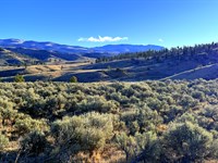
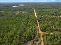
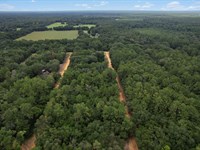
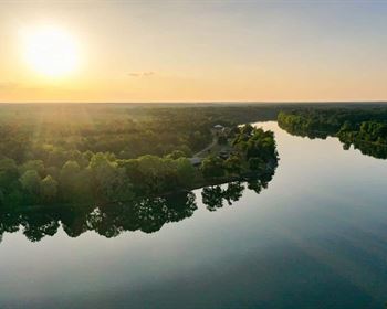
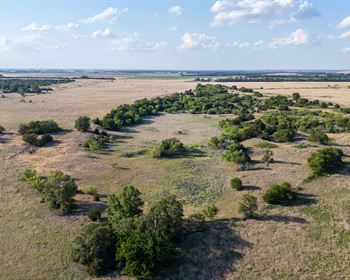
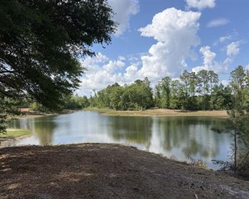
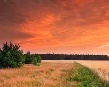
This 5.361-Acre parcel in Sangre de Cristo Ranches sits at 8,320 to 8,360 feet above sea level, tucked into the foothills of the Sangre de Cristo Mountains east of Fort Garland, Colorado. The terrain is gently sloping and lightly wooded - piñon pine, brush, native grasses, that unmistakable mountain character you cannot manufacture or import. It is the kind of land that makes you understand immediately why people have been trying to own a piece of southern Colorado for the better part of a century.
Mountain Home Reservoir State Wildlife Area - one of the best trout fisheries in southern Colorado, stocked annually and open to ice fishing in winter - is 13 minutes from this parcel. The Fort Garland Museum and Cultural Center is 13 minutes away. Great Sand Dunes National Park, with its International Dark Sky designation and the tallest dunes in North America, is 39 minutes west. Zapata Falls is 43 minutes southwest. You are not isolated here - you are positioned at the center of a region that outdoor-minded people travel hundreds of miles to reach, and you would own five acres inside it.
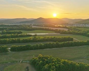
The subdivision - Sangre de Cristo Ranches - spans more than 44,000 acres rising from the San Luis Valley floor into the Sangre de Cristo Mountain range. At 8,320 feet, this parcel sits in the piñon-juniper zone, offering natural privacy screening that flat valley floor lots cannot provide. The gentle slope (50% flat / 50% slope, per survey) gives the parcel topographic interest while remaining buildable. The irregular lot dimensions - 260 ft north, 550 ft east, 595 ft south, 760 ft west - create a shape that naturally maximizes usable terrain across the 5.361-Acre footprint.
Access is via Cacky Road, a county-maintained dirt road. No HOA governs this property - a voluntary community association exists for those who want to participate, with an optional $25 annual fee, but membership is your choice. No approval process. No mandatory dues. No committee sign-off on your plans.
The county allows camping for up to 14 days every three months without septic in place, meaning you can begin enjoying the land immediately. The county also permits RV use on the same basis. Build when you are ready - or simply own a piece of the Sangre de Cristo Mountains and let the land work as a quiet store of value until the timing is right.
Owner financing is available with no credit check required. You can own this land for $265 down.
---
Property Specifications
- Parcel Number (Apn): 70216480
- Account Number: R011988
- Subdivision: Sangre de Cristo Ranches (S.D.C.R.), Unit E, Block 77, Lot 1004
- Legal Description: S.D.C.R. Unit E Blk 77 Lot 1004 Cont. 5.361 Ac
- Property Address: Cacky Rd, Fort Garland, CO 81133
- County: Costilla County, Colorado
- Acreage: 5.361 acres
- Lot Dimensions: 260 ft N / 550 ft E / 595 ft S / 760 ft W
- Shape: Rectangle
- Terrain: Gentle Slope, Lightly Wooded, Brush
- Slope: 50% Flat / 50% Slope
- Elevation: 8,320 - 8,360 feet above sea level
- GPS Coordinates (Center): 37.34990, -105.36655
- GPS Corners: NE 37.3505, -105.3661 | SE 37.3490, -105.3658 | SW 37.3486, -105.3676 | NW 37.3506, -105.3669
- Road Access: Cacky Rd (dirt, county-maintained)
- Flood Zone: Zone C - above the 500-Year floodplain (no flood insurance required)
- Wetlands: None present
- HOA: Voluntary only - Sangre de Cristo Ranches Community Association (optional $25/Year)
- Annual Property Taxes: $270.92
- Back Taxes: None
- Tax Liens: None
- Zoning: Estate Residential (Er)
- School District: Sierra Grande School District R-30
---
Zoning and Permitted Uses
This parcel carries Estate Residential (Er) zoning under Costilla County - a genuinely flexible rural residential designation with real latitude for how you use your land.
Single Family Dwelling: A permanent site-built home is permitted. The minimum dwelling size is 600 square feet per county code; the Sangre de Cristo Ranches Cc&Rs specify a minimum of 600 square feet for single-story construction and 800 square feet for two-story construction. Building permits are valid for one year from issuance and may be extended with county approval.
Manufactured and Mobile Homes: Manufactured homes are permitted, provided they meet placement requirements and utility access standards. Homes must be manufactured after 1976. This opens a practical, cost-effective path to establishing a permanent presence on the property without the timeline and expense of stick-built construction.
Tiny Homes: County regulations permit structures at or above 600 square feet that meet code and placement requirements. This creates a pathway for compact, efficient building designs that are increasingly popular among off-grid and mountain lifestyle buyers.
Camping: You may camp on the property for up to 14 days every three months without a septic system. This means the land is immediately usable - you do not need to wait for infrastructure installation before your first weekend on your own property.
RV Parking and Use: RVs are permitted for the same 14-day window every three months without septic in place. Once a septic system is installed, extended occupancy becomes practical.
Short-Term Rentals: Short-term vacation rentals are allowed per county regulations, subject to Colorado state guidelines. Mountain properties in this location have proven appeal to visitors using Great Sand Dunes National Park and the broader San Luis Valley as a destination.
No Mandatory HOA: The Sangre de Cristo Ranches Community Association is voluntary, with an optional annual fee of $25. Membership is entirely at your discretion. There is no requirement to join, pay dues, or comply with HOA governance. Your land use is governed by Costilla County's zoning framework - period.
Building permits and planning questions: Costilla County Planning and Zoning at.
---
Utility Infrastructure
Water: A well or alternative water solution is required for permanent residential use. The Sangre de Cristo Ranches area has an established history of residential well drilling, with depths varying by parcel location and elevation. Contact the Colorado Division of Water Resources for well permit information and a licensed Colorado well driller for site-specific depth estimates. Alternative approaches include cistern systems with water haul service for seasonal or transitional use.
Sewer/Septic: A septic system with leach field is required for full-time or permanent use. Permit requirements through the Costilla County Health Officer in San Luis. Many buyers install a basic tank-and-field system as the first utility step toward buildable status and legal extended camping.
Electric: No power poles are visible near this property per the due diligence report. Off-grid solar power is the primary practical pathway for this parcel. At 8,320 feet elevation in the southern Rocky Mountains, this property receives exceptional solar exposure - the San Luis Valley and surrounding foothills consistently rank among the highest solar energy production zones in Colorado. A well-designed off-grid solar system with battery storage and a propane backup generator can power a full residential setup reliably year-round. To explore grid power extension possibilities, contact Xcel Energy at , though the distance and terrain may make off-grid the more practical and cost-effective choice.
Propane: For heating and cooking, contact La Veta Propane Inc at. Many full-time Sangre de Cristo Ranches residents use wood stoves as a primary heating source, supplemented by propane. The subdivision has historically offered access to a "Wood Fest" event where residents can obtain firewood from private forests on the property at minimal cost.
Waste Removal: Private hauler service available through G T Trash Services at.
Internet and Communications: Starlink satellite internet delivers 100-200 Mbps download speeds at this elevation and location. The Sangre de Cristo Ranches' elevation and clear sky access make Starlink dish installation straightforward and reliable. Jade Wireless/Blanca Telephone also provides service to portions of the ranches. Full-time remote workers operating from this property have a functional, high-speed internet solution available from day one.
Cell Service: Coverage varies by carrier across the Ranches. Satellite communication remains the most consistent backup for remote mountain properties.
---
The Sangre de Cristo Ranches: Colorado's Mountain Subdivision
The Sangre de Cristo Ranches is one of the largest and most distinctive rural subdivisions in Colorado - a 44,000-Plus acre community spread across the eastern slope of the Sangre de Cristo Mountains east and south of Fort Garland. Originally developed by Forbes Inc. beginning in 1971, the Ranches drew buyers from across the country seeking affordable access to Colorado mountain land with the infrastructure of a planned subdivision - surveyed lots, county-maintained roads, legal access - combined with the freedom of genuine rural mountain living.
This parcel, at 8,320 to 8,360 feet elevation, occupies the piñon-juniper vegetative zone that characterizes the mid-elevation Ranches. Piñon pine and juniper provide natural privacy screening, visual interest across seasons, and a wildlife habitat matrix that supports a resident population of mule deer, elk, pronghorn, and diverse raptors. The light woodland cover creates shade for summer camping and gives the parcel a mountain character that flat valley floor properties simply cannot replicate.
The subdivision contains a mix of permanent full-time residents, seasonal owners, and long-term land holders who have owned their parcels for decades and use them for camping, hunting, and eventual retirement. There is no crowding problem in Sangre de Cristo Ranches - the 44,000 acres of the larger subdivision plus over 5,000 acres of dedicated community greenbelt provide the density levels of genuine mountain land rather than suburban subdivision. Your neighbors are few, your views are wide, and the wildlife has no intention of leaving.
Roads within the Ranches are maintained by Costilla County up to approximately 9,000 feet elevation, providing year-round access under normal conditions. Cacky Road, which serves this parcel, is a county-maintained dirt road accessible by standard vehicles in dry and moderate weather conditions. High-clearance or four-wheel-drive vehicles provide an advantage during winter months and wet conditions.
The community association website at provides supplemental information on the voluntary association, area events including Wood Fest, and community resources for property owners. Participation is entirely optional.
---
Mountain Home Reservoir: Your Local Fishing Destination
Mountain Home Reservoir State Wildlife Area sits just 13 minutes (7.0 miles) from this parcel and represents one of the most accessible quality fishing destinations in southern Colorado for a property owner in this location. The 250-Acre reservoir, located southeast of Fort Garland off Ice House Road, is managed by Colorado Parks and Wildlife as a State Wildlife Area.
Fishing: The reservoir is stocked throughout the summer months with rainbow trout by Colorado Parks and Wildlife, creating reliable angling conditions during the warm season. Northern pike are present year-round and become a primary target during winter ice fishing when trout activity slows. The fishery has logged over 460 documented condition reports, reflecting a deep community of regular anglers who return year after year. Shore fishing is accessible along the reservoir edges near the dam and boat ramp areas; a public boat launch allows for trolling or casting from vessels.
Ice Fishing: The reservoir opens to ice fishing in winter, extending the angling season through the coldest months. Northern pike and trout provide winter fishing action that attracts anglers who prefer the solitude of off-season visits.
Camping: Dispersed primitive camping is available around the reservoir shoreline for visitors with a valid Colorado hunting or fishing license or State Wildlife Area pass. Multiple pull-off areas can accommodate tents and trailers up to 21 feet. The access road is well-maintained and passable under normal conditions.
Boating: Four public boat launches serve the reservoir. Motorized vessels are permitted with restrictions on wake-creating operation, making the reservoir practical for trolling, kayaking, canoe fishing, and small craft use.
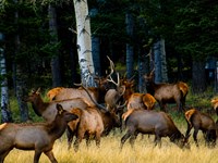
Wildlife: The pinyon-juniper hills surrounding the reservoir support waterfowl, loons, diverse shorebirds, and forest species including pinyon jay. Elk and mule deer are regularly observed in the area. The backdrop of mountain terrain rising from the water creates exceptional wildlife viewing conditions.
For a property owner living 13 minutes away, Mountain Home Reservoir is a practical extension of your outdoor living space - accessible for an early-morning fishing session, an afternoon on the water, or a winter ice fishing excursion without the logistical commitment of a destination trip.
---
Fort Garland: Gateway to the San Luis Valley
Fort Garland, Colorado, sits just 14 minutes east of this parcel at the historic intersection of Us-160 and Co-159. This small but strategically positioned community earns its designation as "The Gateway to the San Luis Valley" - it stands at the transition point between the mountain terrain of the Sangre de Cristo foothills and the open expanse of the valley floor.
Services in Fort Garland include a Conoco gas station at 700 4th Ave (14 minutes, 9.5 miles), basic supplies, dining options, a post office, and the Fort Garland Museum and Cultural Center. The museum preserves the history of the 1858 U.S. Army outpost that gave the town its name, commanded briefly by the legendary frontiersman Kit Carson from 1866 to 1867. The exhibits cover the Buffalo Soldiers stationed at the fort, the multicultural history of the San Luis Valley, and the frontier military experience in a genuinely well-curated small-town museum.
Alamosa, the San Luis Valley's full-service hub, is approximately 36 minutes west. Adams State University, SLV Health Regional Medical Center, Walmart Supercenter, Home Depot, diverse dining, and regional airport services are all accessible within a reasonable drive. The Rio Grande Scenic Railroad offers seasonal passenger service from Alamosa through the valley, adding a recreation and tourism dimension to the regional economy.
La Veta, a scenic mountain arts community in Huerfano County, sits approximately 41 minutes northeast over La Veta Pass. Colorado Springs, the closest major metro area, is 2 hours 22 minutes northeast via Us-160 and I-25.
---
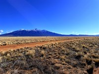
Great Sand Dunes National Park and Preserve
Great Sand Dunes National Park and Preserve lies 39 minutes (35.8 miles) west of this parcel - a meaningful but manageable distance that keeps the park accessible for regular visits without positioning you in the higher-traffic corridor immediately adjacent to the park entrance.
The dunes are the tallest in North America, rising over 700 feet above the valley floor across more than 19,000 acres. The park carries International Dark Sky Park designation - a status earned by documented light pollution levels that place the dunefield among the darkest accessible night sky environments in the continental United States. Special astronomy programming runs May through September, and the park is open 24 hours a day, 365 days a year.
Activities include sand sledding and sandboarding year-round, hiking across the open dunefield (no designated trails - you choose your own path), backcountry dunefield camping with a free permit, 4WD exploration of Medano Pass Primitive Road, and Medano Creek wading when seasonal flows peak in late May and June. The park visitor center at 8,170 feet elevation provides orientation, exhibits, and ranger-led programs.
Owning land in Sangre de Cristo Ranches and making the 39-minute drive to Great Sand Dunes represents a fundamentally different relationship with the park than visiting as a tourist - you are a regional neighbor using a local landmark, not a destination traveler fighting for a parking spot.
---
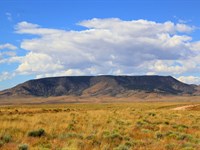
Zapata Falls Recreation Area
Zapata Falls sits 43 minutes southwest (34.1 miles), accessible via a short trail from a trailhead parking area on the western base of the Sangre de Cristo Mountains. The falls are hidden inside a narrow canyon slot requiring a wade through a shallow stream passage before opening onto the falls themselves - a waterfall experience that rewards the effort with a scale and drama that roadside viewpoints cannot match.
The elevated trailhead parking provides panoramic San Luis Valley views that rival any designated overlook in southern Colorado. The falls hike is accessible from spring through fall, with peak flows during snowmelt runoff in June and July.
---
Mother Mary's Garden and the Stations of the Cross
At 25 minutes southwest (21.5 miles), the Stations of the Cross sculpture garden outside San Luis represents one of the most distinctive cultural landmarks in southern Colorado. San Luis is Colorado's oldest continuously occupied town, founded in 1851. The outdoor sculpture garden featuring fourteen large bronze Stations of the Cross figures on the hillside above town draws visitors of all backgrounds who appreciate the scale, craftsmanship, and setting of one of the American Southwest's most unusual public art installations.
The broader San Luis area reflects the Spanish colonial and Hispanic cultural heritage that has shaped Costilla County for four centuries - a depth of history that generic rural counties simply do not have.
---
Wildlife, Hunting, and Outdoor Recreation
The Sangre de Cristo Ranches and surrounding Costilla County public lands provide exceptional hunting, wildlife viewing, and outdoor recreation in a GMU 83 designation that carries significant elk population density.
Elk: The Sangre de Cristo Ranches area supports an estimated 7,000-Head elk herd across Game Management Unit 83. Bull elk licenses for the second and third rifle seasons are available over the counter (Otc) for GMU 83, making this an accessible elk hunting destination without the draw complexity that restricts hunting in many Colorado units. The piñon-juniper terrain at this elevation provides transitional habitat that elk use actively during morning and evening movement periods.
Mule Deer: Mule deer are abundant throughout the Ranches at this elevation, using the brush and wooded cover for bedding and moving to open areas for feeding. The lightly wooded terrain of this specific parcel - 50% slope, piñon brush, native vegetation - is characteristic mule deer habitat.
Pronghorn Antelope: The open rangeland below the Ranches and across the San Luis Valley floor supports strong pronghorn populations visible during morning and evening hours along the access roads and county highways.
Community Greenbelt: Sangre de Cristo Ranches maintains over 5,000 acres of designated greenbelt available to property owners for hunting and recreation. This community land reserve provides access to expanded hunting and outdoor recreation terrain beyond individual parcel boundaries - a meaningful amenity not found in typical rural land subdivisions.
Raptors and Eagles: The mountain terrain at this elevation provides exceptional raptor habitat. Red-tailed hawks, Cooper's hawks, American kestrels, golden eagles, and northern harriers are regularly observed hunting the brushy slopes and open areas of the Ranches. The Costilla County area has documented Ferruginous hawk presence - the largest hawk native to North America.
ATVing and Off-Road Recreation: The network of county-maintained and private roads through the Sangre de Cristo Ranches provides extensive off-road exploration opportunities for ATV and UTV owners. The varied terrain - from valley floor access roads to mountain tracks threading through the piñon forest - offers riding environments that flat land properties cannot match.
Dark Skies: At 8,320 feet elevation and well above the light scatter of any population center, this property offers stargazing quality consistent with the broader San Luis Valley's Bortle Class 2-3 dark sky designation. The Milky Way is visible with the naked eye on any clear night. The combination of elevation, mountain air clarity, and minimal light pollution creates astronomy conditions that attract astrophotographers and casual stargazers alike.
---
Costilla County: Value, History, and Low Carrying Costs
Costilla County spans approximately 1,227 square miles with a population of roughly 3,500 residents - fewer than three people per square mile. The county's history runs deep: San Luis, the county seat, is Colorado's oldest continuously occupied town. The Hispanic colonial heritage dating back to the 1840S land grants, combined with the frontier military history centered on Fort Garland, gives this region a cultural layering that newer Colorado communities cannot replicate.
Annual taxes on this 5.361-Acre parcel are $270.92 - approximately $22.58 per month. The assessed actual value is $12,750, reflecting the county's genuine rural land values rather than the inflated assessments of front-range or resort counties. No HOA dues are mandatory. No special district fees are assessed. The carrying cost of owning this property free and clear is $22.58 per month in property taxes.
County services include maintained roads, planning and zoning administration at , and a full county government structure with assessor at , treasurer at , and recorder at. The county website is Perspective: Sangre de Cristo Ranches Land Ownership
The Sangre de Cristo Ranches subdivision has attracted land buyers for more than fifty years, beginning with the Forbes Inc. development in 1971 and continuing through successive waves of buyers seeking affordable Colorado mountain land. That sustained buyer demand across multiple economic cycles reflects something real about the appeal of this specific location: mountain terrain, wildlife, access to recreation, and established subdivision infrastructure at a price point that has consistently remained accessible to buyers who would be priced out of resort-adjacent Colorado markets.
At 8,320 feet in a lightly wooded piñon-juniper setting, this parcel offers a qualitatively different experience than flat valley floor lots - natural screening, topographic interest, wildlife habitat, and mountain character that commands a genuine premium in the rural Colorado land market. The $270.92 annual tax burden ensures that the cost of holding this land while values develop is manageable for any buyer with long-term ownership intentions.
Land investors who hold Sangre de Cristo Ranches parcels benefit from the same dynamic that has driven the broader Colorado rural land market: sustained demand from an expanding pool of buyers seeking affordable rural retreats, off-grid lifestyle options, and retirement land that the front range and resort markets have priced out of reach. The combination of low carrying costs, no mandatory HOA, established subdivision infrastructure, and proximity to national park and state wildlife area assets creates a durable value foundation that pure raw land elsewhere lacks.
Exit options for future sellers include the broad owner-financed land market (where low-down-payment buyers have consistently demonstrated demand for Costilla County parcels), direct sale to end users building retirement or recreational retreats, and eventual subdivision potential for larger holdings.
---
Why This Property for the Retiree and Pre-Retiree
The Sangre de Cristo Ranches has attracted retirement-minded buyers for decades - and for straightforward reasons. At 8,320 feet, the summer climate is mild, with daytime highs typically in the low-to-mid 70s and cool evenings that make outdoor living comfortable without air conditioning. The winter is real - this is the mountains - but the elevation is moderate enough that year-round access and extended seasonal use are practical for most buyers.
Healthcare is accessible without excessive distance. Alamosa, 36 minutes west, provides SLV Health Regional Medical Center for primary care and emergency services. Colorado Springs, with a full range of specialty medical facilities, is 2 hours 22 minutes northeast. The Fort Garland community provides a small-town social environment for full-time residents seeking a quieter pace with genuine mountain character.
The layout of this particular parcel - gently sloping, lightly wooded, with a buildable footprint across the 5.361 acres - accommodates the range of retirement lifestyle visions: a permanent single-family home set back among the piñon trees, a manufactured home on the most level portion of the lot, or a simple seasonal retreat structure used during the spring-through-fall window while maintaining a primary residence elsewhere.
No HOA means no approval process for your plans. No mandatory association participation. No restrictions beyond the county's sensible zoning framework. Build when you are ready, at whatever scale matches your life and budget at that point.
For the pre-retiree who is five or ten years from transition: purchase now, camp and explore the land on weekends and vacation visits, and let the property appreciate and familiarize itself to you before you decide how to develop it. The annual holding cost - $270.92 in property taxes - is less than most people spend on a single restaurant dinner per month.
---
Purchase Options
This parcel is offered at three entry points. All options convey ownership via recorded Warranty Deed after closing.
Cash Purchase
Sale Price: $14,999
Down Payment: $500
Documentation Fee: $249
Total Due Today: $749
Recording: Warranty Deed recorded after closing
Super Saver Financing - 3.3-Year Plan (Best Value)
Monthly Payment: $459.58/Month
Loan Term: 30 months
Down Payment: $425
Documentation Fee: $249
Total Due Today: $674
No credit check required
No prepayment penalty
Easy Financing - 6-Year Plan
Monthly Payment: $300/Month
Loan Term: 72 months
Down Payment: $265
Documentation Fee: $249
Total Due Today: $514
No credit check required
No prepayment penalty
All financing is provided directly by the seller. No bank, no credit bureau, no approval process.
---
100-Day No-Nonsense Guarantee
Purchase this property and change your mind within 100 days of your down payment - let us know. We will either refund your principal payment or exchange it for another property in our inventory that better suits your needs. This guarantee lets you secure the property confidently before visiting in person.
On owner financing, we refund principal paid, excluding fees (closing costs, documentation fees, note maintenance fees, and taxes). Any late or missed payments during the guarantee period will automatically void the guarantee.
---
Annual Ownership Cost Summary
Property taxes: $270.92 per year ($22.58/Month)
HOA fees: $0 mandatory ($25/Year voluntary - your choice)
Special assessments: None
Mandatory improvements: None
Time limit to build: No (permits valid 1 year from issuance, renewable)
---
Property Details at a Glance
Property ID: 1092
Apn: 70216480
Address: Cacky Rd, Fort Garland, CO 81133
County: Costilla, Colorado
Subdivision: Sangre de Cristo Ranches (S.D.C.R.), Unit E
Lot: Block 77, Lot 1004
Acreage: 5.361 acres
Dimensions: 260 ft N / 550 ft E / 595 ft S / 760 ft W
Shape: Rectangle
Terrain: Gentle Slope, Lightly Wooded, Brush
Slope: 50% Flat / 50% Slope
Elevation: 8,320 - 8,360 ft above sea level
Flood Zone: C - above the 500-Year floodplain
Wetlands: None
Road: Cacky Rd - dirt, county-maintained
Zoning: Estate Residential (Er)
HOA: Voluntary only ($25/Yr optional)
Annual Taxes: $270.92
Back Taxes: None
Tax Liens: None
Power: No visible poles nearby - off-grid solar recommended (Xcel Energy: )
Water: Well required
Sewer: Septic required
Propane: La Veta Propane Inc )
Internet: Starlink satellite recommended
GPS Center: 37.34990, -105.36655
Cash Price: $14,999
Super Saver: $459.58/Mo - $425 down + $249 doc $674 today
Easy Finance: $300/Mo - $265 down + $249 doc $514 today
---
Contact us today to reserve this parcel. Five acres in the Sangre de Cristo Mountains with Mountain Home Reservoir at your doorstep and Great Sand Dunes on your horizon - at $265 down with no credit check. That combination does not stay on the market long.
Disclaimer: Information is deemed reliable but not guaranteed. Buyers are encouraged to conduct independent due diligence prior to purchase.
Land Maps & Attachments
Directions to Land
Directions To Property
APN 70216480 | Cacky Rd, Fort Garland, CO 81133
Sangre de Cristo Ranches, Unit E, Block 77, Lot 1004
GPS Center: 37.34990, -105.36655
Primary Starting Point: Alamosa, Colorado
(Regional hub - full services, airport, hospital)
1. From Alamosa, head east on US-160 East.
2. Continue approximately 31 miles east through the San Luis Valley, through Blanca, toward Fort Garland.
3. In Fort Garland, turn right (south) onto CO-159 South.
4. Continue south on CO-159 approximately 6 miles into the Sangre de Cristo Ranches area.
5. Turn onto Cacky Rd and proceed to GPS: 37.34990, -105.36655.
Approximate travel time: 36 minutes (approx. 31 miles from Alamosa)
---
Secondary Starting Point: Fort Garland, Colorado
(Nearest town - 14 min / 9.8 miles - fuel and services available)
1. From Fort Garland at the intersection of US-160 and CO-159, head south on CO-159 South.
2. Continue south approximately 6 miles into the Sangre de Cristo Ranches.
3. Turn onto Cacky Rd and proceed to GPS: 37.34990, -105.36655.
Approximate travel time: 14 minutes (9.8 miles)
---
Secondary Starting Point: Colorado Springs, Colorado
(Closest major city - 2 hr 22 min / 149 miles)
1. From Colorado Springs, head south on I-25 South.
2. Take exit 52 toward Walsenburg / US-160 West.
3. Head west on US-160 through Walsenburg and La Veta, over La Veta Pass.
4. Continue west on US-160 to Fort Garland (approximately 1 hr 45 min from Colorado Springs).
5. In Fort Garland, turn left (south) onto CO-159 South.
6. Continue south approximately 6 miles into the Sangre de Cristo Ranches.
7. Turn onto Cacky Rd and proceed to GPS: 37.34990, -105.36655.
Approximate travel time: 2 hours 22 minutes (149 miles)
---
Secondary Starting Point: Pueblo, Colorado
(via I-25 South / US-160 West)
1. From Pueblo, head south on I-25 South approximately 50 miles to Walsenburg.
2. Take exit 52 and head west on US-160 through La Veta and over La Veta Pass.
3. Continue west to Fort Garland, then south on CO-159 into the Ranches.
4. Turn onto Cacky Rd and proceed to GPS: 37.34990, -105.36655.
Approximate travel time: Approximately 2 hours from Pueblo.
---
NOTE: Cacky Rd is a county-maintained dirt road. Standard vehicles are typically adequate in dry conditions. High-clearance or four-wheel-drive vehicles are recommended during winter or wet conditions. Roads within the Sangre de Cristo Ranches are maintained by Costilla County up to approximately 9,000 feet elevation.
More Land Details
More Land from Collin Pettet
 5.1 AC : $15K
- 1.7 AC : $20K
- 5.7 AC : $10K
- 5.6 AC : $8.5K
- 0.2 AC : $9K
- 0.2 AC : $9K
- 5.1 AC : $8.5K
- 1 AC : $8.5K
- 1.6 AC : $9K
- 0.2 AC : $9K
- 1 AC : $8.5K
- 4.9 AC : $7.5K