Hillside Property Near Oroville WA
Round Up Rd Lots 12 And 13 : Oroville, WA 98844
Okanogan County, Washington
Land Description
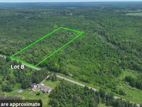
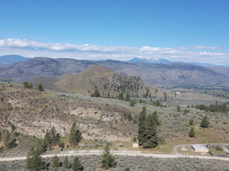
Mountain and Valley Views: 21-Acre Hillside Property Near Oroville Wa
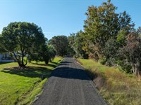
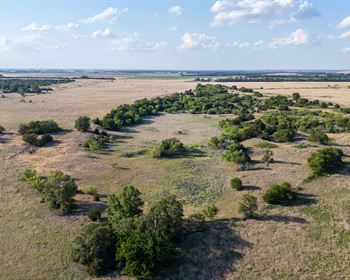
Two adjoining hillside parcels on Round Up Rd outside Oroville, rising from the road toward the ridgeline with open native vegetation, dry mountain air, and mountain and valley views from elevated terrain. Buy one parcel or combine both for a full 21.17± acre hillside footprint with maximum privacy and flexibility in how the property comes together.
Property at a glance
Mountain and valley view potential from elevated terrain
Overhead power at street via Okanogan Pud
R5 zoning | single-family residential permitted
Manufactured homes permitted with county requirements
No known barriers to residential well drilling per county
Outside city limits | rural Okanogan County
Buy one parcel or both | flexible purchase options
Owner financing available on flexible terms
Septic suitable | site evaluation confirmed by Okanogan County
Well installation required
Dirt road access via Round Up Rd
Sloped terrain | will factor into site planning and access
RV and camping use | confirm specifics with county
Manufactured homes require tongue removal, permanent steps, exterior seal, and permitting
Overhead power is available at the street through Okanogan Pud. A well will need to be drilled for water; the county has indicated no known barriers to a residential well on this property. Septic installation will be required, with system type and size determined at the time of permit application through Okanogan County. No natural gas is available in the area; propane is typical for rural properties in Okanogan County.
All Property Details
County: Okanogan County, Washington
Street: 0 Round Up Rd Lots 12 and 13 Oroville, WA 98844
Parcel number: /
Size: 21.17 acres total / 10.82 and 10.35 acre tracts
Terrain: Open, rising, and naturally cleared, the terrain moves confidently from the road toward the ridgeline with native grasses and sagebrush filling in a landscape that feels genuinely untouched. The slope is the big point here, putting future homesites in position to look out over the valley rather than being stuck at the bottom of it
Access: Rural maintained dirt road - Round Up Rd
Property zoning: (R5) - Rural 5
Rv's: Not allowed for residency
Mobile / Manufactured Homes: Allowed
Camping: Allowed
Minimum Build Size / How Many Homes Can I Build?: No minimum build size. Per R5 zoning, one home per 5 acres, plus accessory outbuildings if desired
Short term rentals: Allowed
Covenants / POA / HOA: None, formerly existed but was dissolved 1993
Taxes: ~$212.86 and ~$216.22 annually (2025)
Electric: Overhead lines at street
Okanogan Pud:
Water: Will need to install a well
Sewer: Will need to install a septic system. Site evaluation completed and confirmed suitable by Okanogan County Public Health District; system type and size determined at time of permit application
Utilities disclaimer: We do not make recommendations on any vendors. The utilities installer contacts listed are purely for your information. There may be other options available in the area. Please use this information at your own discretion.
“Refer someone who buys land from us and we will pay a referral fee..”
As a nationwide real estate investment firm specializing in land acquisition and sales, we empower our clients to make informed decisions. Although we don't conduct on-site meetings, we strongly recommend you visit the property to experience its potential firsthand. Ready to explore? Contact us today to arrange your site visit.
Disclaimer: We make every effort to provide accurate and up-to-date information about this property based on available public sources and our own research. However, it is the buyer's responsibility to verify all information, including but not limited to: zoning, access, utilities, buildability, and permitted uses. All buyers are encouraged to conduct their own due diligence before purchasing. This property is sold “as-is” with no warranties or guarantees, expressed or implied.
Land Maps & Attachments
Directions to Land
Starting in central Oroville, WA 98844 at the intersection of Apple Way Ave and US-97 S/Main St, head southwest on US-97 S/Main St toward Hwy 7. Continue to follow US-97 S for 6.1 miles, then turn left onto O'Neil Rd for 0.7 miles. Turn left onto Swanson Mill Rd for 2.7 miles, then turn right onto Round Up Rd for 0.3 miles to reach your destination at the 21.17-acre property in two lots on Round Up Rd in Oroville, WA 98844.
Total distance: 9.8 miles, approximately 15 minutes.
More Land Details
More Land from Scott Taylor
 2 AC : $70K
- 0.4 AC : $23K
- 1.6 AC : $20K
- 4.9 AC : $20K
- 9.1 AC : $32.8K
- 5 AC : $22.5K
- 3.8 AC : $37K
- 2.1 AC : $60K
- New1.3 AC : $29K
- 1 AC : $19K
- 5.1 AC : $19K
- 2.8 AC : $18K