Oregon Pines, 1.6 Acre, $188 Down
Pines Lot 8 : Dairy, OR 97625
Klamath County, Oregon
Land Description
You have been waiting for the right moment. The right property. The right price. Something real - a piece of actual land with your name on the deed - that does not require a bank loan, a perfect credit score, or years of saving before you can make a move. This is that property.
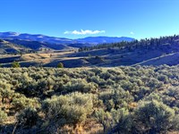
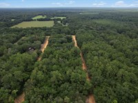
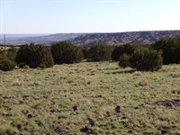
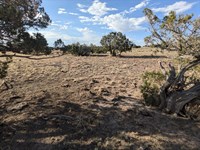
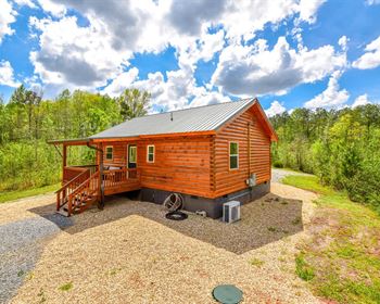
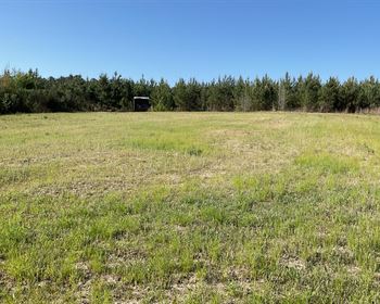
Welcome to 1.64 acres in the Oregon Pines subdivision of Klamath County, Oregon - flat, open high-desert terrain at 4,900 feet above sea level, positioned directly between the Fremont National Forest and the Winema National Forest, with the Fremont-Winema National Forest boundary sitting less than 1 mile northwest of the property line. Annual property taxes run $49. No HOA. No mandatory dues. No time limit to build. Owner financing starts at $188 down with no credit check and no bank required.
This is Lot 8, Block 8 of Oregon Pines - a legally accessible parcel reached via county-maintained dirt road, sitting in one of the most recreationally rich corners of southern Oregon. Klamath County is the home of Crater Lake National Park, the deepest lake in the United States and one of the most visually extraordinary landscapes on the planet - approximately 1.5 hours from your front door. The Sprague River runs through the Beatty community 20 minutes away, offering rainbow trout, brown trout, and bass fishing in uncrowded, productive water. The Williamson River - one of the Pacific Northwest's premier trophy trout destinations, where native redband rainbows routinely reach 10 to 20 pounds - is approximately 45 minutes west. Oregon's longest linear state park, the 100-Mile Oc&E Trail, begins in the town of Dairy just 10 to 15 minutes from the property.
You do not need to borrow from a bank. You do not need to wait for your credit score to improve. You need $188 and the decision to start. Your Oregon land is waiting.
Your Path To Ownership Starts At $188
Most people who want to own land believe they cannot. They think land ownership requires a mortgage, a bank approval, a large down payment, or a credit score that disqualifies them before they even ask. None of that applies here.
This property is available with three ownership paths. The lowest monthly payment is $205 per month - less than many cell phone bills. The lowest entry point is $438 total due today. No credit check. No bank. No appraisal. No underwriting timeline. The paperwork is simple, the process is fast, and the deed is recorded in your name.
For first-time land buyers, this is one of the most direct paths to ownership available in Oregon. The land is real. The taxes are $49 per year. The road access is legal. The recreational landscape surrounding the property is exceptional. What changes when you own it is the answer you give when someone asks: "Do you own any land?" The answer becomes yes.
Property Highlights At A Glance
Parcel: Lot 8, Block 8 - Oregon Pines Subdivision
Apn: R276597
Address: Oregon Pines Lot 8, Dairy, OR 97625
County: Klamath County, Oregon
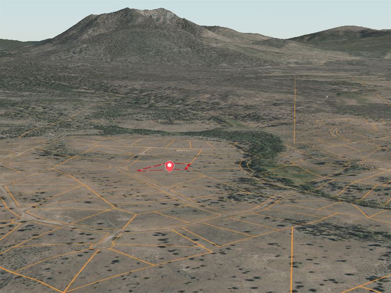
GPS Center: 42.54391, -121.41170
Parcel Size: 1.64 acres (1.646 acres calculated)
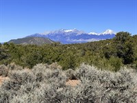
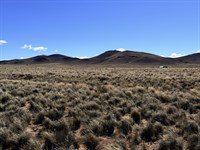
Terrain: Flat/Level - open rural high-desert, lightly wooded
Elevation: 4,900 ft above sea level
Shape: Polygon
Flood Zone: X - outside the 1% annual chance floodplain, lower risk
Road Access: Dirt road, county-maintained, legal access confirmed
Zoning: Rural/Agricultural - Vacant Land, Klamath County
Permitted Structures: Single-family home, manufactured home (post-1976), modular home, mobile home, tiny home (county-approved plan)
Time Limit to Build: None
Camping/RV: Permitted - 21 days every 6 months without a permanent structure
Full-Time RV Living: Not permitted without a permanent dwelling
Short-Term Rentals: Permitted per county guidelines
Annual Taxes: $49 (2025) - current, no back taxes, no liens
HOA: None
Fremont-Winema National Forest: Less than 1 mile northwest
Nearest Town: Dairy, OR - 10-15 min
Beatty, OR (groceries, post office, river access): approx. 20 min
Klamath Falls (full services, hospital): approx. 1 hour
Crater Lake National Park: approx. 1.5 hours
Cash Sale Price: $8,997 (reduced from $12,999)
Owner Financing: From $188 down - no credit check, no bank required
Location And Access
Oregon Pines Subdivision - Between Two National Forests: The Oregon Pines subdivision occupies a distinctive geographic position in south-central Oregon: it sits in the transition corridor between the Fremont National Forest to the south and the Winema National Forest to the north - the two units of the 2.3-Million-Acre Fremont-Winema National Forest. That combined national forest essentially wraps around the community. The nearest forest boundary is less than 1 mile northwest of Lot 8, Block 8. For land buyers who want their backyard to include genuine wildland, the immediate adjacency to public lands here is not a marketing figure - it is geography.
Dairy, Oregon - Nearest Community, 10-15 Minutes: The small community of Dairy sits 10 to 15 minutes from the property and serves as the western starting point for the Oc&E Trail - Oregon's longest linear state park at approximately 100 miles, open to hikers, cyclists, and equestrians. Dairy is a compact rural community rooted in the Klamath Basin's agricultural heritage. It has what a rural landowner needs day-to-day and is close enough to serve as a regular stop without the overhead of a larger town.
Beatty, Oregon - Grocery, Post Office, River Access, 20 Minutes: The small mountain town of Beatty, approximately 20 minutes from the property, is the area's primary service hub for Oregon Pines landowners. Beatty offers a grocery market, post office, church, and gas, plus Nimrod River County Park - a public park on the Sprague River providing direct fishing, canoeing, and outdoor recreation access without driving further afield. The park is a working outdoor amenity used by area residents year-round.
Klamath Falls - Full-Service Regional Hub, 1 Hour: Klamath Falls, the Klamath County seat, is a genuine small city of approximately 22,000 to 42,000 residents (city proper and metro area) offering the full range of urban services: Sky Lakes Medical Center (hospital), Oregon Institute of Technology (Oit), Walmart Supercenter, Home Depot, grocery chains, dining, antique shops, a historic downtown trolley, Oregon's only Arnold Palmer-designed golf course, and Klamath Falls Airport (Lmt) with scheduled service to Portland and beyond. For medical care, major supply runs, or travel connections, Klamath Falls covers all of it within a one-hour drive.
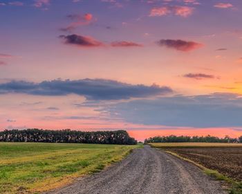
Road Access: Your parcel is served by county-maintained dirt road - legal access is confirmed. US Highway 97 and Oregon Route 140 provide the main highway corridors connecting the Oregon Pines area to the wider region.
GPS Coordinates:
Center: 42.54391, -121.41170
Corner coordinates: obtain from Klamath County GIS prior to publishing (not provided in DD report).
Zoning And Permitted Uses - Built For Freedom, Not Restrictions
Rural/Agricultural Vacant Land - Klamath County: This parcel carries Klamath County's Rural/Agricultural Vacant Land zoning designation - one of the most flexible and owner-friendly classifications available in rural Oregon. No HOA. No architectural review committee. No time limit to build. No one telling you what your structure must look like, when construction must start, or how fast it must finish.
Single-Family Home: You may build a single-family dwelling on this parcel. Site-built stick construction, manufactured, modular, and mobile homes (post-1976) are all permitted.
Manufactured, Modular, and Mobile Homes: All three are permitted under Klamath County zoning. Mobile homes manufactured prior to 1976 are not permitted. A quality post-1976 manufactured home is one of the fastest and most cost-effective routes to permanent occupancy on this parcel - set up your structure, install your utilities, and be living on your land on a timeline and budget that fits your situation.
Tiny Homes: Tiny homes are permitted with a county-approved plan. If you are planning a compact, highly efficient off-grid structure, Klamath County's planning department can guide you through the approval process for a tiny home design.
Short-Term Vacation Rentals: Permitted per county guidelines. For buyers who purchase this as an investment and choose to build and rent short-term, the proximity to Crater Lake National Park, the Williamson River, and the Fremont-Winema National Forest creates consistent and growing demand from outdoor recreation travelers seeking rural southern Oregon accommodations.
Camping and RV Use: Camping and RV parking are permitted for 21 days every 6 months without a permanent structure on site - workable for scouting visits, seasonal camping, and phased move-in planning. Full-time RV living is not permitted without a permanent dwelling.
No HOA, No Mandatory Dues, No Deed Restrictions Beyond County Zoning: There is no homeowners association in Oregon Pines with mandatory fees or enforcement authority. Your land use decisions are governed by Klamath County zoning - and Klamath County's rural zoning is designed to respect landowner rights, not restrict them.
Wildlife And Natural Environment
A Wildlife Corridor Between Two National Forests: The Oregon Pines subdivision's position between the Fremont and Winema national forests places it squarely within the wildlife movement corridor that connects Cascade highland habitats to the high-desert valleys and wetlands of the Klamath Basin. What that means practically is that the wildlife visible from this parcel is not occasional or incidental - it reflects the full ecological range of south-central Oregon operating at full scale.
Rocky Mountain Elk: Elk populations are present and documented in the Fremont-Winema National Forest immediately adjacent to the Oregon Pines community - the Klamath Falls, Keno, and Sprague Game Management Areas cover the region. Landowners in the subdivision report seasonal elk movement through the community corridors. Hunting access to the adjacent national forest is a defining benefit of ownership here.
Deer - Mule Deer and Black-Tailed Deer: Mule deer are permanent residents of the high-desert brush and forest transition zone. Black-tailed deer inhabit the denser forest country toward the Cascade crest to the west. The brushy, open terrain of Oregon Pines at 4,900 feet is classic mule deer habitat - browse species are abundant, and deer are a regular presence around the subdivision year-round.
Bear, Cougar, and Bobcat: Black bear, mountain lion, and bobcat have all been documented in the canyon and forest terrain surrounding Oregon Pines - including bear and cougar tracks in Cooks Canyon less than 1 mile from the subdivision. These apex predators indicate a healthy, intact ecosystem. For wildlife photographers and naturalists, south-central Oregon's predator diversity is exceptional.
The Klamath Basin - One of North America's Top Birding Locations: The Klamath Basin is home to six national wildlife refuges and supports more than 350 species of resident and migratory birds - making it one of the continent's premier birding destinations. The basin is positioned on the Pacific Flyway, one of the four major North American migratory bird corridors, and the resulting species diversity and seasonal abundance is genuinely extraordinary.
Bald Eagles - Hundreds in Winter: The Klamath Basin hosts one of the largest winter concentrations of bald eagles in the contiguous United States. Hundreds of birds gather each winter along the refuges and waterways of the basin - a wildlife spectacle that draws observers from across the Pacific Northwest and beyond.
Sandhill Cranes, Waterfowl, and Upland Birds: Tens of thousands of sandhill cranes pass through the Klamath Basin each spring and fall. Waterfowl - mallard, pintail, gadwall, wigeon, teal, Canada geese - fill the refuges and lakes in season. Upland birds including blue grouse, ruffed grouse, California quail, chukar, Hungarian partridge, and wild turkey are present in the appropriate habitats across the county. American white pelicans nest at Upper Klamath Lake in a colony visible from the shore.
Raptors: Golden eagle, red-tailed hawk, Swainson's hawk, ferruginous hawk, great horned owl, and prairie falcon patrol the open terrain of the high-desert and forest edge year-round. The Klamath Basin's raptor diversity is one of the most consistent in Oregon.
Pronghorn: Pronghorn antelope inhabit the open high-desert terrain east of the subdivision, providing spot-and-stalk hunting opportunities in season and regular wildlife viewing from the valley roads.
Outdoor Recreation And Nearby Attractions
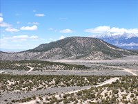
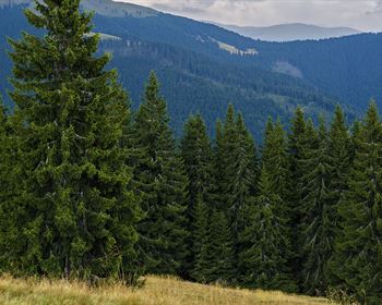
Fremont-Winema National Forest - Less Than 1 Mile Away: The 2.3-Million-Acre Fremont-Winema National Forest is the defining recreational asset of the Oregon Pines location. With the forest boundary less than 1 mile northwest of the property, you are not driving an hour to reach public land - you are stepping into it. The forest offers hundreds of miles of hiking and equestrian trails, ATV and off-road vehicle routes, dispersed camping throughout most areas without a permit, and hunting access to elk, mule deer, and upland birds across an enormous swath of south-central Oregon. The heavily timbered western portion of the forest borders the Cascade crest and Crater Lake National Park. Forest roads ranging from maintained gravel to primitive two-track open the terrain to anyone with a capable vehicle and the desire to explore.
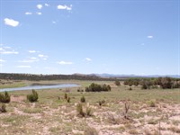
Sprague River Fishing - Beatty Area, 20 Minutes: The Sprague River runs through the Beatty community and is one of the Klamath Basin's most productive and varied fishing streams. The lower Sprague near Beatty holds rainbow trout, brown trout, largemouth bass, bullhead catfish, and yellow perch - a mix that appeals to both fly anglers and conventional tackle fishermen. Nimrod River County Park in Beatty provides public bank access to the river. The upper Sprague above Bly carries rainbow, brown, brook, and bull trout (bull trout catch-and-release only) - excellent spring fishing before summer water temperatures rise. Angling pressure on the Sprague remains light compared to better-known Oregon fishing destinations.
OC&E Woods Line State Trail - Oregon's Longest Linear State Park, 10-15 Minutes: The Oc&E Trail starts in Dairy - 10 to 15 minutes from the property - and extends approximately 100 miles northeast through the Klamath Basin, the Fremont-Winema National Forest, and toward the remote Sycan Marsh. Open year-round to hikers, cyclists, equestrians, and non-motorized recreation, the trail passes through a progression of southern Oregon landscapes: agricultural flatlands, ponderosa pine forest, and high-country terrain that few visitors see. For a landowner who enjoys trail-based recreation without driving to a trailhead, the proximity of the Oc&E starting point is a practical daily amenity.
Williamson River - World-Class Trophy Trout, 45 Minutes: The Williamson River, approximately 45 minutes west near Chiloquin, is among the most celebrated trophy fly-fishing waters in the Pacific Northwest. Native redband rainbow trout - genetically distinct from coastal rainbows and adapted to the rich alkaline waters of the Klamath Basin - grow to extraordinary sizes here. Fish routinely topping 10 pounds are not uncommon; specimens to 20 pounds have been documented. The river is spring-fed and flows crystal-clear year-round. Catch-and-release is the conservation standard for native fish. Several professional guides work the Williamson for good reason - this is genuinely world-class water within a 45-minute drive of your land.
Crater Lake National Park - Approximately 1.5 Hours: America's deepest lake (1,943 feet), Oregon's only national park, and one of the most visually extraordinary places on Earth. Crater Lake formed approximately 7,700 years ago when the summit of Mount Mazama collapsed following a catastrophic eruption, creating a caldera that gradually filled with rain and snowmelt to produce the intensely blue, phenomenally clear lake visible today. The lake is 5 by 6 miles across, surrounded by caldera walls ranging from 7,000 to 8,000 feet in elevation. Activities include Rim Drive (generally open July through October), the Cleetwood Cove Trail (the only trail descending to the lake's surface), Wizard Island boat tours, backcountry camping, snowshoeing, and cross-country skiing in winter. Fishing is permitted without a license inside the park boundaries - artificial lures and flies only, no size or number restrictions on the naturally reproducing kokanee salmon and rainbow trout in the lake. Crater Lake draws 600,000-Plus visitors annually and its national profile continues to grow - proximity to it is a durable long-term location advantage.
Upper Klamath Lake - Giant Rainbows and Waterfowl, 1 Hour: Upper Klamath Lake is Oregon's largest lake and one of the most productive native rainbow trout fisheries in North America. Redband rainbows in the lake reach salmon proportions - fish to 20 pounds are regularly taken. Fall through spring is the prime trout season; summer fish concentrate at the north end near river mouths and underwater springs. The lake is ringed by public access points, including the Upper Klamath National Wildlife Refuge, which provides boat-access waterfowl hunting in season. Mallard, gadwall, pintail, wigeon, teal, and Canada geese use the refuge in substantial numbers during fall and spring migration.
Diamond Lake - Trophy Fly Fishing and Mountain Recreation, 1.5 Hours: Diamond Lake, approximately 1.5 hours north via Us-97, is a bucket-list fly-fishing destination. Following the successful eradication of invasive tui chub baitfish by Oregon Department of Fish and Wildlife, rainbow trout fishing on Diamond Lake has rebounded dramatically. Bait fishing is prohibited - fly and lure only - making it a classic fly-angler's lake. Diamond Lake sits at the base of 9,182-Foot Mount Thielsen, known as the "Lightning Rod of the Cascades," providing hiking and mountaineering access from the lakeshore.
Lava Beds National Monument - 1.5 Hours South: Lava Beds National Monument preserves one of North America's most extensive lava tube cave systems - over 700 catalogued caves, many open to public exploration with only a headlamp and sturdy footwear. Cinder cones, spatter cones, and ancient lava fields create a volcanic landscape unlike anything else in the Pacific Northwest. The monument is historically significant as the site of the Modoc War of 1872-73, giving the landscape a human history as distinctive as its geology.
Klamath Falls Recreation Hub - 1 Hour: The Bill Scholtes Klamath Sportsman's Park in Klamath Falls offers a motocross course, four-wheel-drive and off-highway course, airfield for radio-controlled aircraft, rifle and archery shooting ranges, picnic and camping areas, and direct Klamath River fishing access - all in a single public park. The city also offers Oregon's longest zipline, the state's only Arnold Palmer-designed golf course, and the oldest birding festival in the United States. For a small city, Klamath Falls punches well above its weight for recreational amenities.
Skiing - Mount Bachelor, 2 Hours: Mount Bachelor near Bend, approximately 2 hours north via Us-97, is one of the Pacific Northwest's premier ski destinations - 3,683 skiable acres, 360-Degree terrain, and one of the region's most reliable snow bases. Winter recreation in the adjacent Fremont-Winema National Forest includes snowmobiling and snowshoeing from multiple Forest Service sno-parks much closer to home.
Utilities And Off-Grid Living
Power - Off-Grid Solar: The Practical and Cost-Effective Path: No grid power is confirmed on this parcel. Pacific Power serves the broader area and can be contacted for grid extension feasibility and cost - line extension to rural Oregon Pines lots can be substantial. The practical solution for most buyers is an off-grid solar system, and at 4,900 feet in Klamath County with over 300 days of sunshine annually, the solar resource here is exceptional. A properly sized solar array with battery storage powers a comfortable off-grid cabin, manufactured home, or tiny home reliably across all four seasons. Wind generation is available as a supplemental resource. A propane-fueled generator provides backup during extended low-production periods.
Water - Well Drilling or Water Hauling: No water source exists on site. Domestic well drilling is permitted under Klamath County regulations - buyers should engage a local licensed well driller to assess depth and flow rate expectations for the Oregon Pines area before finalizing development plans. Average well depths for the subdivision are not confirmed in the DD report; verify locally. Water hauling to a holding tank or cistern is a commonly used interim solution while a well is being permitted and drilled - this approach is straightforward and practiced widely throughout rural Klamath County.
Sewer - Septic System Required: A septic system is required for any permanent occupancy. Klamath County requires a site evaluation and permit before installation. The evaluation process identifies the appropriate system design for the parcel's soil type and site conditions. Septic installation is a standard rural development cost that most buyers budget as a known project independent of their primary structure timeline.
Propane - Heating and Cooking: Propane is the standard fuel for heating, cooking, and hot water in the Oregon Pines area. Avista serves the region as a propane provider. Propane tank installation and delivery logistics are well-established for rural Klamath County landowners.
Internet - Starlink Satellite Broadband: Starlink satellite internet provides genuine broadband-quality service throughout rural Klamath County without requiring physical infrastructure at the parcel. At 4,900 feet in open high-desert terrain, unobstructed sky access is standard - Starlink performance is consistent and reliable year-round. For remote workers, retirees staying connected, or first-time buyers who want to camp and work from their land while building toward permanent occupancy, Starlink has removed the connectivity barrier that once limited rural land utility.
Waste Removal: Waste management requires a private hauler arrangement or use of a nearby county transfer station - standard for off-grid rural parcels in Klamath County. Waste Management provides private pickup service for the area.
Climate And Terrain
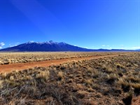
4,900 Feet in Southern Oregon - The Sweet Spot of the Cascades Transition: At 4,900 feet in south-central Oregon, this parcel sits in the open, sun-drenched transition zone where the Cascade foothills give way to the high-desert basin. Over 300 days of sunshine annually. Summer days are warm but not punishing - afternoon highs typically in the low to mid-70s, with nights cooling to the 40s and 50s. Air conditioning is not a feature of Oregon Pines cabins because it is not necessary. Winters bring snow at this elevation, creating a genuine four-season experience without the extreme cold of higher-elevation Cascade properties.
Terrain - Flat, Open, and Buildable: Lot 8, Block 8 is described as flat to level with open rural high-desert character and light woodland cover. No drainage-carved ravines, no significant slope to complicate foundation work, no terrain obstacles that require expensive site preparation before construction begins. A flat 1.64-Acre parcel at this elevation is a clean canvas - you decide where the structure goes, where the driveway cuts, where the solar array faces, and what the cleared view corridor looks like. Flood Zone X classification confirms the property is outside the 1% annual chance floodplain - no flood insurance requirement, no construction setback complications from flood overlay regulations.
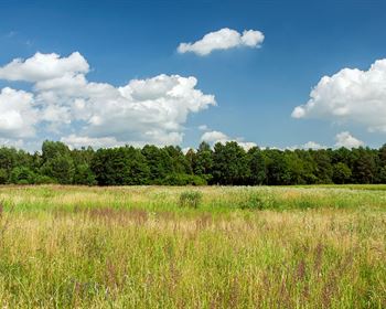
The High Desert and Ponderosa Pine Transition: At this elevation, the landscape character is open high-desert transitioning to piñon, juniper, and ponderosa pine as the terrain rises toward the Cascade crest. The Oregon Pines subdivision takes its name from the ponderosa timber that defines the regional character - tall, open-canopied pines casting dappled shade across the high-desert floor, with sage and brush in the openings. It is a landscape that photographers, painters, and writers have described as quintessentially Oregon: big sky, open ground, and an ancient forest presence that urban environments cannot replicate.
Sunshine: Klamath County's 300-Plus sunny days per year is not a tourism tagline - it is a climatic fact documented across regional weather records. The high-desert plateau position east of the Cascades creates a consistent rain shadow effect that results in clear, dry conditions that contrast sharply with the perpetually overcast valleys west of the mountains. For landowners planning off-grid solar installations, the solar irradiance data for Klamath County makes the financial case for off-grid power without ambiguity.
Community And Services
Dairy - 10-15 Minutes: A small, rural community at the edge of the Klamath Basin's agricultural heartland. Starting point for the 100-Mile Oc&E Trail. Practical and close.
Beatty - 20 Minutes: The Oregon Pines landowner's primary service stop. Grocery, post office, gas, and the Nimrod River County Park - public Sprague River fishing access you can use any day of the week without a pass or reservation. Named for missionary J.L. Beatty, the town sits near 24 historic mines and offers a small-town western character that has remained largely unchanged for generations.
Sprague River - 25-30 Minutes: Small ranching and farming community on the Sprague River. Post office, public library, a community store. The rural character of the Sprague River Valley - ranches, farms, wildlife, and river country - defines the regional identity of the area surrounding Oregon Pines.
Chiloquin - 45 Minutes: Located at the confluence of the Sprague and Williamson rivers. Gateway to the Williamson River trophy fishery. Small services.
Klamath Falls - 1 Hour: Sky Lakes Medical Center. Oregon Institute of Technology. Walmart Supercenter, Home Depot, multiple grocery chains, dining, culture. Klamath Falls Airport with connections to Portland. The full suite of urban services within a one-hour drive. The city's 300 days of sunshine per year, its historic downtown, and the Bill Scholtes Sportsman's Park make it a regional hub that delivers far more than its population size suggests.
Medford - Approximately 1 Hour 45 Minutes: Full urban amenities, Rogue Valley International-Medford Airport (Mfr) with commercial service, and access to the culturally rich Rogue Valley wine country, the Rogue River, and the Oregon Shakespeare Festival in nearby Ashland.
School District: Klamath County School District serves the Oregon Pines area.
Community Character: Oregon Pines draws the buyer who values access over amenity - hunters who want to be adjacent to the national forest, anglers who want a drive of under an hour to world-class water, remote workers who want Starlink connectivity and wide-open skies, and first-time buyers who have wanted land for years and are ready to act on it. There is no HOA shaping the community's character. The land does that.
The Investment Case
$49 Per Year to Hold. No HOA. No Assessments: The annual carrying cost of this parcel as vacant land - taxes plus a minimal liability policy - is under $75 per year. There is no cheaper way to hold Oregon land. The patience required to wait for appreciation costs almost nothing here. For buyers who purchase and hold while deciding on their development timeline, the economics of waiting are essentially zero.
National Park Proximity - A Durable Long-Term Value Anchor: Crater Lake National Park is approximately 1.5 hours from this parcel. Properties within reasonable proximity of major national parks carry structural premiums over comparable rural land without that anchor - a pattern documented consistently across national park markets throughout the American West. Crater Lake draws 600,000-Plus visitors annually and continues to grow its national and international recognition. That demand does not diminish.
Fremont-Winema National Forest Adjacency: Direct adjacency to 2.3 million acres of national forest is a quantifiable location premium. Hunters pay access fees, lease fees, and guide fees to reach the same public land that this parcel delivers by proximity alone. Anglers planning Williamson River trips need a base of operations - this parcel is a logical base 45 minutes from the river. The forest adjacency adds recreational utility value beyond the real estate value of the parcel itself.
California Migration Pattern - Southern Oregon's Quiet Opportunity: Rural southern Oregon has received sustained attention from California buyers over the past decade - buyers seeking affordable land, lower taxes, less regulatory burden, and proximity to the outdoor recreation that drew them to the West Coast in the first place. Klamath County offers all of that. The land price gap between comparable Northern California rural properties and Klamath County parcels at equivalent recreational proximity remains significant - that gap will not persist indefinitely as buyer discovery continues.
Multiple Exit Strategies: Build and occupy. Build and short-term rent, leveraging Crater Lake proximity for consistent vacation rental demand. Hold vacant at near-zero cost and resell. The Rural/Agricultural zoning and the absence of HOA restrictions preserve full option value across all three strategies.
Your Three Paths To Ownership - No Credit Check, No Bank Required
Option 1 - Cash Purchase
Best Total Value - Immediate Full Ownership
Cash Sale Price: $8,997 (reduced from $12,999)
Down Payment: $299
Documentation Fee: $250
Total Due Today: $549
Conveyance: Recorded Warranty Deed after closing
---------------------------------------------------------------
Option 2 - Super Saver Financing
Best Value With Financing - Fastest Path to Full Ownership
Monthly Payment: $416
Loan Term: 2-Year Super Saver Plan
Total Monthly Payments: $399 x 30 months
Down Payment: $399
Documentation Fee: $250
Total Due Today: $649
Own your Oregon land free and clear in 2 years.
---------------------------------------------------------------
Option 3 - Easy Financing
Lowest Entry Point - Start for $438 Today
Monthly Payment: $205
Loan Term: 8-Year Easy Financing Plan
Total Monthly Payments: $188 x 96 months
Down Payment: $188
Documentation Fee: $250
Total Due Today: $438
Your Oregon land. $438 to start. $205 a month to own it.
---------------------------------------------------------------
All Three Plans Include:
No Credit Check - Your credit history is not a factor.
No Bank Involvement - No applications, no appraisals, no denials.
No Prepayment Penalties - Pay it off early at any time at no extra cost.
Simple Process - Reserve today. Paperwork in one to two business days.
Perfect For Buyers Who Want
First Land Ownership Made Accessible: Own Oregon land for $188 down, $205/Month, no credit check - the most direct ownership path available.
A National Forest Backyard: Less than 1 mile to Fremont-Winema National Forest - 2.3 million acres of hiking, hunting, camping, and riding immediately adjacent to your property.
World-Class Fishing Access: Sprague River rainbow and brown trout 20 minutes away. Williamson River trophy redbands to 20 pounds at 45 minutes. Crater Lake kokanee at 1.5 hours.
Elk Hunting Basecamp: GMU access to Klamath Falls, Keno, and Sprague Game Management Areas with national forest hunting land a short drive from the property.
Crater Lake Country: The deepest lake in America and Oregon's only national park at 1.5 hours - a national park proximity premium that few rural land listings in Oregon can match.
Oregon Trail Access: Step on the 100-Mile Oc&E Trail starting in Dairy, 10-15 minutes away - Oregon's longest linear state park for hiking, cycling, and equestrian use.
Off-Grid Self-Sufficiency: Flat buildable land, 300+ sunshine days, solar-ready terrain, well drilling permitted - all the practical inputs for a genuine off-grid lifestyle.
Zero-Overhead Land Banking: $49/Year taxes. No HOA. No assessments. Hold this land at near-zero cost while it appreciates alongside Oregon's growing recreational land demand.
Starlink-Ready Rural Escape: Unobstructed sky, 4,900 feet, open high-desert - ideal Starlink conditions for remote workers who want solitude without sacrificing connectivity.
Take Action - Your Oregon Land Starts At $438
What You Are Getting: 1.64 flat, level acres in the Oregon Pines subdivision of Klamath County, Oregon. Elevation 4,900 feet. Rural/Agricultural zoning - no time limit to build, no HOA. Direct frontage on county-maintained road. National forest less than 1 mile away. Annual taxes of $49. No back taxes, no liens. Sprague River trout fishing 20 minutes away. Oc&E Trail 10-15 minutes away. Williamson River trophy rainbows 45 minutes away. Crater Lake National Park 1.5 hours away. Off-grid solar country with 300+ sunny days per year. Owner financing from $188 down - no credit check, no bank required.
Why This Will Not Wait: 1.64-Acre parcels in the Oregon Pines subdivision with legal road access, no HOA, and Rural/Agricultural zoning at this price point represent a shrinking inventory category. As California and Pacific Northwest buyers continue discovering southern Oregon's value-recreation equation, entry-level Klamath County parcels near the Fremont-Winema National Forest do not remain underpriced indefinitely. At $8,997 cash or $438 to start financing, the price is not going to get lower than this.
Your Next Move: Drop the GPS coordinates into your maps - 42.54391, -121.41170. Drive out when you can. Walk the flat ground, look west toward the Cascade timber, and listen to what 4,900 feet of southern Oregon quiet sounds like. Then contact us and make it yours.
100-Day No-Nonsense Guarantee
When you purchase this property and change your mind within 100 days of your down payment, let us know. We will either refund your principal payment or exchange it for another property in our inventory that better suits your needs. This guarantee allows you to secure the property confidently before visiting in person. On owner financing, we refund principal paid excluding fees (closing costs, doc fees, note maintenance fees, and taxes). Any late or missed payments during the guarantee period will automatically void the guarantee.
The forest is a mile away. The river is twenty minutes. The lake is ninety. The land is yours for $438.
Start living wild - your Oregon adventure begins today.
Note: Information presented in this listing is deemed accurate but not guaranteed. Buyers are advised to conduct their own due diligence and verify all details independently. Property is sold as-is where-is.
Annual Ownership Costs
Property Taxes: $49.00/Year (2025) - approximately $4.08/Month
HOA Fees: $0 - no HOA
Special Assessments: $0
Metro District Taxes: $0
Transfer Fees: $0
Mandatory Road Maintenance Fees: $0
Land Maps & Attachments
Directions to Land
Directions To Apn R276597
Oregon Pines, Block 8, Lot 8
Dairy, OR 97625
GPS Center: 42.54391, -121.41170
Gps Corner Coordinates
Center: 42.54391, -121.41170
CORNERS: Not provided in DD report - obtain from Klamath County GIS before publishing.
GIS link:
PRIMARY STARTING POINT - KLAMATH FALLS, OR (approx. 1 hour)
1. Start in Klamath Falls, Oregon at the US-97 / OR-140 interchange.
2. Head EAST on Oregon Route 140 (toward Keno and Sprague River) for approximately 42 miles.
3. At the community of Dairy, look for signs for the Oregon Pines subdivision roads heading NORTH off OR-140.
4. Turn NORTH onto the appropriate Oregon Pines subdivision road (county-maintained dirt road).
5. Navigate to Lot 8, Block 8 using GPS: 42.54391, -121.41170.
Note: Confirm the specific turn street name from Klamath County GIS or the recorded plat map for Oregon Pines Block 8 prior to visiting. GPS navigation to center coordinates is recommended once you enter the subdivision.
SECONDARY STARTING POINT - BEATTY, OR (approx. 20 minutes)
1. Start in Beatty, Oregon at the OR-140 / Beatty junction.
2. Head WEST on OR-140 toward Dairy for approximately 8-10 miles.
3. Watch for Oregon Pines subdivision road signs heading NORTH off OR-140.
4. Turn NORTH and navigate to Lot 8, Block 8 using GPS: 42.54391, -121.41170.
SECONDARY STARTING POINT - MEDFORD, OR (approx. 1 hour 45 minutes)
1. From Medford, Oregon, head EAST on OR-140 (White Lake Road / Klamath Highway) toward Klamath Falls.
2. Continue east through Butte Falls and Lake of the Woods, passing over the Cascade crest.
3. Continue east past Klamath Falls to OR-140 East toward Beatty and the Sprague River Valley.
4. At Dairy, turn NORTH onto Oregon Pines subdivision road.
5. Navigate to GPS: 42.54391, -121.41170.
Road Conditions And Vehicle Notes
Oregon Pines internal roads are county-maintained dirt roads. Passable under normal conditions in a standard passenger vehicle during dry weather. A high-clearance vehicle is recommended during or after rain, snow, or spring thaw. In winter months, four-wheel drive or chains may be required depending on conditions.
Fuel: Nearest gas station is in Beatty (approximately 20 minutes east on OR-140). Top off in Klamath Falls or Beatty before heading into the subdivision.
More Land Details
More Land from Collin Pettet
-
 5.1 AC : $15K
 - 5.7 AC : $10K
- 5.6 AC : $8.5K
- 0.2 AC : $9K
- 0.2 AC : $9K
- 5.3 AC : $19K
- 5.1 AC : $8.5K
- 1 AC : $8.5K
- 6.2 AC : $34.2K
- 5.4 AC
- 0.2 AC : $9K
- 1 AC : $8.5K