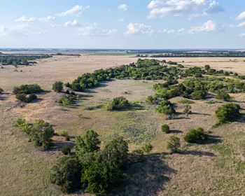
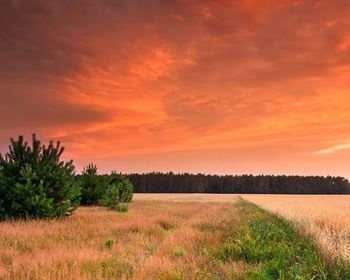
Treed Gated Lot, Sand Dunes CO
25 Mill Run Rd : Mosca, CO 81146
Alamosa County, Colorado
Land Description
Land Description
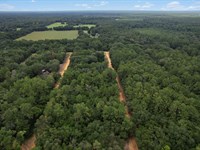
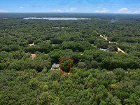
Picture this: You wake up to mountain silence, step outside into crisp high-altitude air, and the Sangre de Cristo Mountains fill your entire eastern horizon. The Great Sand Dunes - North America's tallest, rising 750 feet from the valley floor - are 13 minutes down the road. You're inside a gated community framed by big, mature trees, and last night you streamed a movie in perfect quality on the fiber optic connection running right to your street. This isn't a fantasy version of Colorado living. This is 25 Mill Run Road, Mosca - and it can be yours for $14,999.
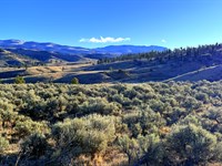
This 1.02-Acre lot in the Zapata Homeowners Association sits closer to Great Sand Dunes National Park and Preserve than any other private community in the San Luis Valley, positioned right at the base of the Sangre de Cristo Mountains at 7,921 feet. The Zapata HOA is one of the most established and organized private communities in southern Colorado - governing documents dating back to 1975, an active leadership team, regular community events, board meetings, and a members-only website with newsletters, a wildlife guide, and a welcome packet that greets every new owner. This is not a loose collection of raw lots. This is a real, governed, connected community with a gate code, a Facebook group, and neighbors who care about where they live.
What makes this parcel stand out from every other piece of land available in the San Luis Valley is the combination of infrastructure that simply does not exist elsewhere at this price. Fiber optic internet service runs to the street at your lot - real broadband, not satellite. Power runs right across the street with a close connection point, making grid hookup dramatically simpler and cheaper than the distant transformer situations found on most rural land. The mature trees throughout the community took decades to grow and cannot be replicated. The gated access provides security and peace of mind that open subdivisions cannot offer. Add in the base-of-mountain position, the national park proximity, and annual taxes of just $296.40, and the value picture becomes clear.
The Zapata HOA has been an established community since 1975, with covenants, architectural requirements, and general policies that protect the character and value of every lot. Minimum lot size for residential construction is 1 acre - your 1.02-Acre parcel meets this threshold exactly. Minimum residential construction size is 950 square feet. Camping is permitted up to 14 days annually with a septic system. The community has a wildlife section in its welcome packet - elk, deer, and the remarkable wildlife of the San Luis Valley are part of daily life here. An active events calendar and regular board meetings mean this is a living, breathing neighborhood, not just a land investment on paper.
Whether you are drawn here as a recreational getaway, a Colorado second home, or the place to finally put down roots for a quiet and beautiful retirement, this parcel meets all three visions. The Great Sand Dunes for weekend adventure. Zapata Falls 16 minutes away for a morning hike. World-class stargazing from your own property under some of Colorado's darkest skies. And when the day is done, you come home through the gate, under the canopy of mature trees, to your piece of one of the most spectacular landscapes on the continent.
Cash Price: $14,999
For financing options, click the green "Land Website" button located under "Land Maps and Attachments" just above the Directions section at the bottom of this page.
See Info below:
- Total Acreage: 1.02 acres
- Parcel Configuration: Rectangular lot, approx. 330 ft x 350 ft
- Short Legal: Lot 34, Zapata Subdivision (Zapata Unit 2 Tr 15 Blk RV 1)
- Subdivision: Zapata HOA - Established Gated Community (est. 1975)
- State: Colorado
- County: Alamosa
- Zip: 81146
- Approximate GPS Coordinates (Center): 37.648060, -105.578360
- Corner Coordinates: NW: 37.648365, -105.578785 | NE: 37.648297, -105.577926 | SW: 37.647781, -105.578796 | SE: 37.647824, -105.577935
- Elevation: Approximately 7,921 feet above sea level
- Terrain Type: Flat to gentle slope - Valley Grassland - easy development
- Annual Taxes: $296.40/Year
- Zoning: Low-Density Residential (Rl) - Alamosa County
--- Single-family homes, modular and double-wide manufactured homes permitted
--- Tiny homes allowed (950 sq ft minimum per HOA; 500 sq ft per county)
--- Short-term vacation rentals permitted with valid business license
--- No timeline to build
--- Outside Fema flood zone
- HOA: Zapata HOA ($180/Yr) - established 1975, active governance, events calendar, gated access, wildlife community, road maintenance and grading
- Fiber Optic: Service at the street - high-speed internet at your lot line
- Electric: Power running right across the street - close grid connection point available; contact Xcel Energy ) or San Luis Valley Rural Electric Cooperative
- Water: Well or cistern required - avg depth 150-350 ft
- Sewer: Septic required - county-approved installation
- Solar: Permitted and highly efficient at this elevation
- Gas: Propane - contact Conejos Propane or AmeriGas
- Rainwater Collection: Legal in Colorado per applicable restrictions
Note: Information presented in this listing is deemed accurate but not guaranteed. Buyers are advised to conduct their own due diligence, review the Zapata HOA governing documents at and verify all details independently.
---
Location And Setting Overview
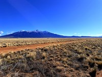
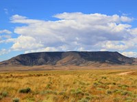
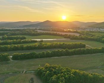
The Most Privileged Private Position Near Great Sand Dunes: The Zapata HOA sits closer to Great Sand Dunes National Park and Preserve than any other private community in the San Luis Valley - 7.7 miles from the park visitor center, at the literal base of the Sangre de Cristo Mountains. This is not a marketing approximation. It is a geographic fact that no other gated community in the region can claim. The 750-Foot dunes are visible from within the community. The mountain ridgeline fills your eastern sky. On clear nights - which are most nights at this elevation and latitude - the Milky Way stretches from one end of the valley to the other in a sky so dark that Great Sand Dunes National Park carries official Dark Sky Park designation from DarkSky International.
An Established Community with Real Character: The Zapata HOA has been a governed, organized community since 1975 - over five decades of sustained ownership and stewardship. The covenants (updated in 1981), architectural requirements, general policies, and active leadership team reflect a community that takes its character seriously. There is a formal welcome packet for new owners. An events calendar. Regular board and committee meetings. A wildlife guide. A Facebook community group. These are not the hallmarks of a speculative raw land subdivision - they are the hallmarks of a place where people actually live, visit, and belong.
The mature trees that shade and define the community are the most visible result of that long history. Trees at this elevation in the high desert San Luis Valley take decades to reach the size found throughout the Zapata HOA. They cannot be planted and grown in a development timeline. They are here because the community has been here, cared for, and tended since 1975. For buyers, that maturity is irreplaceable.
Infrastructure Ready - Not Starting From Zero: Most rural Colorado land investments begin with a long, expensive infrastructure development process before any enjoyment or rental income is possible. Fiber optic internet at the street and power running right across the road with a close connection point compress that timeline dramatically. You are not starting from zero - you are starting from a position that most rural landowners spend years and significant money trying to reach. For remote workers, retirees, and vacation rental operators alike, these infrastructure advantages translate directly into faster timelines, lower development costs, and earlier enjoyment of the investment.
The San Luis Valley - Colorado's Best-Kept Secret: While Summit County, Eagle County, and even Chaffee County have priced out most individual buyers, the San Luis Valley remains one of the last genuinely affordable corners of a state where land values have surged nearly everywhere else. Great Sand Dunes National Park visitation grows every year. The valley's extraordinary dark skies, cultural depth, and dramatic mountain backdrop are earning wider national recognition. The Zapata HOA's position at the very closest point to the park, in a gated community with mature trees and established infrastructure, places it at the front of any appreciation wave that comes.
---
Why This Parcel, Why Now
Three Buyers. One Perfect Property: Every person who discovers this listing falls into one of three categories, and this parcel serves all three equally well.
The Recreational Getaway Buyer has been looking for a Colorado base camp within an hour of everything - national park, mountain trails, fishing, stargazing, ski proximity in winter - without paying Front Range prices or dealing with a bare dirt lot. The Zapata HOA delivers that. Pull through the gate, breathe the mountain air, and the Great Sand Dunes are 13 minutes away.
The Second-Home Buyer wants a genuine Colorado property with real infrastructure - fiber optic internet for remote work, close grid power, a community with governance and accountability, and natural beauty that photographs well and lives even better. This parcel has all of it, in a community that has maintained its character for over 50 years.
The Retirement Buyer is searching for the place to establish themselves quietly, beautifully, and permanently - where the pace slows down, the views are extraordinary, the community is warm and organized, and the outdoor life is genuinely accessible. The Zapata HOA's active events calendar, neighbor network, and mountain setting is exactly the retirement environment that Front Range and out-of-state buyers search for and rarely find at this price.
The Zapata HOA Difference: Most land listings in the San Luis Valley are bare parcels with dirt road access and nothing else. The Zapata HOA offers organized governance with covenants dating to 1975. Gated access with a member code. An active events calendar and real community social life. A formal welcome packet and member website. Wildlife guides and neighborhood resources. Road maintenance and grading included in the $180 annual dues. A minimum 1-acre lot requirement that protects the open, spacious character of the community. The only place to get all of this, this close to Great Sand Dunes, under a canopy of mature trees at the base of the Sangre de Cristo Mountains, is right here.
---
Recreational Opportunities
Great Sand Dunes National Park - 13 Minutes Away: North America's tallest sand dunes - 750 feet high, covering 30 square miles - are your nearest major neighbor. Open 365 days a year. Sandboarding, hiking the ridgelines, wading in Medano Creek during spring snowmelt, wilderness backpacking in the adjacent Preserve, ranger-led programs, and official Dark Sky Park stargazing. Over 500,000 visitors annually and growing. No private community in the San Luis Valley sits closer.
Zapata Falls - 16 Minutes Away: A narrow slot canyon hike leads to a dramatic hidden waterfall just 6.2 miles from your front gate. Consistently rated among southern Colorado's top short hikes. The kind of discovery that keeps guests raving and returning.
Sangre de Cristo Mountains - At Your Doorstep: The Sangre de Cristo range - home to multiple 14,000-Foot summits including Crestone Peak and Crestone Needle - begins where your horizon ends. Trailheads into the 226,000-Acre wilderness are within reach. Elk, mule deer, pronghorn, and black bears are documented residents of the valley and mountains surrounding the community.
Stargazing - World-Class Dark Skies: At 7,921 feet in one of Colorado's most sparsely populated counties, with the national park's Dark Sky designation nearby, the night sky here is among the finest in the continental United States. Astrophotographers travel from across the country to photograph exactly this sky. It is yours every night.
Year-Round Colorado Life: Warm, dry summers perfect for dunes and hiking. Golden aspen fall in the surrounding mountains. Taos Ski Valley 90 minutes south. Wolf Creek - Colorado's snowiest resort - 2 hours west. Wildlife and sandhill crane migrations in spring and fall. This is genuine four-season Colorado living, not a seasonal property.
---
Building And Development Options
Your 1.02-Acre lot meets the Zapata HOA's minimum 1-acre threshold for residential construction - a meaningful distinction in a community where lot size governs what you can build. Minimum residential construction size per HOA is 950 square feet. Single-family homes, modular homes, and double-wide manufactured homes are permitted with standard setbacks and architectural review. Short-term vacation rentals are permitted with a valid business license.
With fiber optic at the street and power across the road with a close connection point, your utility infrastructure foundation is largely in place before you break ground on anything else. Drill a well (average 150-350 feet in this area), install septic, connect to the grid or go solar - and your lot is fully serviced. Solar performs exceptionally well at this elevation and latitude, and small wind generators are also permitted.
Open fires are not permitted per Zapata HOA policy - plan for propane heating and cooking. Camping is allowed on your lot up to 14 days annually with a septic system in place.
---
Investment And Market Analysis
At $14,999 with $296.40 in annual taxes and $180 in HOA dues covering road maintenance, gating, and community governance, your annual carrying cost for this property is $476.40. That is the cost of holding 1.02 acres in a gated community with fiber optic at the street, power across the road, mature trees, and the closest private position to Great Sand Dunes National Park.
Land in the San Luis Valley near Great Sand Dunes is still priced at a significant discount to comparable national park-adjacent land in most other Colorado counties. As visitation to Great Sand Dunes grows and regional awareness expands, that discount narrows. Properties in organized, established communities with infrastructure advantages lead the appreciation curve. The Zapata HOA, with its 50-year history and unique geographic position, is well placed to benefit from that trajectory.
Multiple exit paths are available at every stage - raw land appreciation, improved lot resale, vacation rental income, second home enjoyment, or retirement use. The national park proximity, established community, and infrastructure advantages create a buyer pool that extends far beyond the local market.
---
Take Action
Cash Price: $14,999. Annual taxes: $296.40. HOA: $180/Year. Total annual carrying cost: $476.40. Fiber optic at the street. Power across the road. Gated community. Mature trees. 13 minutes to Great Sand Dunes. Base of the Sangre de Cristo Mountains. Established community since 1975 with active governance, events, and neighbor network.
For financing options, click the green "Land Website" button under "Land Maps and Attachments" just above the Directions section at the bottom of this page.
100-Day Guarantee: If for any reason you change your mind within 100 days, we will refund your principal payments or work with you to exchange for another property in our portfolio. We stand behind the value this property represents - completely.
This is the one that checks every box - infrastructure, community, setting, proximity, and price. The gate closes behind you. The mountains are right there. The dunes are 13 minutes away. And it is all yours.
Start living wild. Your Colorado story starts today.
---
Information provided is deemed reliable but not guaranteed. Buyers should perform their own due diligence, review Zapata HOA governing documents at contact the HOA at or and verify all property details independently before purchase. HOA architectural requirements, covenants, and policies govern development and use - review these prior to purchase. Consult qualified tax, legal, and financial advisors regarding your specific situation. Your success is our priority.
Land Maps & Attachments
Directions to Land
Directions to Land
FROM DENVER (approximately 3 hours 45 minutes, 240 miles):
Take I-25 S from Denver toward Pueblo for approximately 100 miles to Exit 52 for US-160 W toward Walsenburg/Alamosa. Turn right onto US-160 W and continue approximately 100 miles through Walsenburg, over La Veta Pass, and through Fort Garland toward Alamosa. In Alamosa, continue east on US-160 E for approximately 14 miles to the junction with CO-150 N. Turn left (north) onto CO-150 N and continue approximately 8 miles. Turn left onto Lake of the Falls Pkwy, then turn right onto Mill Run Rd. Property is located at 25 Mill Run Rd on the right.
Gps: 37.648060, -105.578360
FROM COLORADO SPRINGS (approximately 2 hours 45 minutes, 170 miles):
Take I-25 S from Colorado Springs toward Pueblo for approximately 45 miles to Exit 52 for US-160 W in Walsenburg. Turn right onto US-160 W and continue approximately 100 miles over La Veta Pass through Fort Garland toward Alamosa. Continue east on US-160 E for approximately 14 miles past Alamosa to the junction with CO-150 N. Turn left (north) onto CO-150 N and continue approximately 8 miles. Turn left onto Lake of the Falls Pkwy, then turn right onto Mill Run Rd. Property is located at 25 Mill Run Rd on the right.
Gps: 37.648060, -105.578360
FROM PUEBLO (approximately 2 hours, 120 miles):
Head south on I-25 S to Exit 52 for US-160 W toward Walsenburg/Alamosa. Turn right onto US-160 W and continue approximately 100 miles over La Veta Pass and through Fort Garland. Continue east on US-160 E for approximately 14 miles past Alamosa to the junction with CO-150 N. Turn left (north) onto CO-150 N and continue approximately 8 miles. Turn left onto Lake of the Falls Pkwy, then turn right onto Mill Run Rd. Property is located at 25 Mill Run Rd on the right.
Gps: 37.648060, -105.578360
FROM ALAMOSA (approximately 30 minutes, 16 miles):
Head east on US-160 E for approximately 14 miles to the junction with CO-150 N. Turn left (north) onto CO-150 N and continue approximately 8 miles. Turn left onto Lake of the Falls Pkwy, then turn right onto Mill Run Rd. Property is located at 25 Mill Run Rd on the right.
Gps: 37.648060, -105.578360
More Land Details
More Land from Collin Pettet
 5.1 AC : $15K
- 1.7 AC : $20K
- 5.7 AC : $10K
- 5.6 AC : $8.5K
- 0.2 AC : $9K
- 0.2 AC : $9K
- 5.1 AC : $8.5K
- 1 AC : $8.5K
- 1.6 AC : $9K
- 0.2 AC : $9K
- 5.4 AC
- 1 AC : $8.5K