Power & 1 Mile From Reservoir
Fort Garland, CO 81133
Costilla County, Colorado
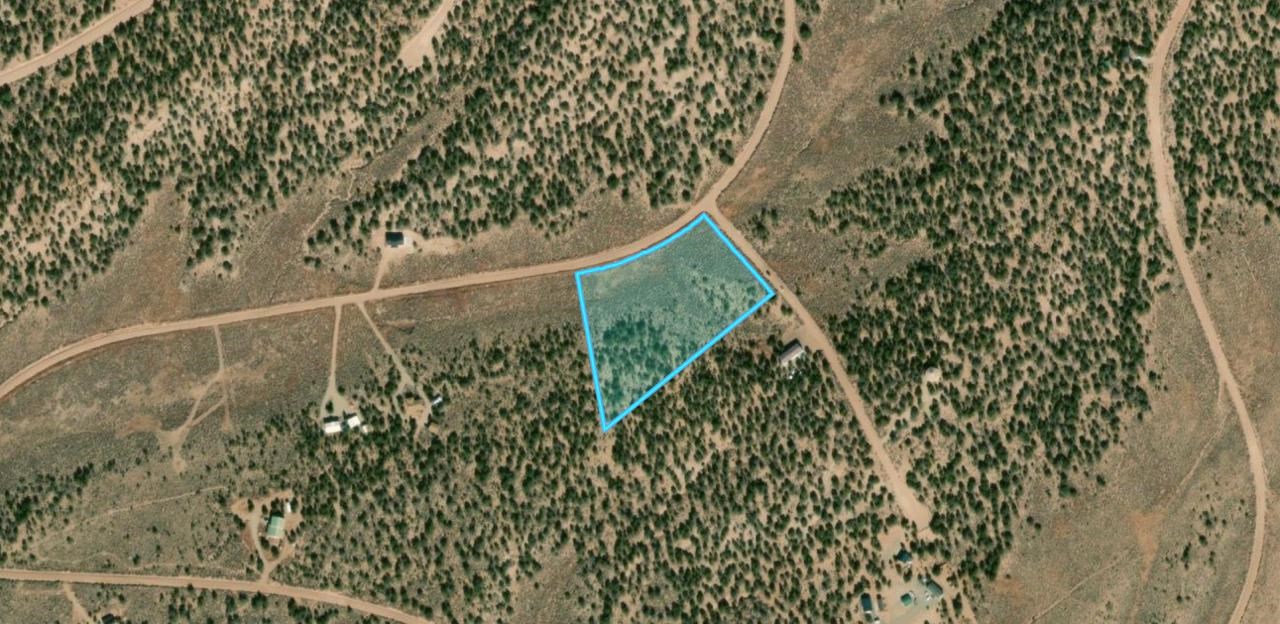
Land Description
You've probably had this picture in your head for a while.
A small piece of land in Colorado. Quiet. Open. Enough room to breathe. The kind of place where you stop checking your phone because the view in front of you is better than anything on the screen.
At first, maybe you drive up a few times a year. Then it becomes the trip everyone starts looking forward to. And somewhere along the way, it stops feeling like a vacation spot and starts feeling like the place you're headed.
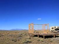
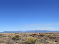
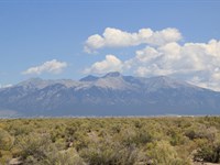
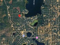
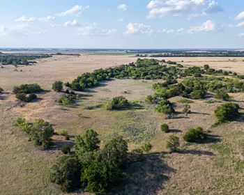
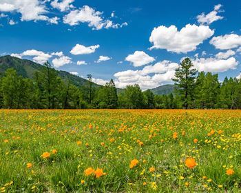
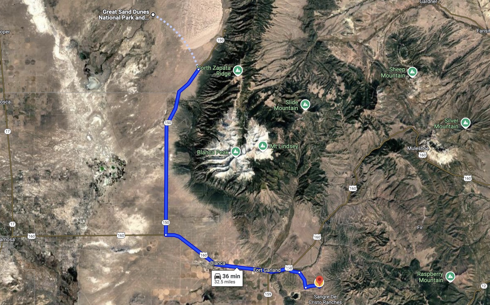
This is 5.11 acres in Sangre de Cristo Ranches in Costilla County, Colorado. The property sits at 8,398 feet, tucked behind a line of low hills in a part of the subdivision that feels more enclosed and private than the wide-open valley floor.
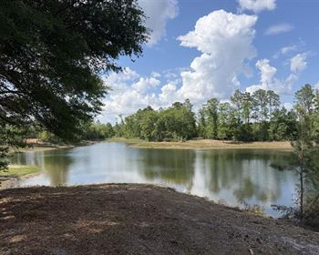
The roads in are good. The land is clean and open, with minimal vegetation. The Sangre de Cristo peaks are right there in full view. Mountain Home Reservoir is just 2.8 miles away, and Fort Garland is about 10 minutes down the road.
Good access. Natural privacy. Water nearby. A little more elevation than most parcels in the area. That mix is not something you find on every lot out here.
And you don't have to build right away.
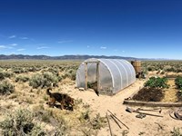
Maybe the first season is simple. You camp on your own land. No checkout time. No crowded campground. No reservation needed. You walk the property, notice where the morning light hits, and find the spot where you'd want to sit and look at the mountains.
Then the cabin idea starts to take shape.
Not just “someday.” Something real. A size. A layout. A porch facing the peaks. Eventually, it becomes a place you can come back to for the rest of your life.
The cost to hold the land while that dream comes together is low: about $19 a month in property taxes. There is no HOA and no mandatory dues.
You can start with $300 down and $340 a month. No bank. No credit check. Once the note is paid in full after 72 months, a warranty deed is recorded in your name with Costilla County. At that point, you own the property free and clear.
That's the whole transaction.
If this sounds like the picture you've been carrying around, keep reading. Or send us a message first. We're real people, and we'll get back to you.
Location: The San Luis Valley
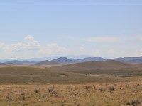
The San Luis Valley is one of the largest high-altitude basins in the world - roughly 8,000 square miles of flat valley floor surrounded by two mountain ranges. The Sangre de Cristo Mountains form the eastern wall. The San Juan Mountains rise to the west. The Rio Grande runs through the middle. The whole thing sits between 7,500 and 8,000 feet above sea level.
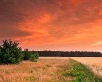
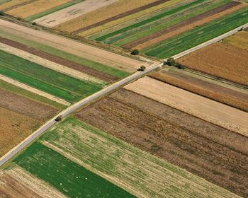
People who have never been here sometimes picture a dry, brown nothing. That is not quite right. The valley floor is high desert - short grasses, sage, and rabbitbrush as far as you can see in most directions - but the mountains at the edges are forested and streaked with snow well into spring. The contrast is part of what makes this place feel unlike anywhere else in Colorado.
The climate runs on its own schedule. The valley gets around 7 to 10 inches of precipitation annually, most of it arriving as afternoon thunderstorms in July and August. There are more than 300 sunny days a year. The air is dry. Summers are warm during the day and cool enough at night to sleep without air conditioning. Winters bring cold and snow, but the combination of low humidity and consistent sunshine means roads clear faster here than in most of the state.
The daily temperature swing is significant. A summer day might reach 80 degrees by early afternoon and drop to 45 by midnight. If you are coming from a humid climate, the dryness takes some adjustment - in a good way, most of the time.
This is not the green, forested Colorado of the mountain brochures. The beauty here is different: big sky, long views, quiet evenings, and a quality of light that photographers and painters have been coming to the valley to chase for generations. People who fall in love with it tend to fall hard. People who do not usually figure that out on their first visit, which is one reason we suggest going to see the land before you finalize your purchase.
Location: Costilla County
Costilla County sits in the southern San Luis Valley and carries more history per square mile than most places in Colorado.
In 1843, the Mexican government granted nearly 1.4 million acres in this region to Narciso Beaubien and Charles Bent under what became known as the Sangre de Cristo Land Grant. The grant changed hands over the decades that followed, but the people who had already settled the valley - Hispanic families with roots running back to New Mexico and, through New Mexico, to colonial Spain - stayed. They built acequia systems to bring snowmelt from the mountains to their fields. They established communal grazing land. Their descendants still live here.
San Luis, founded in 1851, is Colorado's oldest continuously occupied town. The San Luis People's Ditch, which still carries water to farms in town, is the oldest continuously used water right in Colorado - senior to every water claim that came after it. La Vega, the communal pasture on the edge of San Luis, is the only remaining common land of its kind in the United States. It is still used by local families under rights that date to the original land grant.
In 2009, Congress designated the region as the Sangre de Cristo National Heritage Area, recognizing the cultural significance of the valley's Hispano heritage and its agricultural traditions.
Property taxes in Costilla County are among the lowest in Colorado. The county is clear about its rules and generally accessible to landowners who want to understand them. For questions about zoning, you can call Costilla County Planning and Zoning at.
Location: Sangre De Cristo Ranches
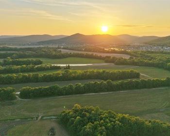
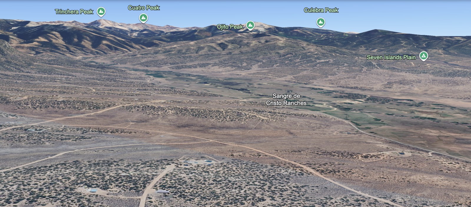
Sangre de Cristo Ranches sits in the eastern portion of the San Luis Valley, closer to the Sangre de Cristo Mountains than most other subdivisions in the region. This proximity to the mountains creates several advantages: slightly higher elevation, better mountain views, closer access to national forest land, and terrain that tends to be more varied than the flatter valley floor parcels.
Most Sdcr parcels range from 5 to 35 acres and sit between 7,800 and 8,400 feet elevation. The higher elevation means slightly cooler summers, more reliable snowfall in winter, and terrain that often includes gentle slopes and rolling hills rather than perfectly flat grassland. Many lots offer direct views of the Sangre de Cristo peaks, including several of Colorado's fourteeners.
The subdivision benefits from its position between the valley floor and the foothills. You get the open space and big sky character of the high desert, but with mountain access that many other valley subdivisions cannot match. Hiking trails, fishing streams, and wilderness access are typically closer from Sdcr parcels than from properties further west in the valley.
Access roads within Sangre de Cristo Ranches are maintained dirt and gravel. The main routes connect to Highway 160 and several county roads that provide year-round access to Alamosa, Fort Garland, and the broader region. During dry conditions and normal winter weather, a standard truck or SUV handles the roads without issue. Spring mud season - typically April through May - can make high-clearance or four-wheel drive the better choice.
The subdivision attracts buyers who specifically want mountain proximity: hunters who appreciate closer access to elk habitat, hikers and outdoor enthusiasts, buyers planning mountain-style homes that take advantage of views and elevation, and families who want the valley's affordability with more of a foothill character.
Mountain Access And Wilderness
Sangre de Cristo Ranches' location provides better access to high country recreation than most other San Luis Valley subdivisions. The Sangre de Cristo Wilderness boundary runs roughly 10 to 20 miles east of most Sdcr parcels, making day trips to wilderness areas practical.
Several trailheads access the Sangre de Cristo range from this side of the valley. The Great Sand Dunes National Park and Preserve backcountry is within an hour's drive from most Sdcr parcels. Medano Creek, which feeds the dunes, provides seasonal water access and a different hiking experience than the drier valley floor.
For families interested in introducing kids to mountain activities, the closer access means day trips rather than overnight expeditions. Fishing in mountain streams, hiking to alpine lakes, and seasonal activities like snowshoeing become more practical when the drive to trailheads is 30-45 minutes instead of 1-2 hours.
The higher elevation of Sdcr parcels also means the transition from high desert to montane ecosystems happens more gradually. You see aspen groves, pine stands, and more diverse vegetation than on the flatter valley floor. Wildlife patterns reflect this mountain influence, with elk moving closer to Sdcr parcels during winter months and more diverse bird species using the varied habitat.
This mountain access is worth factoring into your land purchase decision. Buyers who prioritize outdoor recreation, hunting, and wilderness access typically find Sdcr parcels more suitable than properties further from the mountains, though they pay slightly more for that location advantage.
Building And Land Use
Estate Residential zoning in Costilla County allows a range of building options on Sdcr parcels:
Site-built frame homes are allowed with a 600 square foot minimum and permanent foundation required. Manufactured homes are permitted if they are 1976 or newer, state-certified, and placed on a permanent foundation. Modular homes follow the same foundation requirement. Short-term rentals like Airbnb and Vrbo are allowed as long as all structures meet zoning, building, and occupancy permit requirements.
The higher elevation and more varied terrain in Sdcr create some additional building considerations. Frost depth extends deeper than on the valley floor - typically 36 to 42 inches - which affects foundation requirements. The varied topography offers more options for home placement but may require more site preparation than perfectly flat lots.
RV occupancy is permitted for up to 14 days within any 3-month period without a permit. Longer stays are allowed with an approved septic system and a temporary long-term camping permit valid for 90 days and renewable up to 5 times. Tent camping follows the same 14-day rule without a permit.
What is NOT allowed: tiny homes below 600 sq ft, container homes, pallet structures, or permanent dwellings without a foundation.
Build timeline: Construction must be completed within 3 years from the date the first permit is issued. There is no deadline to pull the permit in the first place - you can buy the land now and wait until your timing is right before starting the permit process.
Owner-building: From what Costilla County Planning and Zoning has told us, owner-building appears possible. The county permit and inspection process still applies, but you are not required to hand the full project to contractors.
The mountain views and varied terrain in Sdcr make home placement more important than on flat valley floor lots. Many buyers spend time camping on their land in different seasons to understand wind patterns, drainage, and view opportunities before committing to a building site.
Utilities And Off-Grid Planning
Water: No municipal water reaches Sangre de Cristo Ranches. A private well or alternative water source is required. Well drilling is typically possible on 35+ acre parcels, and some smaller parcels may qualify if they were subdivided before the 35-acre exemption rule. Always verify eligibility with the Colorado Division of Water Resources at using your specific parcel number.
Typical well depths in Sdcr range from 200 to 350 feet - generally deeper than valley floor locations but with good water quality due to mountain watershed influence. Full well system including casing, pump, pressure tank, and hookup: budget $18,000 to $35,000 depending on depth and complexity. The higher elevation and rockier subsurface conditions can increase drilling costs compared to valley floor locations.
Cistern and water hauling are practical interim options - Costilla County requires cisterns to be at least 500 gallons and buried at sufficient depth to prevent freezing. At Sdcr's elevation, freeze protection becomes more critical than at lower elevations.
Septic: An On-Site Wastewater Treatment System is required for any permanent dwelling. Minimum tank size is 1,250 gallons (concrete or plastic). County permit, soil evaluation, and inspection are all required. Budget $6,000 to $10,000 for a standard installation due to potentially more complex site preparation. From what the county told us, owner installation appears possible, but the permit and inspection process still applies.
Power: San Luis Valley Rural Electric Cooperative (Slvrec) covers this area at. Most Sdcr parcels are not currently connected to the grid. Off-grid solar plus generator is the standard setup for new builds. At this elevation with 300+ sunny days per year and excellent southern exposure on many lots, the solar resource is very strong. A mid-size system (3 to 5 kW with battery storage) typically runs $18,000 to $35,000 installed. The higher elevation provides better solar efficiency but requires batteries rated for temperature extremes.
Other Utilities: Propane delivery available from multiple valley suppliers. Starlink works exceptionally well in Sdcr due to clear sky exposure and elevation, typically delivering 100+ Mbps. Cell coverage varies by carrier - Verizon and At&T are usable but signal strength depends on your specific location relative to valley floor towers. Some higher elevation lots have better line-of-sight to cell towers. No county trash pickup - several private services available.
Hunting And Wildlife
Sangre de Cristo Ranches sits within Colorado Game Management Unit 83 and benefits from its proximity to diverse habitat types. The transition zone between valley floor and mountain foothills supports more varied wildlife than purely grassland locations.
Elk populations in GMU 83 concentrate in the foothills and mountains during summer, then move to lower elevations in winter. Sdcr parcels see more elk activity than valley floor properties, especially during late fall and winter months. Mule deer are present year-round, with higher densities near Sdcr than in the central valley. Pronghorn antelope prefer open grasslands but move through Sdcr seasonally.
The varied elevation and terrain create excellent wildlife viewing opportunities. Mountain sheep occasionally range down from the higher peaks. Black bear and mountain lion move through the area, though encounters are rare and generally not problematic for residents. Coyotes and bobcats are regularly seen.
Bird diversity is higher in Sdcr than on the valley floor due to varied habitat and elevation. Golden eagles, red-tailed hawks, and prairie falcons are common. The transition to mountain ecosystems brings additional species like mountain bluebirds, pinyon jays, and seasonal migrants that prefer foothill habitat.
For hunters, Sdcr provides better access to quality hunting areas than most valley locations. The closer proximity to National Forest land means shorter drives to diverse hunting opportunities. Over-the-counter elk tags are available for certain seasons in GMU 83 - always verify current regulations with Colorado Parks and Wildlife.
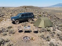
Camping While You Own
One of the biggest advantages of owning in Sangre de Cristo Ranches is that you can start using your land immediately while you plan your build. The 14-days-per-quarter camping rule means you can visit seasonally without any permits. The mountain proximity and varied terrain make Sdcr particularly appealing for camping families.
Picture this: Set up camp on your 5+ acres with the Sangre de Cristo peaks rising directly to the east. Your kids can explore different terrain types - grassland, small arroyos, and rolling hills - all on your own property. Evening campfires with mountain views and morning coffee watching sunrise light up the fourteeners.
The higher elevation means cooler summer nights - often 10-15 degrees cooler than valley floor locations. This makes summer camping more comfortable and extends the practical camping season. Many families find Sdcr perfect for July and August visits when lower elevation camping becomes uncomfortably warm.
Fall camping in Sdcr is particularly spectacular. Aspen groves in the nearby mountains turn golden, elk activity increases, and the crisp air provides excellent visibility of distant peaks. Spring brings wildflowers and wildlife movement that valley floor locations miss.
For families from the East Coast or Midwest, Sdcr represents a completely different camping experience than anything available in their home regions. True mountain views, varied terrain on your own property, and access to wilderness areas that simply do not exist in most of the country.
If you want longer stays while planning your build, the long-term camping permit process allows up to 90 days at a time with an approved septic system. This gives you a legal pathway to stay on your land for extended periods while you work through building permits and construction.
History: The Sangre De Cristo Land Grant
This corner of Colorado is not like the rest of the state. The Anglo settlement that defines most of Colorado's history arrived here much later than it did in Denver or along the Front Range. By the time the United States acquired this territory through the Treaty of Guadalupe Hidalgo in 1848, the San Luis Valley already had generations of Hispanic settlers who had built farms, dug irrigation ditches, and established communities rooted in Spanish colonial tradition.
The Sangre de Cristo Land Grant, issued in 1843 by the Mexican government, covered nearly 1.4 million acres in what is now southern Colorado. The name "Sangre de Cristo" - Blood of Christ - refers to the red-tinted light that strikes the mountain peaks at sunrise and sunset, a phenomenon particularly visible from Sdcr parcels due to their eastern orientation toward the range.
Under the grant's terms, settlers were entitled not just to their individual plots but to communal access - shared pastures, water rights, firewood-gathering grounds in the mountains. Those traditions shaped the county's character in ways that are still visible, particularly in the foothill communities closer to Sdcr.
San Luis, founded in 1851, is Colorado's oldest continuously occupied town. The San Luis People's Ditch, completed in 1852, holds the oldest continuously exercised water right in Colorado. La Vega - the common pasture on the edge of San Luis - is the only remaining communal land grant pasture in the United States, still in use by the herederos (heirs of the original grant) today.
The acequia tradition - community-managed irrigation channels maintained by shared labor and governed by elected mayordomos - is still practiced in the valley. These are not historical reenactments. They are living systems that connect modern landowners to centuries of settlement history.
In 2009, Congress designated the region as the Sangre de Cristo National Heritage Area, recognizing the cultural weight of what has survived here.
Owning land here means joining a place with deep roots. That is worth knowing, and worth respecting.
Public Lands And Recreation
Great Sand Dunes National Park and Preserve (20-30 miles) The tallest dunes in North America sit at the base of the Sangre de Cristo Mountains, rising to 750 feet above the valley floor. From Sdcr parcels, you have a direct view of the dunes and easier access than from most other valley subdivisions. The park is also designated an International Dark Sky Park, which means the star quality on a clear night ranks among the best in Colorado.
Sangre de Cristo Wilderness (10-20 miles) Direct access to one of Colorado's premier wilderness areas. The wilderness encompasses multiple fourteeners, alpine lakes, and some of the most dramatic mountain scenery in the southern Rockies. Day hiking from Sdcr to wilderness trailheads is practical.
Zapata Falls (15-25 miles) A short hike from the parking area leads to a narrow slot canyon with a waterfall tucked inside. This is one of the closer recreational attractions to Sdcr parcels and represents the kind of mountain access that valley floor properties cannot match.
Alamosa National Wildlife Refuge (35-45 miles) One of the better birding areas in the southern Rockies. Sandhill cranes stage here during their spring and fall migrations. The refuge also hosts bald eagles, great blue herons, white-faced ibis, and a variety of raptors year-round.
Rio Grande National Forest Millions of acres of wilderness access within 30-60 minutes of most Sdcr parcels. The closer proximity to National Forest land means day trips to mountain streams, hunting areas, and hiking trails that require longer drives from other valley subdivisions.
Wolf Creek Ski Area (about 1.5-2 hours west) Wolf Creek averages more than 430 inches of snow per year - among the highest snowfall totals of any ski area in Colorado. The drive from Sdcr is shorter than from most other valley locations due to better access to Highway 160.
Fourteener Access
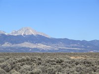
Sangre de Cristo Ranches provides some of the best fourteener access in the San Luis Valley. Four of Colorado's fourteeners - peaks above 14,000 feet - rise directly from the Sangre de Cristo range visible from Sdcr parcels:
Blanca Peak (14,345 feet) is the fourth-highest peak in Colorado and anchors the massif visible from most Sdcr properties. The standard climbing route begins from a trailhead roughly 45-60 minutes from Sdcr parcels.
Ellingwood Point (14,042 feet) and Little Bear Peak (14,037 feet) complete the Blanca massif. Little Bear is considered one of Colorado's most technical fourteeners, attracting serious climbers from around the world.
Culebra Peak (14,047 feet) sits on private land but represents the southern anchor of the range visible from Sdcr properties.
For families interested in mountain activities, having fourteeners visible from your own property creates a unique connection to Colorado's high country. Kids grow up seeing these peaks every day and understanding that they are achievable goals rather than distant impossibilities.
The climbing season typically runs from June through September, with July and August offering the most stable weather. Many Sdcr owners use their land as base camp for fourteener attempts, camping on their own property before early morning starts to the peaks.
Annual Ownership Costs
Property taxes in Costilla County are among the lowest in Colorado. Most 5-35 acre Sdcr parcels run $100-$250 annually in taxes - about $8-$21 per month. The slightly higher assessed values due to mountain proximity are offset by Costilla County's low mill levy rates. No HOA fees, no special assessments, no metro district taxes, no mandatory road maintenance fees.
Total annual ownership cost before development: approximately $100-$250 depending on the specific parcel's assessed value and acreage.
That is one of the lowest carrying costs you will find on legally accessible land in Colorado with direct mountain views and fourteener access.
Owner Financing Terms
The point of owner financing is that it removes the bank from the process entirely. No credit check, no income verification, no debt-to-income calculations. The land itself is the collateral.
Here's how it works step by step:
Contact us and confirm the parcel is available
You pay the down payment plus a $250 document fee
We send you the land contract
You can start enjoying the property recreationally while making monthly payments
At payoff, we record a warranty deed in your name with Costilla County
You own the land free and clear and can start building
No banks, no credit bureaus, no prepayment penalty. If payments stop, the contract ends and the land returns to us - but no credit reporting is ever involved. That is how owner financing differs from a mortgage.
The beauty of this system is that you can start using your land immediately - camping, hiking, exploring mountain access, planning your build - while you're still paying it off. Many families spend years enjoying weekend camping trips and seasonal visits before they ever break ground on a permanent structure.
If the standard terms do not quite fit your situation, reach out and tell us. We are real people and we would rather find terms that work than lose a buyer who is genuinely ready to start.
Honest Tradeoffs
What Sangre de Cristo Ranches parcels are not:
Not an HOA subdivision with shared amenities or groomed roads
Not a low-elevation property - higher elevation means colder winters and shorter growing seasons
Not paved road access - maintained dirt/gravel, reliable in most conditions
Not walk-on buildable - well, septic, and building permit required before permanent structure
Not near a major city - Alamosa is a small regional hub, Denver and Santa Fe are 3-4 hours
Not the cheapest valley land - mountain proximity commands a premium over valley floor parcels
Not for everyone - some people visit the San Luis Valley and cannot wait to leave. Others feel like they have come home.
The people who are happy owning here know what they signed up for. The people who are unhappy usually skipped a section like this one.
Land Maps & Attachments
Directions to Land
Take 5th Ave to US-160 E
2 min (0.3 mi)
Head toward 5th Ave
112 ft
Turn left at the 1st cross street onto 5th Ave
0.2 mi
Turn right onto Miranda Ave
384 ft
Turn left at the 1st cross street onto US-160 E
2 min (1.8 mi)
Continue on Trinchera Ranch Rd N. Drive to Pamplin Rd
7 min (4.1 mi)
Turn right onto Trinchera Ranch Rd N
1.1 mi
Turn right to stay on Trinchera Ranch Rd N
1.5 mi
Turn left onto Scheffellin Rd/Schieffelin Rd
Continue to follow Scheffellin Rd
0.6 mi
Turn right at the 1st cross street onto Hartgrave Rd
0.4 mi
Turn left onto Pamplin Rd
Destination will be on the right
More Land Details
More Land from Jean-Baptiste Ournac
 5 AC : $8K
- 5.1 AC : $9.5K
- 5 AC : $8K
- 4.9 AC : $9K
- 5.2 AC : $8.5K
- 5.1 AC : $9K
- 10 AC : $17K
- 5.1 AC : $8.5K
- New0.2 AC : $8.5K
- New0.2 AC : $8.5K
