Go Solar, Colorado Off Grid Cabin
Blanca, CO 81123
Costilla County, Colorado
Land Description
Build Solar Cabin Colorado 5 Acres Owner Finance $200 Down
Off-Grid Freedom on Your Timeline - Start Your Homestead Dream Today Without Banks or Credit Checks
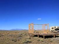
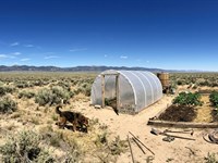
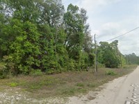
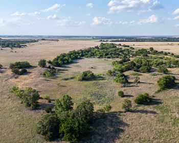
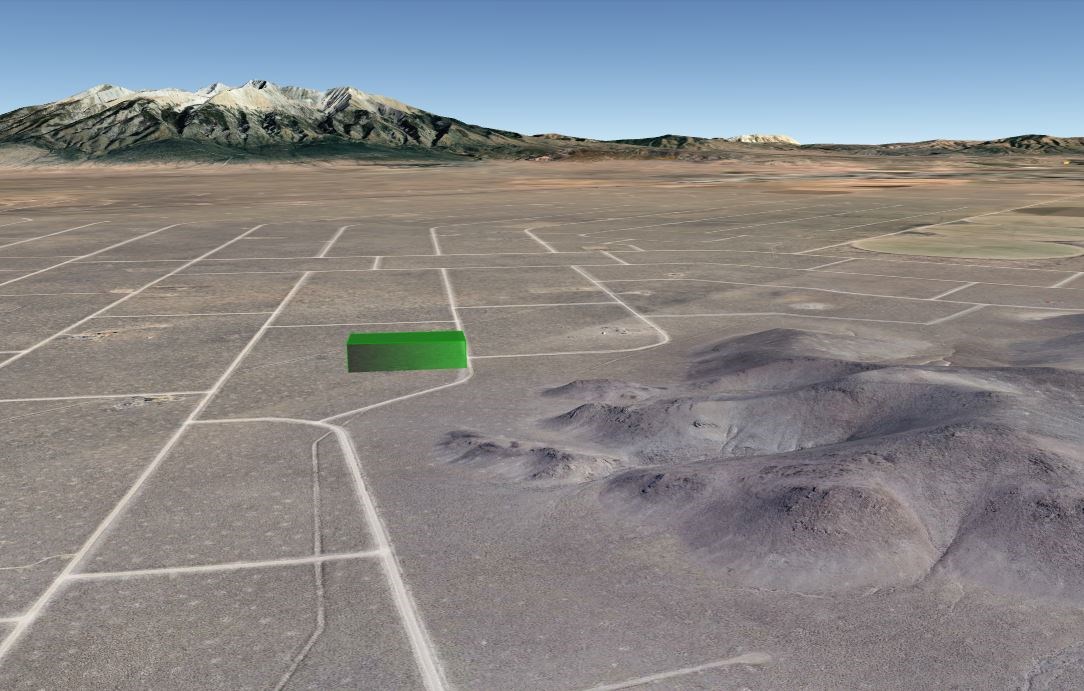
This is 5.01 acres in southern Colorado where you can build off-grid, by your own hands, on your own timeline - with no HOA, no architectural committee, and no requirement to use contractors. Colorado's abundant sunshine makes solar power an excellent choice for off-grid living. On average, the state enjoys over 300 days of sunshine per year. This parcel sits at 7,500 feet in the San Luis Valley, where thousands are discovering that off-grid living is more achievable than ever with today's technology. Solar costs have dropped dramatically, water solutions are proven, and owner financing means you can start with what you have today instead of waiting years to save the full amount. You don't have to have it all figured out before starting - action brings clarity, and taking the first step will make you proud and ready for the next one.
Property At A Glance
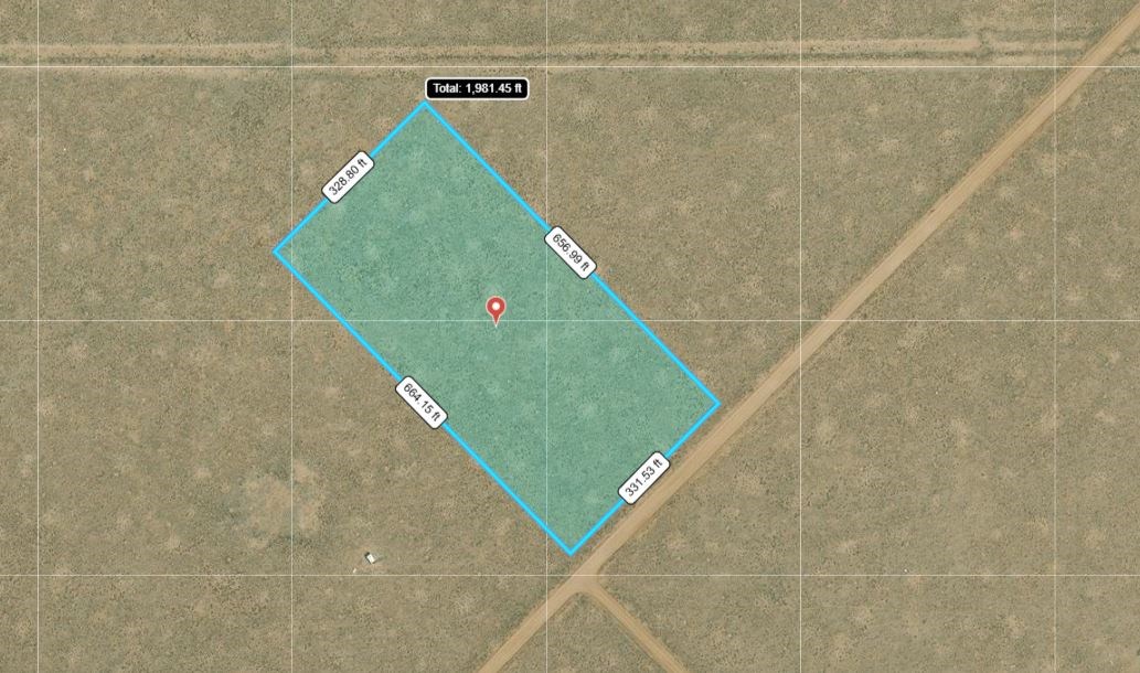
Size: 5.01 acres (218,164 square feet)
Location: Blanca, Colorado 81123
Physical Address: County Road access via Highway 159
Subdivision: San Luis Valley Ranches (Slvr), Unit 23, Block 47, Lot 4
Legal Description: Unit 23 Block 47 Lot 4, San Luis Valley Ranches
Apn: 70388410
County Account Number: 70388410
County: Costilla County, Colorado
Municipality: Unincorporated
Zoning: Estate Residential (Er)
Terrain: Level to gently rolling high-desert grassland with native vegetation
Elevation: 7,500 feet above sea level
Lot Dimensions: 462 feet x 472 feet (approximate rectangular shape)
Flood Zone: Zone C - above 500-Year floodplain, minimal flood risk
Wetlands: None identified
School District: Sierra Grande School District R-30
Annual Property Taxes: $113.40 (2025 assessment, about $9.45 per month)
HOA Dues: None - No Homeowners Association
Special Assessments: None
Metro District Fees: None
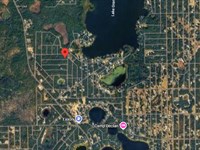
GPS Center Coordinates: 37.40176, -105.65028
Gps Corner Coordinates:
Northwest: 37.4027, -105.6514
Northeast: 37.4027, -105.6491
Southeast: 37.4008, -105.6491
Southwest: 37.4008, -105.6514
Why This Parcel Works For Off-Grid Homesteaders
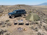
You can start immediately: $200 down and $170 per month with no bank approval, no credit check, no qualification process. Reserve this homestead land today and start camping on it this weekend while you plan your solar cabin, workshop, gardens, and water systems.
Complete building freedom: Estate Residential zoning allows manufactured homes (1976 or newer), site-built homes (600 sq ft minimum), modular homes, tiny homes meeting minimum requirements, agricultural buildings, workshops, storage structures, and multiple buildings on the same parcel. No HOA architectural review, no design restrictions, no timeline pressure to build.
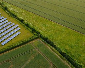
Optimal solar potential: At 7,500 feet elevation with 340+ sunny days annually, this parcel sits in one of America's premier solar zones. South-facing exposure perfect for solar panel placement. Colorado's renewable energy incentives and net metering programs support off-grid solar installations.
Water development opportunities: Well drilling allowed on this parcel. Average well depths in this Slvr section run 150-300 feet. Alternative water options include cistern systems with hauled water delivery services available throughout the San Luis Valley.
Space for complete homestead: 5.01 acres provides room for solar cabin, workshop, root cellar, gardens, greenhouse, chicken coop, storage buildings, RV parking, equipment storage, and private camping areas with natural windbreaks and privacy.
Strategic location: Highway 159 access within 1 mile. Blanca 8 minutes for fuel and basics. Fort Garland 12 minutes for hardware and groceries. Alamosa 35 minutes for Home Depot, Walmart, Tractor Supply, and major medical facilities. Remote enough for privacy, accessible enough for supplies and services.
If building your off-grid homestead dream matters to you, keep reading. If it does not, this parcel is probably not your fit.
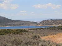
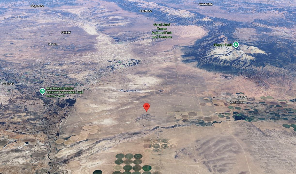
Location: The San Luis Valley - America's Largest Alpine Valley
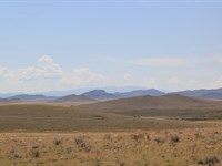
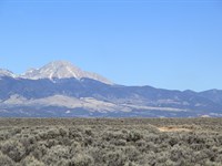
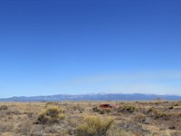
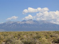
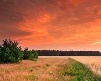
The San Luis Valley spans 8,000 square miles of high desert surrounded by 14,000-Foot peaks - the largest alpine valley in the world. This is not green Colorado. This is high desert: 7 inches annual precipitation, 340+ sunny days, daily temperature swings of 40+ degrees, and a 90-120 day growing season depending on microclimates. The valley floor sits between the Sangre de Cristo Mountains rising to 14,345 feet on the east and the San Juan Mountains reaching 14,000+ feet on the west. Mount Blanca, Colorado's fourth-highest peak, dominates the eastern skyline and is considered sacred by the Navajo. The air is thin, the sky is enormous, and the silence runs deeper than anywhere on the Front Range.
People who visit expecting Front Range Colorado - green mountains, dense forests, rushing streams - are usually disappointed. People who understand high desert beauty - endless views, dramatic light, star-filled skies, and the satisfaction of making things grow in challenging conditions - often fall in love immediately. The valley's agricultural heritage spans 175 years, with potato farms, barley fields, and cattle ranches proving that productive homesteading is absolutely possible with proper water management and season-appropriate crops.
Solar conditions are exceptional: 340+ clear days annually at 7,500+ feet elevation provides optimal solar energy production. Winter solar angles remain productive due to high elevation and reflective snow cover. Many off-grid homesteaders report their solar systems outperforming manufacturer specifications due to the valley's combination of high altitude, low humidity, and consistent sunshine.
The climate builds character: summer highs in the 80s with nighttime lows in the 40s, winter highs in the 30s with nighttime lows near zero. Spring brings wind and occasional mud season on dirt roads (typically April-May). Fall offers the best building conditions: mild days, cool nights, minimal precipitation, and low wind. This climate demands intentional home design - passive solar orientation, thermal mass, proper insulation - but rewards careful planning with extremely low heating and cooling costs.
Location: Costilla County - Colorado's Oldest Heritage
Costilla County carries the deepest historical roots in Colorado. The Sangre de Cristo Land Grant, issued by the Mexican government in 1843, originally covered 1.4 million acres stretching from the Arkansas River to the Rio Grande. After the Treaty of Guadalupe Hidalgo (1848), the United States recognized these Mexican land grants, establishing the legal framework that continues today.
Hispanic settlers from the Taos Valley founded San Luis in 1851, making it Colorado's oldest continuously inhabited town. They established the acequia system - community-managed irrigation ditches - using the San Luis People's Ditch, which holds Colorado's oldest continuously exercised water right dating to 1852. This system still irrigates valley farms today. La Vega, Colorado's only remaining common land grant, continues operating as communal pasture used by descendants of original grant holders.
The Penitente Brotherhood, a religious tradition dating to 16th-century Spain, still practices in the valley. Mission San Acacio (1860S) stands as Colorado's oldest continuously used church. The Stations of the Cross shrine in San Luis features bronze sculptures by local artist Huberto Maestas, drawing cultural tourists and pilgrims.
In 2009, Congress designated the Sangre de Cristo National Heritage Area, recognizing this region's unique role in American cultural history. This federal designation acknowledges the area's significance while supporting heritage tourism and cultural preservation.
Property taxes remain among Colorado's lowest: this 5.01-Acre parcel costs $113.40 annually (about $9.45 monthly). No special assessments, no metro district fees, no HOA dues. The county maintains friendly policies toward rural land ownership, off-grid development, and owner-builder projects. Costilla County Planning and Zoning ) provides clear guidance on permits, septic requirements, and building codes.
The county's economy balances agriculture, tourism, and growing numbers of off-grid homesteaders. Local contractors understand alternative building methods, solar installations, and water development for rural properties. Supply chains serve ranchers, farmers, and homesteaders through agricultural suppliers in Alamosa and regional distributors.
Location: San Luis Valley Ranches - Established Homestead Community
San Luis Valley Ranches (Slvr) represents one of Colorado's largest rural subdivisions, spanning different sections of Costilla County with thousands of 5-acre parcels. Established in the 1960S-1970S, Slvr was designed for recreational and residential use with 60-foot road easements, county-maintained access roads, and flexible zoning allowing various housing types.
The community attracts diverse residents: full-time off-grid homesteaders building sustainable properties, weekend recreational users camping and exploring, mid-build owners developing their land gradually, hunters using parcels as base camps, remote workers escaping urban costs, retirees seeking affordable rural living, and investors recognizing Colorado's continued population growth and land value appreciation.
SLVR's road network consists of county-maintained dirt roads suitable for standard vehicles in normal conditions. Roads receive regular grading and snow removal. During spring mud season (typically April-May) or after heavy precipitation, high-clearance vehicles provide safer access. Most residents keep older trucks or SUVs for daily valley use.
Infrastructure varies by section. This parcel sits in Unit 23, where electrical service requires extension from existing lines (contact San Luis Valley Rural Electric Cooperative: ). Most residents choose solar power due to extension costs and the valley's exceptional solar resource. Water comes from individual wells or cistern systems. Septic systems handle waste management per county requirements.
The community maintains a rural, self-reliant character. Neighbors share contractor recommendations, equipment, and expertise while respecting the privacy that draws people to rural living. Local knowledge networks help newcomers navigate well drilling, solar installation, septic permits, and county regulations. The unofficial motto: "Wave when you drive by, help when asked, mind your own business otherwise."
Property values have appreciated steadily as Colorado's population grows and remote work increases rural land demand. Slvr parcels near main roads or with special features (well, power, unique terrain) command premium prices. Standard 5-acre parcels like this one offer excellent entry points for first-time rural land buyers.
Road Access And Detailed Directions
Primary Access Route:
Highway 159 (paved state highway) to county-maintained dirt roads
Distance to Highway 159: 0.8 miles via county roads
Road surface: Maintained dirt, suitable for standard Suv/Truck
Road maintenance: Costilla County Road Department
GPS navigation: Use coordinates 37.40176, -105.65028
Distance Matrix:
Highway 159: 0.8 miles (2 minutes)
Blanca: 8 miles (12 minutes)
Fort Garland: 12 miles (18 minutes)
San Luis: 15 miles (22 minutes)
Alamosa: 35 miles (45 minutes)
Walsenburg: 75 miles (1 hour 20 minutes)
Pueblo: 110 miles (1 hour 50 minutes)
Colorado Springs: 140 miles (2 hours 40 minutes)
Denver: 210 miles (3 hours 45 minutes)
Santa Fe, NM: 150 miles (2 hours 50 minutes)
Taos, NM: 120 miles (2 hours 20 minutes)
Detailed Driving Directions from Denver:
Take I-25 South from Denver 160 miles to Walsenburg (Exit 52)
Take Us-160 West through La Veta Pass 35 miles to Fort Garland
Continue Us-160 West 15 miles through Fort Garland to Blanca
Turn South on Highway 159 toward San Luis
Follow Highway 159 South 8 miles to county road intersection
Turn East (left) on county road toward GPS coordinates
Follow county roads 0.8 miles to parcel boundary
Use GPS coordinates 37.40176, -105.65028 for exact location
Road Conditions and Vehicle Requirements:
County roads receive regular maintenance including grading, snow removal, and pothole repair. Standard SUV or pickup truck suitable for normal conditions. Sedan access possible in dry conditions but not recommended for regular use. High-clearance vehicle preferred during spring mud season (April-May) or after heavy precipitation events.
Winter access: Roads remain passable for standard vehicles during normal winter conditions. County maintains snow removal on primary access routes. Residents typically keep tire chains for emergency use during severe weather events.
Alternate Routes:
From Colorado Springs: Us-160 West direct to Blanca (avoiding I-25 to Walsenburg)
From Santa Fe: Us-285 North through Española and Antonito to Alamosa, then Us-160 East to Highway 159 junction
Comprehensive Services And Amenities
Blanca, Colorado (8 miles, 12 minutes):
Conoco Phillips gas station with convenience store
Blanca Post Office (Zip 81123) for mail service
Basic automotive services and tire repair
Small-scale groceries and camping supplies
Local cafe serving breakfast and lunch
Hardware items and ranch supplies
Population: 385 (rural agricultural community)
Fort Garland, Colorado (12 miles, 18 minutes):
Fort Garland Museum: Historic frontier fort featuring Kit Carson and Buffalo Soldiers exhibits
Mountain View Market: Full-service grocery store with fresh produce, meat, dairy
True Value Hardware: Building supplies, tools, electrical, plumbing
Fort Garland Post Office for package services
Several restaurants including Mexican cuisine and American fare
Automotive repair and services
Medical clinic for basic healthcare needs
Banking services through regional credit union
Population: 450 (historic town with tourism)
San Luis, Colorado (15 miles, 22 minutes):
R&R Market: Grocery store with local products
San Luis People's Ditch: Historic acequia system (Colorado's oldest water right, 1852)
La Vega: Colorado's only common land grant, still used communally
Stations of the Cross Shrine: Bronze sculptures by Huberto Maestas
Mission San Acacio: Colorado's oldest church building (1860S)
Several restaurants featuring local Hispanic cuisine
San Luis Museum and Cultural Center
Post office and basic services
Population: 625 (Colorado's oldest town, founded 1851)
Alamosa, Colorado (35 miles, 45 minutes) - Regional Hub:
Major Retail:
Walmart Supercenter: Full grocery, pharmacy, automotive, camping/outdoor gear
Safeway: Full-service grocery with quality produce and organic options
City Market (Kroger): Grocery and pharmacy with fuel rewards program
Home Depot: Complete building supplies, lumber, electrical, plumbing, tools
Tractor Supply Company: Rural lifestyle, farming, ranching, livestock supplies
AutoZone, O'Reilly Auto Parts: Automotive supplies and services
Healthcare:
San Luis Valley Regional Medical Center: Full-service hospital with emergency room
Multiple medical clinics and specialists
Dental and vision care services
Veterinary clinics for livestock and pets
Pharmacy services at Walmart, Safeway, and independent locations
Professional Services:
Banks: Wells Fargo, First National Bank, Valley-Wide Credit Union
Real estate offices and property management
Legal services and accounting
Engineering and surveying services
Agricultural and water well drilling contractors
Education and Culture:
Adams State University: 4-year public university with 3,200 students
San Luis Valley Airport: Regional airport with commercial flights to Denver
Multiple restaurants, hotels, and entertainment venues
Movie theater and cultural events
Valley Courier newspaper and radio stations
The Service Rhythm:
Blanca for fuel and quick needs, Fort Garland for weekly groceries and hardware, Alamosa for major supply runs and healthcare. Most Slvr residents make the Alamosa run monthly for bulk supplies and services not available in smaller towns.
Four-Season Climate And Growing Conditions
Spring (March-May):
Daytime temperatures: 50-70°F | Nighttime: 25-45°F
Precipitation: 1.5 inches (March-May total)
Characteristics: Variable weather, wind common, mud season on dirt roads typically April-May
Growing season: Begins mid-May to early June depending on elevation and protection
Advantages: Excellent time for construction, solar installation, site preparation
Challenges: Unpredictable weather, road access may require high-clearance vehicle
Summer (June-August):
Daytime temperatures: 75-85°F | Nighttime: 40-50°F
Precipitation: 2.5 inches (June-August total)
Characteristics: Dry heat, intense UV at altitude, afternoon thunderstorms possible
Growing season: Peak production period for high-altitude gardens
Advantages: Optimal building conditions, maximum solar production, comfortable camping
Solar performance: Panels operate at peak efficiency due to cool nights and clear skies
Fall (September-November):
Daytime temperatures: 45-70°F | Nighttime: 20-40°F
Precipitation: 1 inch (September-November total)
Characteristics: Stable weather, minimal wind, ideal construction season
Harvest season: Root vegetables, cold-hardy crops continue producing
Advantages: Best season for major construction projects, septic installation, well drilling
Building window: September-October optimal for concrete work, framing, roofing
Winter (December-February):
Daytime temperatures: 25-45°F | Nighttime: -5 to 15°F
Precipitation: 2 inches (December-February total, mostly snow)
Characteristics: Cold but sunny, low humidity, minimal precipitation
Construction: Interior work continues, outdoor projects limited to dry days
Solar production: Reduced hours but reflective snow maintains good panel output
Heating: Wood stoves popular, propane backup, passive solar design essential
Annual Summary:
Total precipitation: 7 inches
Sunny days: 340+ annually
Growing season: 90-120 frost-free days
Elevation effects: Intense UV requires sun protection, water evaporates quickly
Garden strategies: Season extension with greenhouses, cold frames, row covers
Building considerations: Frost line 36-42 inches, thermal mass beneficial, south-facing windows maximize winter heat gain
Homesteading Climate Advantages:
Abundant sunshine supports solar power and passive heating. Low humidity reduces pest pressure and plant diseases. Cool nights preserve energy and provide natural cooling. Predictable weather patterns allow planning of seasonal activities. Limited precipitation reduces drainage issues and foundation problems.
Climate Adaptation Strategies:
Water conservation through mulching, drip irrigation, rainwater catchment. Wind protection with trees, berms, or structures. Soil improvement with organic matter to retain moisture. Season extension techniques for food production. Building design incorporating passive solar, thermal mass, and proper orientation.
Comprehensive Building And Zoning Regulations
Estate Residential Zoning Specifications:
Costilla County Estate Residential (Er) zoning allows maximum flexibility for rural residential development while maintaining safety standards and property values.
Permitted Primary Structures:
Site-built homes: Minimum 600 square feet finished living space
Manufactured homes: 1976 or newer, Hud-Certified, permanent foundation required
Modular homes: Factory-built, state-certified, meets current building codes
Mobile homes: 1976 or newer, proper setup and skirting required
Log homes: Site-built or kit construction, meets International Residential Code
Adobe construction: Owner-built allowed with proper permits and inspections
Straw bale construction: Permitted with engineering approval for structural elements
Earth-sheltered homes: Bermed or underground, requires engineering and drainage plan
Permitted Accessory Structures:
Detached garages and carports (any size)
Workshops and storage buildings (no size limit on agricultural properties)
Agricultural buildings: Barns, equipment storage, livestock shelters
Greenhouses and garden structures
Guest houses or caretaker quarters (with separate septic approval)
RV storage buildings and covered parking
Solar panel ground mounts and battery storage buildings
Well houses and utility buildings
Root cellars and food storage structures
Multiple Building Rights:
Estate Residential zoning permits multiple structures on single parcels. No limit on number of accessory buildings. Primary residence plus guest house allowed with proper septic capacity. Agricultural buildings unlimited for food production and livestock.
Setback Requirements:
Front setback: 25 feet from property line
Side setbacks: 10 feet from property lines
Rear setback: 15 feet from property line
Well separation: 100 feet from septic system, 50 feet from property lines
Septic setbacks: 100 feet from wells, 10 feet from structures
Building Timeline and Permits:
No deadline to obtain building permits - take time to plan properly. Building permits valid for one year from issuance, renewable annually. Three years maximum from permit issuance to completion of construction. Extensions available for valid reasons (weather, financing, family circumstances).
Owner-Builder Rights:
Colorado allows property owners to build their own primary residences without general contractor licenses. Owner must obtain all permits, schedule inspections, ensure code compliance. Electrical and plumbing work may require licensed professionals depending on scope. Foundation, framing, roofing, and finish work can be owner-performed with proper permits.
Permit Process Sequence:
Minor Development Permit: Driveway access, temporary power, site preparation ($200-300)
Septic Permit: Soil evaluation, system design, installation permit ($300-500)
Well Permit: Colorado Division of Water Resources application ($75-150)
Building Permit: Plans submission, plan review, permit issuance ($500-2000 depending on size)
Construction Phase: Foundation, framing, electrical, plumbing, final inspections
Occupancy Permit: Final approval for habitation
RV and Temporary Housing Regulations:
Recreational camping: 14 days maximum per 3-month period without permits
During construction: Extended RV living allowed with approved septic and long-term camping permit
Permanent RV living: Requires permanent foundation, septic connection, utility hookups
Temporary structures: Construction trailers and tool storage allowed during active building
Building Code Standards:
International Residential Code (Irc) adopted by Costilla County. Energy efficiency standards encourage but do not mandate renewable energy systems. Seismic and wind load requirements minimal due to stable geology and protected location. Foundation requirements: 42-inch frost depth, reinforced concrete footings.
Inspection Requirements:
Foundation inspection before concrete pour. Framing inspection before insulation. Electrical rough-in before drywall. Plumbing rough-in before insulation. Final inspection before occupancy permit. Most inspections scheduled within 48 hours of request.
Contact Information:
Costilla County Planning and Zoning:
Building permits and code questions
Address: 354 Main Street, San Luis, CO 81152
Office hours: Monday-Friday 8:00 AM - 4:30 Pm
Complete Off-Grid Utilities And Systems Guide
Water Development Options:
Option 1: Domestic Water Well
Average depth range: 150-300 feet in this Slvr section
Drilling cost: $15-25 per foot (total $2,250-7,500 for average depth)
Well pump and pressure system: $3,000-5,000 installed
Pressure tank, electrical, plumbing connections: $1,500-2,500
Total well system investment: $7,000-15,000 complete
Permit required: Colorado Division of Water Resources )
Local drilling contractors: Valley Pump Company, San Luis Valley Well Drilling
Water quality: Generally excellent, minimal treatment required
Capacity: Typically 5-20 gallons per minute in this area
Option 2: Cistern and Water Hauling
Cistern installation: $2,000-4,000 for 1,500-Gallon buried system
Water delivery services available:
San Luis Water Department: 500 gallons for $25
Sangre de Cristo Water Services: 1,000 gallons for $100 plus $6.50/Mile
Moreland Mercantile Llc: $0.15/Gallon delivered
12V pump system for cistern: $800-1,200 installed
Backup storage: Multiple tank systems for redundancy
Winter protection: Buried lines, heat tape, insulated pump house
Option 3: Rainwater Harvesting
Colorado allows rainwater collection for domestic use (up to 110 gallons storage)
Collection area: 2,000 sq ft roof captures ~850 gallons per inch of rainfall
Annual collection potential: ~6,000 gallons with average precipitation
Filtration system required: $1,000-3,000 for potable water system
Supplementary system: Combines with well or delivery for complete supply
Septic System Requirements:
Standard Septic Installation:
Soil evaluation required: $300-500 by licensed contractor
System design and permitting: $500-800
Standard system components: 1,250-Gallon concrete or plastic tank, distribution box, leach field
Installation cost: $8,000-15,000 for standard system on suitable soil
Alternative systems: Mound systems for challenging soils ($15,000-25,000)
Owner installation: Permitted with proper permits and county inspections
Local Septic Contractors:
SLV Septic Services: Local contractor with excellent reputation
Land Systems West: Septic and solar system integration
Valley Excavation: Site preparation and septic installation
Power System Development:
Solar Power Systems (Recommended):
Basic System (1-2 kW): $8,000-12,000 installed
Powers LED lighting, small appliances, phone/laptop charging
6-8 solar panels, battery bank, charge controller, inverter
Suitable for basic cabin or RV-style living
Standard System (3-5 kW): $15,000-25,000 installed
Powers full household except heavy heating/cooling
12-20 solar panels, larger battery bank, hybrid inverter system
Handles refrigeration, power tools, washing machine, electronics
Comprehensive System (6-10 kW): $30,000-50,000 installed
Powers all household needs including electric heat backup
24-40 solar panels, substantial battery storage, backup generator integration
Commercial-grade components, professional monitoring systems
Grid Connection Alternative:
San Luis Valley Rural Electric Cooperative:
Extension cost: $5-8 per foot from nearest power line
Nearest lines: Approximately 2+ miles (estimated $50,000+ extension)
Monthly service: $40-60 base plus usage charges
Most Slvr residents choose solar due to extension costs
Backup Power Options:
Propane generators: 8-20 kW systems ($3,000-8,000)
Gasoline/Diesel backup: Portable units for emergency power
Wind power potential: Limited due to inconsistent wind patterns
Micro-hydro: Not applicable (no flowing water on parcel)
Communication and Internet:
Starlink Satellite Internet:
Service area: Available throughout Slvr with clear sky view
Speeds: 50-200+ Mbps download, 10-20 Mbps upload
Monthly cost: $110-120 for residential service
Equipment cost: $599 one-time for dish and router
Installation: User-friendly, typically self-installed
Reliability: Excellent for rural areas, occasional weather interruptions
Cellular Service:
Verizon: Strongest coverage in Slvr area
AT&T: Good coverage with occasional dead zones
T-Mobile: Variable coverage, weaker in valley
Signal boosters: $300-800 for home cellular enhancement
Internet backup: Cellular hotspot plans available for Starlink backup
Traditional Options:
HughesNet/Viasat: Satellite internet with data caps
Dial-up: Still available but extremely slow
Fixed wireless: Limited availability from regional providers
Heating and Propane Services:
Wood Heat (Primary Heating Method):
Abundant firewood sources in San Juan and Sangre de Cristo National Forests
Firewood cutting permits: US Forest Service (seasonal permits available)
Local firewood suppliers: $150-200 per cord delivered
Wood stove installation: $2,000-5,000 including chimney and safety clearances
Heating cost: $500-1,000 annually with efficient wood stove
Propane Services and Suppliers:
San Luis Valley Propane: Delivery service throughout Slvr
A-1 High Valley Propane: , serves Costilla County
La Veta Propane: Regional distributor with delivery service
Tank rental: $50-100 annually for 500-1000 gallon tanks
Propane costs: $2.50-3.50 per gallon delivered
Uses: Cooking, hot water, backup heating, generator fuel, refrigeration
Waste Management:
GT Trash Services: Weekly pickup available on main roads
Silver Mountain Disposal: Regional waste management
Self-haul option: Transfer station in Alamosa
Recycling: Limited facilities in Alamosa for basic materials
Composting: Ideal solution for organic waste in rural setting
Public Lands And Outdoor Recreation Paradise
The San Luis Valley sits at the center of millions of acres of public lands, creating an outdoor recreation paradise for hiking, hunting, fishing, stargazing, and wilderness exploration. This parcel provides private base camp access to some of Colorado's most spectacular and least crowded natural attractions.
Great Sand Dunes National Park and Preserve (45 miles):
North America's tallest sand dunes rise 750 feet above the valley floor, creating a 30-square-mile sandbox for sandboarding, sand sledding, and hiking. The park's 150,000 acres include the dunefield, Medano Creek (seasonal beach experience), and 13,000-Foot peaks in the Sangre de Cristo Wilderness.
International Dark Sky Park designation makes Great Sand Dunes one of America's premier stargazing destinations. The park offers astronomy programs, night sky photography workshops, and unobstructed views of the Milky Way. Bortle Class 1 skies provide visibility of deep space objects impossible to see near urban areas.
Visitor amenities: Developed campground, visitor center, ranger programs, backcountry camping permits. Day use activities: Dune climbing, sandboarding equipment rentals, nature walks, creek play during spring snowmelt (May-July).
Alamosa National Wildlife Refuge (40 miles):
11,169 acres of wetlands, grasslands, and riparian habitat along the Rio Grande. Peak sandhill crane migration occurs March 15-April 15 and October 1-November 15, with populations reaching 20,000+ birds. The refuge also supports 200+ other bird species, making it a premier birding destination.
Wildlife viewing opportunities: Sandhill cranes, great blue herons, white-faced ibis, northern pintails, mallards, Canada geese, bald eagles, golden eagles, elk, mule deer, black bears. Photography blinds and observation platforms provide excellent viewing opportunities.
Visitor facilities: Visitor center, driving tour route, walking trails, hunting programs (waterfowl and upland birds), fishing access, environmental education programs.
Monte Vista National Wildlife Refuge (50 miles):
15,000 acres of managed wetlands and grasslands. Home to the annual Monte Vista Crane Festival (mid-March), celebrating sandhill crane migration with guided tours, photography workshops, educational programs, and community events. The festival attracts 15,000+ visitors annually and provides excellent networking opportunities with other outdoor enthusiasts.
Activities: Wildlife viewing, photography, waterfowl hunting, fishing, nature walks, educational programs. The refuge maintains several shallow lakes and seasonal wetlands that provide crucial habitat for migratory birds along the Central Flyway.
Rio Grande National Forest (15 miles to boundary):
1.8 million acres of wilderness, peaks, forests, and rivers stretching from the San Luis Valley to the Continental Divide. Access points within one hour of this parcel provide entry to hundreds of thousands of acres of backcountry.
Wilderness Areas accessible: Sangre de Cristo Wilderness (226,455 acres), South San Juan Wilderness (158,790 acres), Weminuche Wilderness (499,771 acres). These designated wilderness areas prohibit motorized travel, maintaining primitive conditions for hiking, backpacking, horseback riding, and solitude.
Activities: Hiking, backpacking, fishing, hunting, cross-country skiing, snowshoeing, mountain climbing, wildlife viewing. Fourteen peaks over 14,000 feet lie within reasonable access from the San Luis Valley.
Wolf Creek Ski Area (2 hours):
Colorado's highest ski area (10,300-11,904 feet) averages 430+ inches of annual snowfall. Less crowded than Front Range resorts, offering excellent powder skiing and family-friendly atmosphere. Day tickets, season passes, and ski lessons available. Summer activities include scenic chairlift rides and mountain biking.
Hidden Gems and Lesser-Known Destinations:
Penitente Canyon (1 hour):
Bureau of Land Management recreation area featuring some of Colorado's best rock climbing and mountain biking. Volcanic tuff formations create unique climbing routes from beginner to expert levels. Mountain biking trails wind through high desert terrain with spectacular views of the Sangre de Cristo Mountains.
Facilities: Primitive camping, picnic tables, vault toilets. No fees required for day use. Popular with locals but rarely crowded. Excellent destination for weekend camping trips from your Slvr base camp.
Joyful Journey Hot Springs (1.5 hours):
Natural hot springs resort featuring multiple pools with temperatures ranging from 98-108°F. Mountain views, yurt accommodations, camping facilities, and massage services. Day use and overnight stays available. Popular winter destination for soaking after skiing or snowshoeing.
Valley View Hot Springs (2 hours):
Clothing-optional natural hot springs operated by Orient Land Trust. Multiple pools at different temperatures, primitive camping, dark sky protection. Reservations required. Unique destination for those seeking natural hot springs experience without commercial development.
Los Caminos Antiguos Scenic Byway:
129-mile scenic loop following Highways 142, 160, and 159 through Colorado's oldest settlements. The route passes through San Luis, Manassa, Antonito, and Fort Garland, showcasing Hispanic heritage sites, historic churches, and traditional architecture. Self-guided tour brochures available highlighting cultural and historical stops.
Zapata Falls (45 miles):
Short hike to spectacular slot canyon waterfall. The trail requires wading through ankle-deep water in the narrow canyon to reach the 30-foot falls. Excellent day hike combining scenic drive, moderate hiking, and unique geological features.
Crystal Lakes (1.5 hours):
High-country fishing destination requiring 4-wheel drive access. Remote lakes offering brook trout, rainbow trout, and solitude. Primitive camping, spectacular scenery, and minimal crowds. Excellent destination for those seeking backcountry fishing experience.
Land Maps & Attachments
Directions to Land
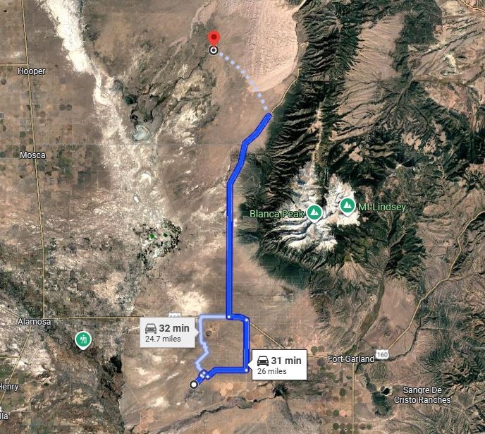
From Blanca, Colorado, head west on Main Street / US-160 W.
Continue west on US-160 W for about 8 miles, then turn left and head south toward Somerset Road.
Continue south on the local dirt road network until you reach the area of Somerset Road near the property coordinates: 37.4011389, -105.6510833.
The property is located off Somerset Road in the Blanca area. Roads in this area are rural dirt roads, so it is best to use the GPS coordinates as you get close and check road conditions before driving out.
Approximate drive time: 15 to 20 minutes from Blanca.
Approximate distance: about 10 to 11 miles.
More Land Details
More Land from Jean-Baptiste Ournac
 5 AC : $8K
- 5.1 AC : $9.5K
- 4.9 AC : $9K
- 5.2 AC : $8.5K
- 5.1 AC : $18K
- 5.1 AC : $9K
- 10 AC : $17K
- 5.1 AC : $8.5K
- New0.2 AC : $8.5K
- New0.2 AC : $8.5K