Lot N, The Woods at Flint Ridge
Newark, OH 43056
Licking County, Ohio
Land Description
Lot N - The Woods at Flint Ridge
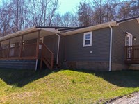
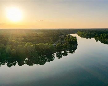
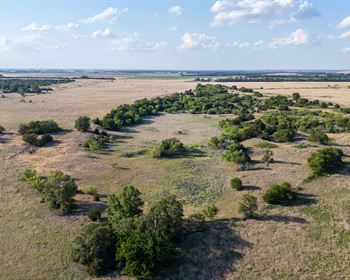
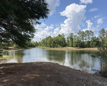
3.5 Acre Wooded Estate Home Site
Mulberry Rd, Hopewell Twp, Licking Co, Ohio
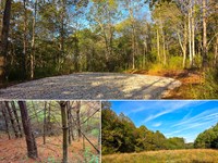
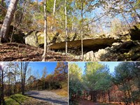
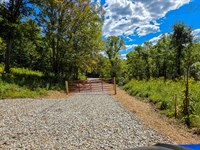
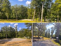
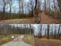
Picturesque Wooded Estate Home Site
Walking Distance to Flint Ridge State Memorial
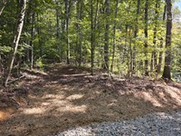
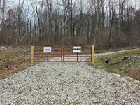
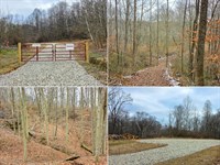
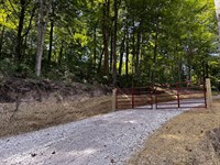
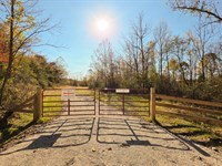
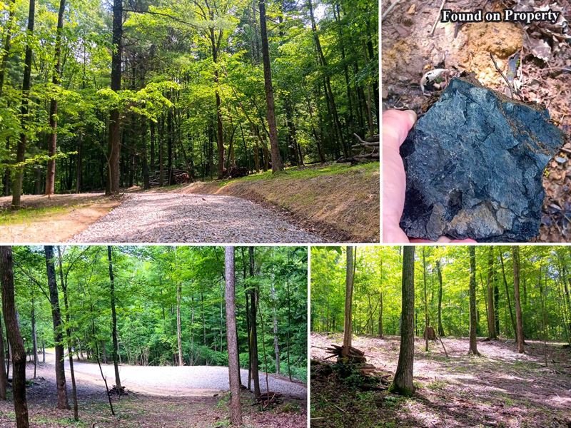
New Gravel Driveway Installed to Private Wooded Building Site
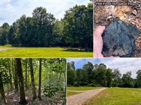
Beautiful Mature Woods with Extensive Trails Throughout
Choose Your Own Builder - No Time Limit To Build
Gently Sloping Terrain, Well Suited for Walk-Out Basement
Soil Testing Complete for Onsite Septic
Scenic Park-like Setting
3.501 Acres - Lot N at The Woods at Flint Ridge
Additional Tracts Available
No Zoning and No Deed Restrictions
Oil and Gas Rights Transfer
Natural Gas Located on Flint Ridge Rd
Power Available: Licking Rural Electrification
West Muskingum Local School District
Hopewell Twp, Licking County
Parcel-00.011
Current Annual Taxes are $529.42
The Woods at Flint Ridge is Located:
~.5 Miles to Flint Ridge State Memorial
11 Miles to Newark
12 Miles to Heath
15 Miles to Buckeye Lake
15 Miles to Zanesville
16 Miles to Somerset
32 Miles to Johnstown
34 Miles to Intel Plant
37 Miles to Columbus
0 Mulberry Rd, Newark, OH 43056
Gps Coordinates: 39.989819, -82.244144
Google Map Link
WoodsFlintRidge Map
Maps and Additional Documentation
Flint Ridge, Lot J - Soil Evaluation.pdf
Flint Ridge, Lot L - Soil Evaluation.pdf
Flint Ridge, Lot M - Soil Evaluation.pdf
Flint Ridge, Lot N - Soil Evaluation.pdf
The Woods at Flint Ridge - Aerial Map.pdf
The Woods at Flint Ridge - Parks Location Map.pdf
The Woods at Flint Ridge - Survey.pdf
Distance to Flint Ridge Memorial & Topography Map.pdf
Flint Ridge Kml.Kml
Other Properties in WoodsFlintRidge
Tract JSoldTract LAvailableTract MSoldTract NAvailable
Property Location
? Map Options
Street Map
Satellite View
Hybrid View
Topographic Map
Countrytyme Properties Within 10 Miles
Property Images
Countrytyme Land Specialists3451 Cincinnati-Zanesville Road SW - Lancaster, OH 43130Call Us 1-Call Us Toll website uses cookies in compliance with Google Indexing, if you wish to opt out from tracking please call us and we will provide the information to you directly.
const galleryItems document.querySelectorAll('.gallery-item');
const lightbox document.getElementById('lightbox');
const lightboxImg document.getElementById('lightbox-img');
let currentIndex 0;
Galleryitems.Foreach(Item {
item.addEventListener('click', () {
currentIndex parseInt(item.getAttribute('data-index'));
lightboxImg.src item.getAttribute('data-full');
lightbox.classList.add('active');
function closeLightbox() {
lightbox.classList.remove('active');
function changeImage(direction) {
currentIndex + direction;
if (currentIndex galleryItems.length) currentIndex 0;
Lightboximg.Src galleryItems[currentIndex].getAttribute('data-full');
lightbox.addEventListener('click', (e) {
if (e.target lightbox) closeLightbox();
document.addEventListener('keydown', (e) {
if {
if (e.key 'Escape') closeLightbox();
if (e.key 'ArrowLeft') changeImage(-1);
if (e.key 'ArrowRight') changeImage(1);
// Initialize map with property coordinates
const propertyLat 39.989819;
Const propertyLng -82.244144;
// Map tile layers
const mapLayers {
street: L.tileLayer(' {
attribution: '© OpenStreetMap contributors',
maxZoom: 19
Satellite: L.tileLayer(' {
attribution: '© Esri',
maxZoom: 19
Hybrid: L.tileLayer(' {
attribution: '© Google',
maxZoom: 20
Topo: L.tileLayer(' {
attribution: '© Esri',
maxZoom: 19
// Define zoom levels for each map type
const mapZoomLevels {
street: 11, // Default street view
satellite: 17, // ~500 meters
hybrid: 17, // ~500 meters
topo: 17 // ~500 meters
// Initialize map with error handling
try {
const map L.map('propertyMap', {
center: [propertyLat, propertyLng],
zoom: mapZoomLevels.street,
layers: [mapLayers.street],
zoomControl: true,
attributionControl: true
// Add marker for property location
const marker L.marker([propertyLat, propertyLng])
.addTo(map)
.bindPopup("Current PropertyLot N - The Woods at Flint Ridge", {
closeButton: true,
offset: L.point(0, -25),
Autopan: true,
autoPanPadding: [50, 50],
Classname: 'property-popup'
// Store nearby listing markers
let nearbyMarkers [];
// Function to change map type with error handling
function changeMapType(type) {
try {
// Remove all base layers
Object.values(mapLayers).forEach(layer {
if (map.hasLayer(layer)) {
map.removeLayer(layer);
// Clear any nearby property markers when changing map type
nearbyMarkers.forEach(marker map.removeLayer(marker));
nearbyMarkers [];
// Add selected base layer
map.addLayer(mapLayers[type]);
// Reset view to focus on main property
map.setView([propertyLat, propertyLng], mapZoomLevels[type] || mapZoomLevels.street);
// Update active button
document.querySelectorAll('.map-controls button').forEach(btn {
btn.classList.remove('active');
event.target.classList.add('active');
} catch (error) {
console.error('Error changing map type:', error);
// Function to show/hide nearby listings
function showNearbyListings(event) {
const button document.getElementById('nearbyButton');
// Clear any existing markers first
nearbyMarkers.forEach(marker map.removeLayer(marker));
nearbyMarkers [];
// Show nearby listings
button.textContent "Loading Properties...";
console.log("Fetching nearby listings...");
// Fetch nearby listings from the server
fetch('./get_nearby_listings.php?lat ' + propertyLat + '&lng ' + propertyLng + '&id ' + 1788 + '&radius 10')
.Then(Response {
console.log("Server response received:", response.status);
return response.json();
.then(data {
console.log("Found nearby listings:", data.length, data);
if (data.length 0) {
alert('No other properties found within 10 miles');
button.textContent "Find Properties Within 10 Miles";
return;
// Create markers for each nearby listing
data.forEach(listing {
const marker L.marker([listing.lat, listing.lng]).addTo(map);
// Configure popup options for better positioning
const popupOptions {
closeButton: true,
offset: L.point(0, -25), // Position popup closer to marker
autoPan: true, // Ensures popup is visible in viewport
autoPanPadding: [50, 50], // Padding when auto-panning
className: 'property-popup' // Custom class for styling
marker.bindPopup('
${listing.name}
${listing.price ? '$' + Number(listing.price).toLocaleString() : 'Price not available'}
${listing.acreage ? listing.acreage + ' acres' : ''}
${Listing.Status || ''}
View Property
', popupOptions);
nearbyMarkers.push(marker);
// Adjust map bounds to show all markers
const allMarkers [marker...nearbyMarkers];
const group L.featureGroup(allMarkers);
map.fitBounds(group.getBounds().pad(0.1));
button.textContent "Find Properties Within 10 Miles";
// Don't remove active class from this button
if (event) event.stopPropagation();
.catch(error {
console.error('Error fetching nearby listings:', error);
button.textContent "Find Properties Within 10 Miles";
alert('Unable to fetch nearby properties. Please try again later.');
} catch (error) {
console.error('Error initializing map:', error);
function toggleMapControls() {
const mapControls document.querySelector('.map-controls');
const hamburgerIcon document.querySelector('.hamburger-icon');
mapControls.classList.toggle('show');
if {
hamburgerIcon.textContent '?';
} else {
hamburgerIcon.textContent '?';
Function openFirstImage() {
if (galleryItems.length 0) {
currentIndex 0;
Lightboximg.Src galleryItems[0].getAttribute('data-full');
lightbox.classList.add('active');
function myFunction() {
var y '39.989819,-82.244144';
Window.Open(" + y , "_blank");
Gps: 39.989819, -82.244144
Land Maps & Attachments
More Land Details
Land Price History
More Land from Countrytyme Realty
 6.3 AC : $67.9K
- 6 AC : $74.9K
- 21.5 AC : $270K
- 2.1 AC : $39.9K
- 11.4 AC : $103K
- 21.4 AC : $260K
- 8.3 AC : $82.9K
- 5.5 AC : $64.9K
- 5 AC : $58.9K
- 28.1 AC : $350K
- 7.6 AC : $79.9K
- 5.5 AC : $110K